Top Things to Do in Guadalupe Mountains National Park
For some, the idea of west Texas conjures up images of flat, open plains, and vast, never-ending horizons. But this is a region that is remarkably varied in its topography, as evidenced by the towering mountain range that resides in Texas’s lesser known National Park, Guadalupe Mountains National Park. Need more proof? The highest point in Texas, Guadalupe Peak, can be summited here, at over 8,000 feet tall! While many people may not even be aware that there is a second National Park in the Lone Star State, what makes this place so special is that it contains a stark, rugged wilderness, full of challenging trails, secluded backcountry, and a feeling that lends itself to being miles away from any signs of civilization. If you are looking for a National Park to truly escape to, then read up on the top things to do in Guadalupe Mountains National Park, including hiking in Guadalupe Mountains National Park and Guadalupe Mountains National Park camping!

Disclosure: Below are some affiliate links-these are all products I highly recommend. I won’t make any recommendations on this page that I haven’t tested or personally used! Enjoy this guide to the top things to do in Guadalupe Mountains National Park!
Table of Contents
Top Things to Do in Guadalupe Mountains National Park
Both of Texas’s National Parks, both Big Bend and Guadalupe Mountains, lie in obscure, isolated areas of West Texas. While some people may see this as a downside to these parks, I see it as one of their most unique qualities. Here in the twin parks of West Texas, you can find a stunning tapestry of mountains, deserts, canyons, and forest, draped in seclusion and solitude, and Guadalupe Mountains National Park sums up all these characteristics perfectly. It is this multi-faceted environment that creates so many incredible things to do in Guadalupe Mountains National Park.
CHECK OUT: The Perfect Texas National Parks Itinerary
This guide to Guadalupe Mountains National Park includes:
- Location of Guadalupe Mountains National Park
- What to Know Before You Go
- Hiking in Guadalupe Mountains National Park
- Camping in Guadalupe Mountains National Park
- Other Top Things to Do in Guadalupe Mountains National Park
Location of Guadalupe Mountains National Park
Location of Guadalupe Mountains National Park in West Texas
Guadalupe Mountains National Park resides in the corners of west Texas, just under 2 hours east of El Paso, and 1 hour south of Carlsbad, New Mexico, and its famous Carlsbad Caverns. The closest major airport is in El Paso International.
The closest towns are Dell City, Texas, to the west, and Carlsbad, New Mexico, to the northeast. You can also check out Whites City, New Mexico, a small motel and RV establishment directly at the entrance to Carlsbad Caverns National Park, and only about 30 minutes from Guadalupe Mountains National Park. It is a great home base if you are planning to visit BOTH of these National Parks during the same trip!
Insider Tip: Carlsbad Caverns is actually a part of the same mountain range that houses Guadalupe Mountains National Park
Helpful Driving Distances:
- Carlsbad, NM to Guadalupe Mountains National Park: 1 hour
- Carlsbad Caverns National Park to Guadalupe Mountains National Park: 30 minutes
- Whites City, NM to Guadalupe Mountains National Park: 30 minutes
- Dell City, TX to Guadalupe Mountains National Park: 40 minutes
- El Paso International Airport to Guadalupe Mountains National Park: 1 hour and 45 minutes
What to Know Before You Go
ENTRANCE FEES: It costs $10 per person to enter Guadalupe Mountains National Park. Visitors can pay cash or credit at the Pine Springs Visitors Center upon entering, or at any of the self pay stations available at all the trailheads.
PARK HOURS: open 24 hours a day year round
PARK ALERTS: you can check for park alerts HERE
PET POLICY: pets are NOT allowed on trails (with the exception of the Pinery Nature Trail) or in park buildings. See full pet policy HERE.
BEST TIME OF YEAR TO VISIT: The best time to visit Guadalupe Mountains National Park is spring and fall. The summer heat can be brutal, and it is not recommended to hike during the day for extended amounts of time. Winter can be quite enjoyable to hike, though the Guadalupe Mountains can get cold and windy, so you will want to layer appropriately before visiting. The Guadalupe Mountains do get a handful of bad winter storms that roll through each year, so you will just want to check the weather and park alerts before a winter visit. Also, keep in mind that Guadalupe Mountain National Park ranges greatly in elevation, so weather at the base might be different than weather at the top of a 8,000 foot tall peak! And as always, if the rangers advise against a certain activity (I have had them advise against certain things, such as camping at the backcountry site on Guadalupe Peak due to extreme high wind warnings), take heed of their warnings.
CAMPGROUNDS: there are 2 developed campgrounds in Guadalupe Mountains National Park: the Pine Springs Campground and the Dog Canyon Campground. Spots are reservable online HERE. Backcountry camping requires a wilderness permit.
LODGING: there are hotels and vacation rentals available in nearby Dell City, TX, and Carlsbad, NM. Carlsbad is a larger town and therefore will have more lodging options. There is also Whites City, NM, a small local establishment, that is close to both Guadalupe Mountains National Park and Carlsbad Caverns National Park.
Check Availability for Your Trip!
Tips For Visiting Guadalupe Mountains National Park
- Be sure to fill up with gas and food, etc., before arriving at the park. There are no resources near the park (closest place is Carlsbad, New Mexico, Whites City, NM, or Dell City, Texas).
- Guadalupe Mountains National Park sits right on the timezone change. Be sure to be aware of the current correct time, depending on where you are coming from.
- If you are planning to hike at higher altitudes, like the Guadalupe Peak Trail, be sure to check weather-forecast.com for mountain forecasts specifically, as weather near a summit can be drastically different than weather at the base.
- Be sure to bring plenty of water, even in the non-summer months.
- Bring optional cash for entrances fees to be paid at the trailhead (or pay at Visitors Center with card)
- Explore with the right gear – Guadalupe Mountains National Park is a very remote and rugged wilderness!
- Familiarize yourself with hiking trails beforehand
- Stay on designated trails at all times
- Respect wildlife -never approach or feed animals
- Bring hiking snacks or picnic foods – food options are limited inside the park and in the immediate vicinity
- Leave No Trace – pack it in, pack it out!
- This is very rugged, and often secluded wilderness. When I have hiked here, there are always stretches of several hours where I may not see another person. In conditions like these, always ensure that you have a safe hiking habits in place, especially if you are planning to hike solo.
Hiking in Guadalupe Mountains National Park
One of the best ways to get acquainted with this park is by taking on some of its best hiking trails. The opportunities for hiking in Guadalupe Mountains National Park range from easy to incredibly challenging, while simultaneously encompassing a wide array of terrain and scenery.
The 8 best hikes in Guadalupe Mountains National Park include:
- Guadalupe Peak
- McKittrick Canyon Trail
- Devils Hall Trail
- El Capitan
- Smith Spring and Manzanita Spring Loop Trail
- Pinery Nature Trail
- The Bowl and Hunter Peak
- Salt Basin Dunes Trail

Map of the Best Hiking in Guadalupe Mountains National Park
Locations of the best hiking in Guadalupe Mountains National Park
#1: The Guadalupe Peak Trail
Guadalupe Peak Trail route
LENGTH: 8.1 miles roundtrip out and back
RATING: Difficult
BEST TIME OF YEAR TO HIKE: Spring and Fall
ESTIMATED TIME TO COMPLETE: 4 – 7 hours
ELEVATION: 8,750 feet
ELEVATION GAIN: 2,949 feet

Insider Tip: there is a backcountry campsite located about a mile below the summit of Guadalupe Peak, for those hikers interested in extending the experience overnight. A permit is required for all backcountry wilderness camping.
Climbing Texas’s tallest peak will immediately disprove the misconception that west Texas is all flat. This hike also will give you a glimpse into the fascinating topography and ecosystems of the area. On this hike visitors will discover open desert expanses at the onset, shady, pine forests at higher elevation, and a rocky summit that overlooks the panoramic views of the El Paso salt basin, the peaks of neighboring mountains such as El Capitan, and the whole of Guadalupe Mountains National Park. All this in a little over 8 round trip miles. This is a great peak to bag for anyone interested in “high-pointing” the tallest point in Texas. In fact, out of the 45 state high points I have snagged to date, Guadalupe Peak was my very first one. It remains one of my all time favorites, even when stacked up against other impressive high points like California’s Mt. Whitney or Oregon’s Mt. Hood. It is the only one I have hiked multiple times as well.
CHECK OUT: The 50 State High Points in the U.S.


#2: The McKittrick Canyon Trail
LENGTH: 21.3 miles roundtrip out and back
RATING: Moderate – Difficult
BEST TIME OF YEAR TO HIKE: Spring and Fall
ESTIMATED TIME TO COMPLETE: 10 – 12 hours
ELEVATION GAIN: 4,232 feet

McKittrick Canyon Trail Elevation Chart
Some of the best hiking in Guadalupe Mountains National Park can be found along the surprisingly lush McKittrick Canyon Trail, which ascends from the desert floor up the height of the canyon, and includes features such as the historic Pratt and Hunter Line Cabins, the intriguing Grotto, and the breathtaking view from The Notch. This hike also encompasses several unique features of Guadalupe’s multiple environments, including desert, riparian, and rocky canyons. For a real treat, visit in the fall season when the colors of McKittrick easily rival the Northeast!
Because this is a lengthy trail, most visitors opt to complete it as an overnight backpacking trek, and take advantage of the backcountry campsite on the trail. But there are several ideal “turnaround” spots for those wishing for a shorter day hike on the McKittrick Canyon Trail: Pratt Cabin, Hunter Line Cabin, or the Grotto are all excellent landmarks for a shorter hike.


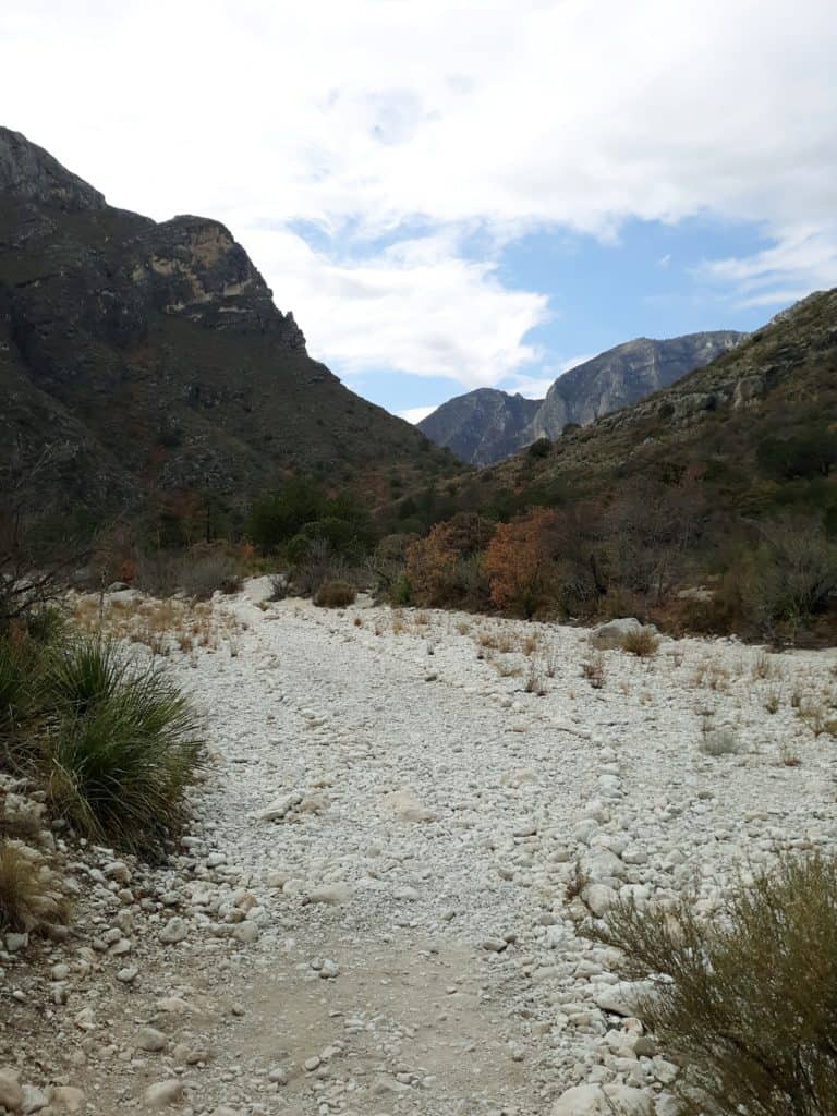
#3: The Devils Hall Trail
LENGTH: 3.8 miles roundtrip out and back
RATING: Moderate – Difficult
BEST TIME OF YEAR TO HIKE: Spring and Fall
ESTIMATED TIME TO COMPLETE: 2 hours
ELEVATION GAIN: 600 feet

Welcome to another one of Guadalupe Mountains National Park’s canyon hikes: the Devils Hall Trail. This shorter but moderately difficult hike passes through a rocky, narrow, “hallway”, with some minor scrambling and natural stairways, lending to its name. For a complete comprehensive breakdown of this hike, check out this comprehensive guide to the Devil’s Hall hike.
The Devils Hall Trailhead is shared with other popular hikes in the area, like the Guadalupe Peak Trail and El Capitan. Because it is a shorter hike, it is a popular “add on” option either before or after completing longer hikes in the park.

#4: El Capitan
LENGTH: 9 miles roundtrip out and back
RATING: Difficult
BEST TIME OF YEAR TO HIKE: Spring and Fall
ESTIMATED TIME TO COMPLETE: 4 – 7 hours
ELEVATION GAIN: 1,656 feet

For an uphill high desert hike, check out the El Capitan Trail, the neighbor of state high point Guadalupe Peak. In fact, just before summiting Guadalupe Peak, you can look down on top of the summit of El Capitan. El Capitan is easy to spot not only from the top of Guadalupe Peak, but also from simply driving past the park. It is the looming monolith that you will most easily recognize from the highway, and for that reason it has become an iconic symbol of the Guadalupe Mountains.
El Capitan is a little harder than Guadalupe Peak in technical terms, due to part of this challenging hike being considered “off trail” and requiring a bit of bushwacking navigation at times!


#5: Smith Spring and Manzanita Spring Loop Trail
LENGTH: 2.5 miles roundtrip loop
RATING: Moderate
BEST TIME OF YEAR TO HIKE: Spring and Fall
ESTIMATED TIME TO COMPLETE: 1 hour
ELEVATION GAIN: 393 feet

What makes the Smith Spring and Manzanita Spring Loop Trail one of the best hiking trails in Guadalupe Mountains National Park? It is a humbling reminder of life in the midst of the desert. In this case, desert springs that support this little oasis of desert animals, flora, and fauna. Much like the McKittrick Canyon Trail, the Smith Spring and Manzanita Spring Loop Trail surprises many hikers with its vegetated and lush environment, not to be outdone by the towering backdrop of the Guadalupe Mountains looming overhead. The Smith Spring and Manzanita Spring Loop are also a great “goldilocks” trail for those looking for a hike not too long, not too short, not too easy, and not too hard, with some interesting landmarks and scenery along the way.

#6: Pinery Nature Trail
LENGTH: 1 mile roundtrip out and back
RATING: Easy
BEST TIME OF YEAR TO HIKE: Spring and Fall
ESTIMATED TIME TO COMPLETE: 20 – 30 minutes
ELEVATION GAIN: 82 feet

The Pinery Nature Trail is a short and sweet trail, that is perfect for time crunched visitors, visitors with an interest in early frontier history, and visitors with young children. The Pinery Nature Trail is also the exception to the no pets rule – leashed pets are welcome on this trail.
Not only are there chances to learn more about the environment on this nature trail, but there is also one big historical highlight to witness – the remains of the stagecoach station ruins of the Butterfield Overland Mail Route, which operated in the Guadalupe Mountains in the 1850’s.


#7: The Bowl and Hunter Peak
LENGTH: 12.9 miles roundtrip loop
RATING: Difficult
BEST TIME OF YEAR TO HIKE: Spring and Fall
ESTIMATED TIME TO COMPLETE: 6 – 10 hours
ELEVATION GAIN: 3,169 feet

A challenging uphill climb through the rugged, exposed peaks of the Guadalupes, the Bowl Trail will take you en route to reaching Hunter Peak, via the Tejas Trail and Juniper Trail. This hike is a favorite among backpackers. It will definitely give you a workout, with some epic views! Just make sure to be physically prepared and equipped with necessary gear, as this is a very strenuous, exposed trail. Like Guadalupe Peak, this trail is filled with switchbacks. Unlike Guadalupe Peak, this trail is less trafficked, so you may have more solitude.


#8: Salt Basin Dunes Trail
LENGTH: 3.9 miles roundtrip out and back
RATING: Easy
BEST TIME OF YEAR TO HIKE: Spring and Fall
ESTIMATED TIME TO COMPLETE: 1.5 – 2 hours
ELEVATION GAIN: 42 feet

The Salt Basin Dunes Trail is unlike any other hiking trail, or region, in the park. For starters, it is very remote, located about a 1 hour drive from the Pine Springs Visitor Center, in the Salt Basin Dunes Day Use Area. This trail explores miles of sand dunes interspersed with fragile desert shrubbery. It is quite a stark difference from the majestic mountains located in the heart of the park.
If you are looking to get away from it all and enjoy the most peace and seclusion, this is probably the trail for you, as it is one of the least visited hiking trails in Guadalupe Mountains National Park. For those that make the effort though, it is an unforgettable perspective.
Note that unlike neighboring White Sands National Park, these sand dunes are not sleddable, and it is important not to venture into fragile areas.

Guadalupe Mountains National Park Camping
There are 2 developed campgrounds in Guadalupe, the Pine Springs Campground and the Dog Canyon Campground. Pine Springs contains 20 tent sites and 13 RV sites, while Dog Canyon has 9 tent sites and 4 RV sites. Pine Springs Campground, adjacent to the Pine Springs Visitor Center, is located in a largely desert environment at the base of Guadalupe Peak, with less shade and more wind. Dog Canyon, on the park’s north side, is located at a higher elevation and is more shaded and cooler in the summer, resting in the shadows of neighboring cliff sides. Its location also protects it more from the characteristic strong winds of west Texas. Pine Springs Campground is more centrally located, while the Dog Canyon Campground is more remote. Both developed campgrounds are reservable online HERE.
There is also the Frijole Horse Corral Campground available, just one mile outside of Pine Springs. This campground offers facilities for horse users.
There are restroom facilities in Guadalupe’s campgrounds, but no showers. There are also no campfires allowed park-wide, due to the consistent dry conditions. Campsites are $8 per night. But the unfiltered, unobstructed, starry night sky of west Texas is priceless.
Backcountry camping is allowed at Guadalupe Mountains National Park, but campers must obtain a permit in order to backcountry camp. Visit the park’s website for special instructions for obtaining a permit.
Other Top Things to Do in Guadalupe Mountains National Park
The outdoor opportunities of hiking and camping are the main attractions when it comes to the top things to do in Guadalupe Mountains National Park, but don’t overlook these other highlights.
- National Park Visitor Centers
There are 2 Visitor Centers in Guadalupe Mountains National Park: the Pine Springs Visitor Center and the McKittrick Canyon Visitor Center. The Pine Springs Visitor Center is the main visitor center and headquarters.
At the Pine Springs Visitor Center, you can view the museum exhibits, talk to rangers, pay entrance fees and pick up permits, and peruse the park store. At the McKittrick Canyon Visitor Center, guests can view some of the interesting outdoor exhibits.
- The Frijole Ranch Museum
Frijole Ranch is located just over a mile northeast of the Pine Springs Visitor Center. Exhibits here point to the early days of the Guadalupe Mountains, including Native American and early ranching history. You can also learn how this National Park was established, and witness the old schoolhouse and springhouse. There is also a picnic area and courtyard here available for use.
- Wildlife Spotting
Wildlife viewing is a popular pastime in these mountains, in particular bird watching. Thanks to the supportive water sources spread out across the park, like the Smith and Manzanita Springs, or McKittrick Canyon, there are several prime places to go birding. Various types of sparrows, mockingbirds, bluebirds, doves, woodpeckers, hummingbirds, and many more can be spotted. Overall, there are more than 300 species of birds that call the Guadalupes home.
In addition to birds, there are other unique natives to keep an eye out for. Mule deer are common, elk are a little harder to spot. Smaller mammals like jackrabbits, skunks, porcupines, and ringtails roam. Predators like mountain lions, coyotes, bobcats, black bears, and foxes are more elusive. There are plenty of reptiles to watch for in the form of snakes, some venomous, and lizards.
As always, regardless of the type of wildlife, it is important to respect them from a distance and never feed any resident animals. Support a healthy environment for all the Guadalupe residents by packing in and packing out.

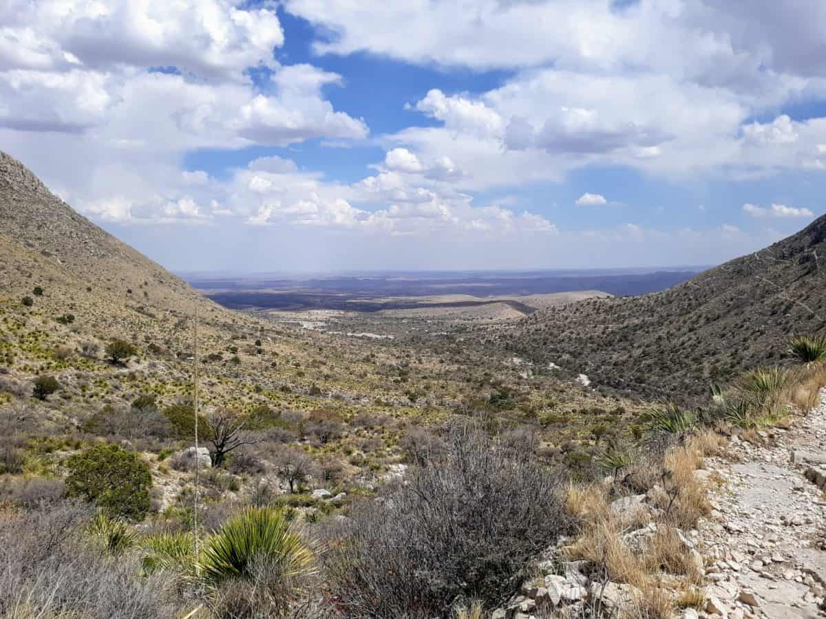
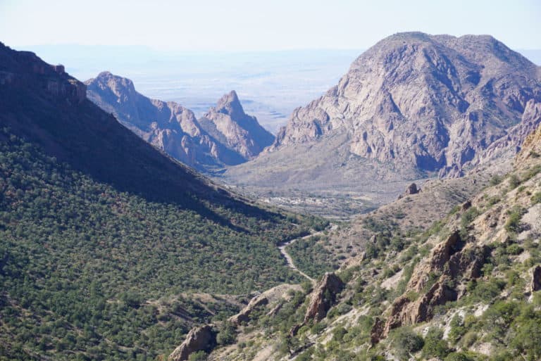
Views overlooking all of Guadalupe Mountains National Park
Want to Add on to Your Guadalupe Mountains National Park Visit?
Check out these other nearby outdoor adventures:
- White Sands National Park in New Mexico
- Carlsbad Caverns National Park
- The best hiking trails in El Paso
- Santa Elena Canyon in Big Bend
****So What’s Next After Guadalupe?
Visit Every Amazing National Park in the United States, with this National Parks Printable Checklist
Related Articles:
- Hiking Guadalupe Peak, the Highest Point in Texas (I have had the pleasure of hiking this peak multiple times – let me tell you why I keep coming back to this trail!)
- How to Explore BOTH Texas National Park in 4 Days!
- Where to Find Mountains in Texas
- The Best Hiking Trails in West Texas
- The Best Outdoor Things to Do in West Texas
PIN for LATER!


Looks Amazing! I am an East Coast girl myself, so I have never even heard of this park. But it definitely seems like it is worth the trip.