Hiking Black Mesa: The Highest Point in Oklahoma
The panhandle of Oklahoma might not be the first place that comes to mind when you think of superb mesa and plateau hiking, but there is one trail that makes this region of Oklahoma really stand out. The hike to Black Mesa Oklahoma, the highest point in Oklahoma!

Disclosure: Below are some affiliate links-these are all products I highly recommend. I won’t make any recommendations on this page that I haven’t tested or personally used! Enjoy this guide to hiking Black Mesa, the highest point in Oklahoma!
Table of Contents
Guide to Hiking Black Mesa Oklahoma
This corner of the Sooner State really melds the characteristics of the surrounding regions. To the northwest lies the famed topography and Rocky Mountains of Colorado, and to the south and east lie the open plains and grasslands of Oklahoma and Texas. What you find at Black Mesa is a taste of both of these unique geographies blended seamlessly together – the end of the Rocky Mountains melding into the plains of central America. Black Mesa Oklahoma is an expanse of hike-able grasslands and plains, bordered by a ridge of mesas, vistas, and plateaus. It is a unique one among the 50 U.S. state high points!
This guide to hiking Black Mesa includes:
- Location of Black Mesa Oklahoma
- Background on the Park
- Overview of the Black Mesa Trail
- Full Trail Report
- Gear Recommendations for Hiking Black Mesa

Black Mesa State Park and Black Mesa Nature Preserve
The state park and nature preserve that house Black Mesa Oklahoma, are actually two separate entities, approximately 15 miles apart. The hike to the highest point in Oklahoma, atop of Black Mesa, is found on the Nature Preserve part.
Black Mesa State Park is adjacent to Lake Carl Etling, and offers campsites for overnight guests. Black Mesa Nature Preserve is open from dawn to dusk only, and there is no camping within the Nature Preserve borders.
What is unique about this area, and the Black Mesa hike, is that it is THE point where the Rocky Mountains of the west meet the central prairie grasslands. Unique wildlife can be found here, with western dwelling species at their most eastern reaches, and eastern dwelling species at their most western reaches. Black Mesa Oklahoma is home to eagles, quail, black bears, bobcats, mountain lions, mule deer, antelope, and big horn sheep. It is a perfect blending of geographies, environments, and ecosystems, and it is what makes this area very unique. A hike up Black Mesa Oklahoma not only allows you to check off a state high point hike, but it gives you first hand experience of what this symbiotic blending of United States topographies looks like up close.

Location of Black Mesa Oklahoma
Black Mesa Oklahoma is located literally only minutes from the Colorado and New Mexico borders, in far northwestern Oklahoma. The nearest small town to the Black Mesa trailhead is in Kenton, Oklahoma. Black Mesa State Park is located a short distance south of the Black Mesa Nature Preserve, where the hike to the highest point in Oklahoma is located.
Map of Black Mesa Oklahoma and the surrounding area
Quick Facts on Black Mesa Oklahoma
- Length: 8.5 miles out and back roundtrip
Black Mesa Trail from trailhead to summit
- Elevation: 4,973 feet
- Elevation Gain: 743 feet

- Rating: Moderate, due to some incline and length of trail
- Estimated Hiking Time: 2.5 – 3.5 hours
- Best Time of Year to Hike: spring and fall
- Pet Friendly: Yes to leashed pets, if your pet is conditioned to hiking long distances
- Fees / Park Hours / Facilities: There is no fee to hike the highest point in Oklahoma! The preserve is open daily from dawn til dusk. Parking is available at the trailhead, and there is a restroom as well. There is no camping allowed along the trail. The location of this park and hike is very remote. Fill up with gas, food, water, etc., before arriving.
Full Trail Report for Black Mesa Oklahoma
The Black Mesa Trail is not a trail that is going to garnish a lot of recognition or renown. It is in a very remote corner of an under-rated state, when it comes to outdoor opportunities and hiking. But as I said before, this is such a unique region due to the worlds of central grasslands and Rocky Mountains clashing, that it is a fascinating and enjoyable hike.
Even though Oklahoma may not be known as a “diverse” hiking environment, this hike accomplishes just that. There are sections of flat terrain traversing grasslands, sections of uphill ascent, and sections of wide open expanses walking on the face of the plateau. Once you reach the top, you will easily see how these high point views can be quite impressive, even from a humble contender like Oklahoma. There is nothing else for miles around, and odds are you can have this trail mostly to yourself for the majority of your hike. On the day of my hike, I encountered two other individuals in just over three hours.

Trailhead of the Black Mesa Hike
The trailhead for the Black Mesa hike can be found in the Black Mesa Nature Preserve, in the very northwest corner of the state. There is no cost to enter the Nature Preserve and hike Black Mesa. There is a wooden sign marking the small parking area and a single toilet facility at the trailhead. Be sure to pack in all the water you will need for your hike. I would plan on bringing 3 liters minimum for this day hike, especially in the summer. There is almost no shade along this trail, especially during the later part on the top of the mesa.
There is a sign for the trail and a gate at the trailhead. The initial part of the trail starts off open and flat, through a largely grassland environment, bordered by a ring of plateaus and mesas.
I like to break the Black Mesa hike into 3 distinct parts: the valley section, the ascent, and the mesa section.
The Valley Section of the Black Mesa Trail
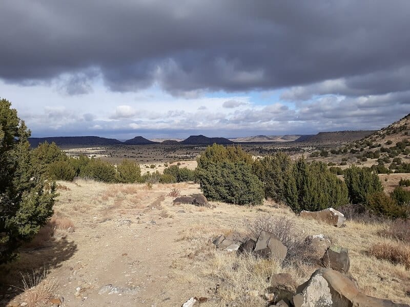
The valley section of Black Mesa Oklahoma is the initial 2 miles of this hike. This is the part of the trail that speaks to the central grasslands characteristics of this region. Bordered by level plateaus, this valley section passes along mostly flat land, with easy, un-obstructed viewing into the distance for miles. The trail is well marked and easy to follow.

The Ascent Up Black Mesa
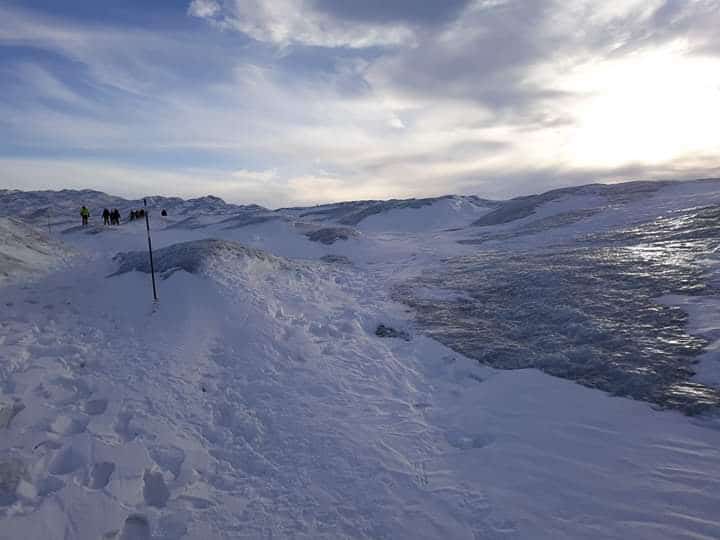
Just after Mile 2, the trail veers to the left, narrows, and begins to proceed up the side of Black Mesa. This part of the trail is a little more uneven and rocky, one can assume from washout and wind due to its exposed location, and as such it requires a bit of navigating your footwork up the trail, but the ascent does not take long. At a quick pace, it is only a 5 or 10 minute ascent. The path is moderately steep here, but consistent, and the open mesa views over the valley off towards the right are breathtaking!

The Mesa Section of the Black Mesa Trail
Mile 4 occurs largely after making the ascent up the mesa. This is the first state high point hike I have completed where the summit was not immediately after the uphill climb. Here at Black Mesa, it is like entering another world at the top. Once you finish the ascent, the mesa opens up completely, filled with more prairie grasses. At this point, hikers have just around 1 mile left to the state high point marker on the top of Black Mesa Oklahoma. You can get a good idea of what this portion of the hike is like from the visual presented in the elevation chart below:
Black Mesa Elevation Chart
The “Summit” of Black Mesa
The summit of Black Mesa is completely open and flat, surrounded by grasslands – not your traditional mountain peak summit! Had you not climbed the side of the mesa, you would have no idea that you were standing on the highest point in Oklahoma. There are no real panoramic views here, those occur mostly as you ascend on Mile 3. In fact, the best place to stop and take panoramic pictures would be along the climb up to the mesa, just before reaching the top of Black Mesa. The summit at the top of the mesa, while not blessed with lofty views necessarily, is peaceful and beautiful in its own way, surrounded by whispering prairie grasses.
Because this is a completely un-obstructed location, sitting high atop a flat mesa, it can get extremely windy. In fact, this might be the most windy hike I have ever completed out of all the U.S. state high points I have climbed so far, including some of those other higher elevation state high point hikes like:
- Wheeler Peak in New Mexico
- Mt. Whitney in California
- Oregon’s Mt. Hood
- Utah’s Kings Peak
- Humphrey’s Peak in Arizona
- Nevada’s Boundary Peak
- or Guadalupe Peak in Texas
The state high point marker for Black Mesa is a four sided column structure, with each side labeled direction-ally with its corresponding state that it faces. There is also a small Oklahoma state flag at the base, and a green container for hikers to sign in and log that they were there. Unfortunately, I simply could not get the box to open for me, so hopefully this issue has long been remedied for subsequent visitors to Black Mesa Oklahoma.


Descending Black Mesa
The descent down Black Mesa is much quicker than the ascent up. The second half of the Black Mesa hike is either flat or downhill. The descent down the mesa was when I first really took the time to appreciate just how unique this area is, and the fact that you really can see so much from that vantage point!

Recommendations for The Highest Point in Oklahoma
- bring sun protection, whether that is sunscreen, hats, or both preferably! There is almost zero shade hiking the Black Mesa Trail. The good news is there is very little to block the views so you can see far into the distance, the downside is the sun can get strong, especially in the summer!
- bring plenty of water! There are no facilities in which to fill up with water, so pack in what you need for the hike! Check out my favorite hiking water bladder, that I use for all my day hikes. I love this water bladder because the wide mouth makes cleaning, drying, and filling super easy!
- bring a wind resistant jacket, especially in the winter! Because this is such an open, flat, un-obstructed hike, the wind can really whip here, especially up top on Black Mesa. I love my Outdoor Research Helium II jacket, because it is super lightweight (only a couple ounces) so great for daypacking, it compresses down super small, and is FULLY waterproof AND windproof. It is not insulated, so in the colder months, you will want to layer underneath with a base or mid layer, like my favorite wool layer here.
- Bring a stick of Chap Stick as well, otherwise the wind is likely to cause havoc on your lips!
- make sure you stock up on gas and whatever water and snacks you need before. There are no major facilities or towns in the immediate vicinity of Black Mesa Nature Preserve. Your best bet is to stock up in Kenton, Oklahoma, before departing for your hike.
- I would not consider this a overly challenging hike, but it is on the longer side of day hikes at 8.5 miles roundtrip. Black Mesa Oklahoma is also located in a remote area, and is sparsely visited in comparison. Though the trail is clearly marked in its entirety, due to the length of this hike, I would recommend bringing the 10 hiking essentials, in a suitable day pack, like the Camelback Helena 20 Crux daypack I use for my day hikes
****Download your own day hiking essentials checklist HERE!
- for a hike like this that is mostly flat, I would not say that a hiking boot is a necessity, but at least plan to hike in something with a sturdy grip, such as a good trail running shoe like my HOKA One One Speedgoats that I both hike and trail run in. I LOVE these trail runners – they are unmatchable in terms of cushioning, and they leave your feet feeling “fresh” even after hiking all day long! These trail runners have gotten me through some beasts of day hikes, like the Grand Canyon’s Rim to Rim hike, or the 21 mile long hike up Mt. Whitney, the highest point in the lower 48 states!
- Your shoes are only as good as the performance socks you pair with them! Get a successful pairing with these Hilly Twin Skin socks! I live in these performance socks, on all my hikes and long distance trail runs. I used to be extremely blister prone, but not since discovering Hilly Twin Skin socks! The “twin skin” layers prevent the friction that can be the cause of blisters.

Other Attractions Near the Highest Point in Oklahoma
- Black Mesa State Park is renowned for its dark skies, and boasts some of the blackest, most un-obstructed evening panoramas in the country. It is a popular camping location, especially in August during the annual Perseid meteor shower. Both RV and primitive tent campsites are available at Black Mesa State Park. It is an ideal place to spend the night after a day hiking Black Mesa Oklahoma. Follow this link to reserve a campsite online.
- For those interested in visiting three states simultaneously, you can easily do so as an add on to any visit to Black Mesa Oklahoma. Only a short drive away, you can visit the three states of Oklahoma, New Mexico, and Colorado at the same time located at the Preston Monument Tripoint!
- For fossil lovers, a visit to Clayton Lake State Park in northeastern New Mexico should be on your list! A very impressive collection of several hundred dinosaur tracks, made by eight different species of dinosaurs, can be viewed at this state park, as well as camping, hiking, boating, and fishing. Follow this link to book a campsite at Clayton Lake State Park.
Curious About Your Own State High Point? Or How ‘Bout All 50 of Them?
Grab your FREE graphic with All 50 State High Points in the U. S. HERE!
PIN for LATER!


My 12 yr old son and I hiked this trail on a Sunday late afternoon (7/11). Definitely no shade and the sun in our face for the 1st part of the hike. Thanks to whomever left the “emergency water” tub b/w miles 2 and 3! We encountered only 2 others on the trail. We did see some spiny lizards, giant grasshoppers, and even a rattlesnake posing for us. It was a nice way to begin our 4 day getaway!
Hi Michael,
Black Mesa really surprised me when I hiked it. I actually had a different experience from you, because I hiked it the end of November, and actually encountered freezing temps and light sleet and snow! So shade and sun were not the issue for me that day, but you are right, there is very little shelter, cover, or wind resistance on Black Mesa. But I loved the views, and loved seeing that part of the country where the plains get ready to meet the Rockies! Definitely a unique part of Oklahoma, and a surprisingly intriguing high point hike! I did not see any of that wildlife that you saw, I’m a bit jealous of that. I actually enjoy spotting native snakes and identifying them when I can! Glad you made it safely!