Hiking White Butte: The Highest Point in North Dakota
Make all the jokes you want about this state high point’s humorous name, but this short, spunky trail packs a surprising punch in a remote and beautiful section of the northern United States! Skewing slightly north from the infamous Badlands terrain of South Dakota, this state high point borrows the same butte, vista, and mesa trends found across the Dakotas and sprinkles them around the summit of White Butte North Dakota, the highest point in North Dakota!

Overview of the White Butte Hike
- Length: 1.3 miles roundtrip out and back roundtrip
Trail route for White Butte North Dakota, from the trailhead to summit (note that the exact length may not be updated in Google Maps to show the newly renovated parking area / start of the hike, but is still helpful in locating the trail)
- Elevation: 3,507 feet
- Elevation Gain: 334 feet

- Rating: Moderate (this hike is short but surprisingly challenging in brief, steep spurts)
- Estimated Completion Time: 1 – 1.5 hours
- Best Time to Hike: Late spring – early fall
- Pet Friendly: Yes
- Parking / Facilities: there is a small parking area located by the trailhead. There are no bathrooms.
- Fees: Free, but donations are welcome
- Other Tips: the area is known for rattlesnakes, so pay attention to your footing and keep your eyes and ears open, especially if hiking with pets or small children!
The White Butte hike is unique in that it is located on private land. The owners of this land do allow hikers to come conquer this state high point summit. There is no fee to hike White Butte South Dakota, but there is a red mailbox at the entrance in which visitors can leave a donation.
The rural farm road leading in to the trailhead for White Butte has been greatly renovated recently. Previously, the parking area was an additional 2 miles roundtrip away from the actual trailhead, and you had to hike in along a deeply rutted dirt road to reach the entrance gate at a cattle fence, and the actual start of the White Butte Trail. Now, there is a parking area right at the trailhead, and there is good signage leading in to the parking area and trailhead. Some hiking apps, like AllTrails, still show White Butte as having a roundtrip length of 3.4 miles, but that is outdated. Now that you can park and start right at the trailhead, the roundtrip length is 1.3 miles.
To reach the trailhead, you will drive on several farm roads, following the posted signs, passing by the old parking area, and continuing on until you pass an old dilapidated farm building on the right hand side, before arriving at the new parking area and official trailhead of the White Butte hike. The trail head is marked by a fence and a gate. Make sure after passing through the gate that you close it behind you, as there are cattle present on the land. And don’t forget to leave a donation!
Location of White Butte North Dakota
The White Butte hike is located in the southwestern corner of North Dakota. It is a very remote, secluded state high point to locate and hike, and requires driving down small, rural, farm roads. The nearest city to White Butte North Dakota is Bowman, North Dakota. White Butte is located just a short drive south of Theodore Roosevelt National Park, which makes for a great add on to this state high point hike.
Map of the area surrounding the highest point in North Dakota
White Butte Trail Report
The White Butte Trail officially starts after passing through the gate located at the trailhead. Initially, the trail leads through some sandy gulches at the base of the butte, and is a little difficult in some spots to find. Keep in mind that if you lose the trail, you want to keep to the left and look for the spot at the base of the butte where the trail begins to ascend.
Once you begin the ascent, the sand disappears and tall North Dakotan grasses take their place. Though this trail is short, it is surprisingly steep in some sections, coupled with no shade. This can make for a challenging environmental factor, especially in the summer.
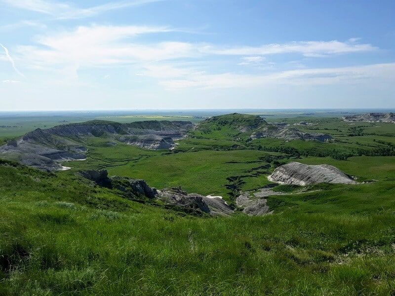
The ascent of White Butte continues up and along the ridge of the butte, until reaching the flat top of the butte.

The flattened top of White Butte packs a surprising punch in terms of views! From this vantage point, you can see a full panorama of rural North Dakota’s grasslands and butte topography, and maybe even some local cattle! These views also come with a side of peaceful seclusion and quiet, and I can almost guarantee you will have this hike and summit views to yourself!

Recommendations for Hiking White Butte North Dakota
- the grasses are tall here at White Butte, so I would recommend wearing a suitable pair of hiking pants, like these durable and breathable Columbia hiking pants that I wore.
- there are some short spurts of steep, uneven grades here at White Butte, so I would recommend a good trail running shoe, like my favorite HOKA One One Speedgoats that I hike in.
- pair your shoes with the best performance socks – Hilly Twin Skin socks! I used to be extremely blister prone before discovering these socks, and now haven’t had a single blister since switching, even on all day long grueling hikes like the Grand Canyon’s Rim to Rim hike! The “twin skin” in these socks is what helps to prevent the friction that can cause blisters.
- this might be a short hike, but you will want water nonetheless, especially in the summer when the sun can be surprisingly strong! It may not be necessary to carry a ton of water, but I would still recommend a full water bottle’s worth at least. You can go with a water hydration bladder like this one I use on all my hikes, paired with a daypack, like my favorite Camelbak Helena 20 daypack. Or, you can opt for a little more minimal approach for this short hike, like this hydration waist belt equipped to carry a water bottle and small personal items. It is perfect for carrying water, keys, and a phone!
- in the warmer months, protect yourself from the sun with proper sun protection, including sunscreen, Chapstick, and a head covering.
- leave a donation so the owners can continue to allow high pointers to check off the highest point in North Dakota from their list for a very minimal cost
- the trail is hard to locate in certain spots, and can be a little hidden by the sandy washout sections and the tall grasses. Use a good hiking app, like AllTrails, to ensure you stay on the correct trail
Other Attractions Near White Butte North Dakota
- If you want to knock out both Dakota state high point hikes, you are in luck because they are only a couple hours apart! Black Elk Peak in South Dakota is a longer day hike, but definitely worth it! Check out my post on hiking Black Elk Peak in South Dakota, including how to see the famed Cathedral Spires!
- Take an epic road trip through neighboring sister state South Dakota, and check out both of South Dakota’s twin National Parks!
- Only a short drive north from White Butte North Dakota is North Dakota’s only National Park, Theodore Roosevelt National Park. There are some great hiking opportunities here, as well as a scenic park drive from which you can view plenty of wildlife, including deer, bison, wild horses, and prairie dog towns!
Read More: Interested in some other mesa-esque hikes out there, similar to the highest point in North Dakota? Check out the Black Mesa Trail in Oklahoma, the 8.5 mile long state high point hike where the Rocky Mountains of the west meet the central plains and grasslands!
RELATED ARTICLES:
- Learn about ALL 50 U.S. State High Points HERE!
- The Twin National Parks of South Dakota
- Black Elk Peak: The Highest Point in South Dakota
Are You Ready to Conquer Some Other State High Point Hikes?
Grab your FREE State High Point Graphic of ALL 50 States!
PIN for LATER!