Hiking Mt Rogers Virginia: the Highest Point in Virginia
Hiking Mt. Rogers, Virginia, offers something for everyone! The epic highlands of southwestern Virginia, a deep hold to the Appalachian Trail and its hikers, bands of wild ponies, and of course, the highest point in Virginia! The region surrounding the Mt. Rogers hike is reminiscent of other notable highlands from around the globe, but with its own unique Appalachian flair! This guide will cover all aspects of how to get the most out of your Mount Rogers hiking experience!

Disclosure: Below are some affiliate links-these are all products I highly recommend. I won’t make any recommendations on this page that I haven’t tested or personally used! Enjoy this guide to hiking Mt Rogers Virginia!
Table of Contents
Hiking Mt Rogers Virginia
Hiking Mt. Rogers, Virginia, is genuinely one of my all time favorite hiking destinations! This lengthy and enjoyable day hike turned out to easily be one of my favorite state parks in the country, and one of my top favorite (out of the 45 I have completed to date) state high point hikes in the U.S.!
This guide to the Mt. Rogers hike will cover the following:
- Location of Mt. Rogers, Virginia
- What to Know Before You Go
- Overview of the Mt. Rogers hike
- Full Trail Report
- Recommendations for hiking Mt Rogers Virginia

Location of the Highest Point in virginia
This breathtaking, yet humble, highest point in Virginia, is located in the southwestern corner of the state, just 30 minutes or so away from one of the most beloved “trail towns” on the Appalachian Trail, Damascus, Virginia. The Mt. Rogers hike itself is actually located almost entirely along the Appalachian Trail itself, in Grayson Highlands State Park.
Location of the Mt. Rogers hike
Know Before You Go
*This guide will cover certain specifics of hiking Mount Rogers Virginia. Take into account that there are other ways and routes to summit Mt. Rogers, but this guide will cover how to do so as a day hike, and starting and finishing at the Massie Gap Trailhead within Grayson Highlands State Park.
ENTRANCE FEES / HOURS: entry into Grayson Highlands State Park are $10 per vehicle on weekends from April – October, and $7 otherwise. The park itself is open 8am – 10pm, but if arriving before, you can self pay with cash through the envelope system at the entrance booth. The park office is open Monday – Friday 9am – 4pm.
PARKING: There is a designated overnight/backpacking parking lot for overnighters, and that is $15 a person and requires a reservation. For the purposes of this day hiking guide, it will not be necessary to obtain a reservation, and you would not park in the “overnight lot”, but in one of the 150 parking spots at the Massie Gap Trailhead for day users.
BEST TIME OF YEAR TO HIKE MT ROGERS: the Mt Rogers hike can be completed year round, though winter may see some cold weather and snow that could affect trail conditions.
PERMITS / RED TAPE: permits are not required for day hiking Mount Rogers, only a paid entry fee.

Quick Facts on the Highest Point in Virginia
Length: 10.5 miles out and back roundtrip
Route from the trailhead to the highest point in Virginia!

Elevation: 5,729 feet
Elevation Gain: 1,755 feet

Rating: Moderate
Dog Friendly: Yes
Estimated Time to Finish the Mt. Rogers Hike: 3.5 – 5.5 hours
Best Time of Year to Hike: March – October, though technically, all seasons are doable for Mt. Rogers. Spring and fall are pleasant, summer may be a tad hot during the height of the day, but should be completely bearable. Winter will be cold and come with winter weather, but layering correctly and watching for hazardous winter weather ahead of time should suffice.
Entering the State Park and Accessing the Trailhead: Grayson Highlands State Park is open year round. There is a $7 entrance fee, but it is $10 on weekends from April – October, due to peak season. The park opens at 8am, but if arriving earlier (and I would, especially in peak season), you can self pay. Access the trailhead at Massie Gap, directly in front of the day use parking spots. There is an overnight parking lot at the Overnight Backpackers Lot (reservations required), but you will want to use the day hiking spots. There is overflow parking as well at the Visitor’s Center, just a short walk away from Massie Gap. The trailhead for the Mt. Rogers hike (Massie Gap) is well marked. Follow the Appalachian Trail past Wilburn Ridge, the Thomas Knob Shelter, and continuing on the spur trail to the “summit” of Mt. Rogers, Virginia, the highest point in Virginia!

The Trailhead for Mt. Rogers Virginia
To start hiking the highest point in Virginia, you will need to enter Grayson Highlands State Park, and proceed to the Massie Gap Trailhead. This trailhead does show on AllTrails and Google Maps, though cell service was spotty for me as I got near the park, and it is best to familiarize yourself with how to get to the parking lot at Massie Gap beforehand. After entering the park, the Massie Gap Trailhead and parking lot will be on your right hand side in just a few short minutes.
*There are 150 spots for dayhikers at the Massie Gap Trailhead parking lot. I would recommend getting there early, especially on a peak season weekend. The park entrance booth is manned at 8am when the park opens, but it is totally doable to arrive earlier and self pay with cash at the entrance booth.

The parking lot for the Massie Gap Trailhead overlooks a large clearing initially, with visible fencing just slightly in the distance, indicating the start of the trail (which is the Appalachian Trail). Pass through the gate, making sure to close it behind you, to start hiking Mount Rogers, Virginia, along the historic Appalachian Trail!
*The Mt. Rogers hike is almost entirely along the Appalachian Trail (about 9.5 miles of the 10.5 total mileage), but the last half mile to the summit of Mt. Rogers is actually a spur off of the Appalachian Trail.
Full Trail Report on Hiking Mt Rogers Virginia
Once you get started past the entrance gate, you should notice one of the most helpful aspects of this hike, the tell tale white blazes that indicate the Appalachian Trail. Before hiking Mount Rogers myself, I had read that trail finding was difficult for some, but I did not have that experience at all. The white blazes were easy to follow, if and when in doubt.
Considering that almost this entire hike is on the Appalachian Trail, I found it very easy to just make sure that I was following the white blazes that indicate the Appalachian Trail, and they are literally plastered on rocks and trees about every 30 seconds along the trail. It’s true that there are some other intersecting trails, like the horse trails and Rhododendron Trail near the beginning at Massie Gap, but just follow the white blazes and plentiful signage for both the Appalachian Trail and the Mt. Rogers summit!


Hiking Mt. Rogers, Virginia, is one of the most peaceful, fun, and mesmerizing hikes I have completed. I simply had an absolute blast on this hike, from the scenery, to the wildlife, to the Appalachian Trail characteristics and chatting with other hikers, including some AT thru hikers and section hikers – it was all so engaging! Out of the current 45 U.S. state high points I have hiked, this hike is in my top 3!
***Curious what my top 3 state high point hikes are?
- Kings Peak, Utah
- Mt. Whitney, California
- and, Mt. Rogers, Virginia!
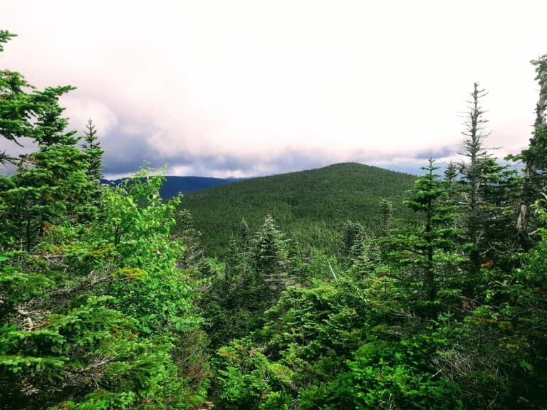
On the particular May morning that I hiked Mt Rogers, the clouds were hanging low and heavy in the sky, adding to the mood of being in some remote, mysterious, and secluded highlands. There is so much green here, and it is absolutely stunning when the sun breaks through the clouds on the dappled vegetation!


There are some brief sections of tree cover, but for a large part of the hike, you are on open trail, just trekking through the rolling hills. There are some minor rock slabs to traverse as well, and even a narrow rock “hallway” you can squeeze through along the trail (or go around and bypass if enclosed rock “hallways” aren’t your thing). The elevation gain here is spread out over such a lengthy distance, so it is very manageable, with only a few brief stints that will get you breathing hard. The length itself will be the most challenging part, not the elevation gain or grade.
Another thing to expect along the Mt. Rogers hike, is the chance to run into thru-hikers and section hikers of the Appalachian Trail, especially during peak season. The ones I met in particular were gracious and friendly, and a joy to chat with! Later in the day, you may find yourself running into more day hikers and families, especially closer to the beginning of the hike (not many families with young children will make it all the way to the “summit” of Mt. Rogers), but early in the morning seemed to be when I ran into the “die – hards” hikers!
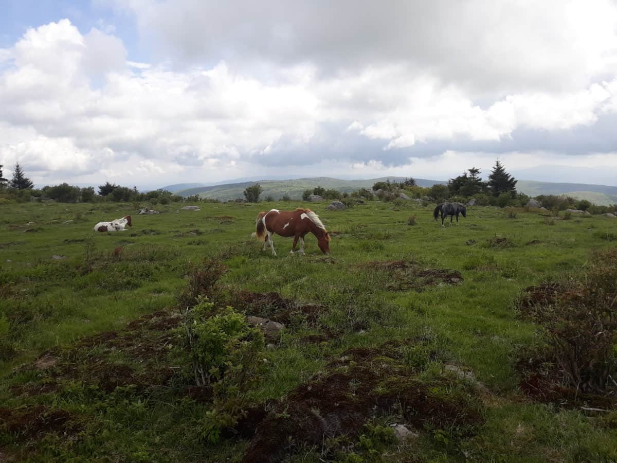
The other thing you will most likely encounter while making your way up to the highest point in Virginia are the iconic Grayson Highlands State Park wild ponies. The ones I met were not quite giving off that strong of a “wild” vibe, but even so it is important to appreciate them from afar and not feed them! Some of them were actually “parked” right off the trail, which led to some pretty cool close up pictures, while not actually physically interacting with or feeding them.


The Summit of Mt Rogers Virginia
Once you pass the Thomas Knob Shelter, one of the shelters in place for Appalachian Trail hikers, you will not be far from the spur trail that will branch off from the Appalachian Trail and take you the rest of the way to the summit of the highest point in Virginia!
As previously mentioned, the actual summit of Mt. Rogers, Virginia, is located on about a short half mile spur trail off the Appalachian Trail. It is completely enclosed in forest, with no panoramic views, so it is not your traditional summit. In fact, the summit is arguably the most forested part of the whole hike. But do not let that deter you from making it all the way. This section of hiking Mount Rogers was one of my favorite parts!


The forest here is dripping with moss, and has a heavy and almost mystical feeling to it. After enjoying several hours of hiking out in the open among the lush Virginia hills, this part of the trail felt completely different and unique!
The summit itself and the exact location of the highest point in Virginia is somewhat hard to locate initially, as the trail kind of peters off, right in front of a small clearing amongst the thick trees, surrounding a clump of large boulders. It is on this clump of large boulders that you will find a small marker implanted in the rock surface, indicating the highest point in Virginia!


Finishing the Mt Rogers Hike
Proceed out the way you came in. Half mile down the Mt. Rogers summit trail, back to the Appalachian Trail, and back towards Massie Gap and the parking lot, while following the white blazes. Enjoy the views, and the ponies, for as long as you wish!

Recommended Gear for Hiking Mount Rogers
There are a few must haves I would recommend bringing along for this day hike of Mt. Rogers, Virginia.
Recommended Gear Quick Links:
- Hoka One One Speedgoat Trail Runners
- Hilly Twin Skin Socks
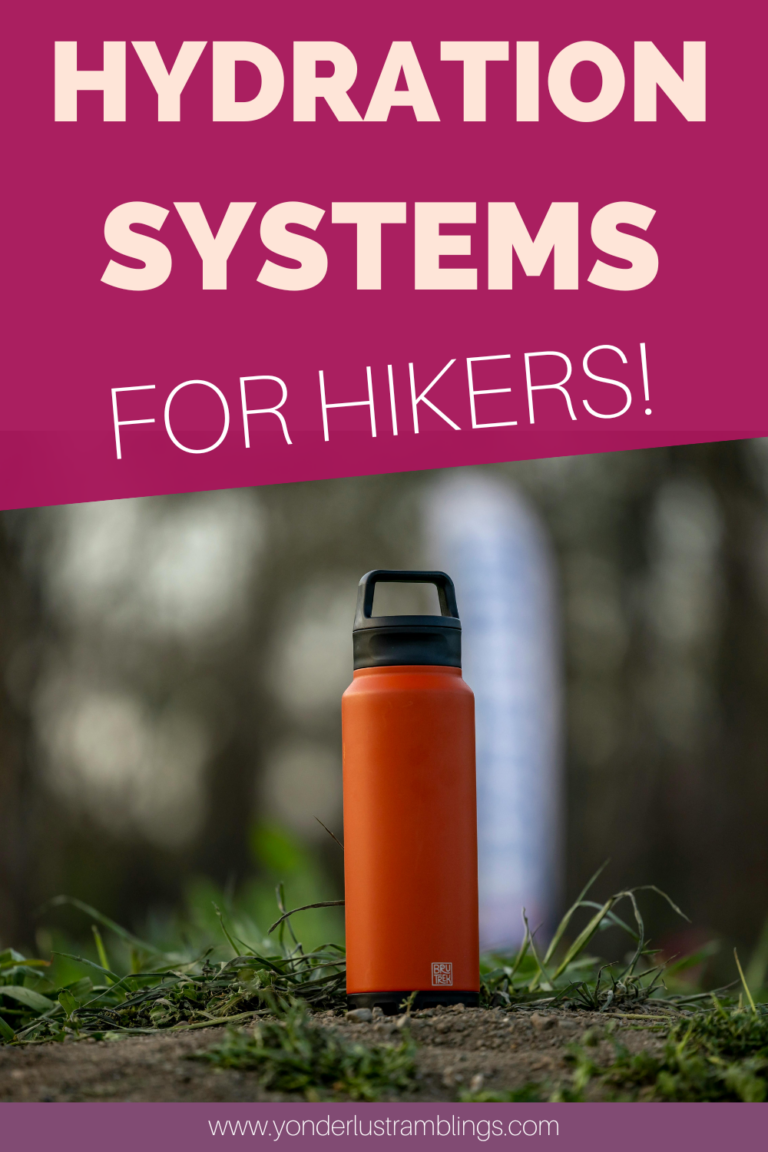
- Camelbak Women’s Hydration Vest
- Hydration Vest Water Bottles
- Outdoor Research Helium II Ultra-lightweight Waterproof and Windproof Jacket
- SOL Bivy
- Camelbak Women’s Helena 20 Daypack
- Platypus Water Hydration Bladder
Now let’s take a deeper dive at recommended gear!
Shoes! The trail here is generally straightforward, with not any big tricks up its sleeve. On long day hikes like these with only moderate elevation gain, I prefer to hike in trail runners, as they are lightweight and help me keep my feet feeling a little “fresher” over the long miles. My go to’s are my HOKA Speedgoats – unbeatable cushioning with these!
Socks! Your shoes are only as good as your socks. Not carefully selecting either will derail your hike quicker than anything, should you encounter blisters. I tend to be very blister prone, especially when hiking all day! What saved me were these lined socks – Hilly Twin Skin socks! These socks come with a liner in them, which drastically reduces the friction that was causing my blisters. Blister free since switching to them, on hikes from 1 mile to double digits!
Daypack/Hydration Vest! You could go with either of these and be okay on this hike, depending on your preference. I knew from the moderate take on this hike and the gentler elevation gain, that I would probably find myself breaking out a bit of my running background and incorporating a bit of trail running along my way to the top of Mt. Rogers, Virginia. I went with my Camelbak hydration vest for this hike – its flush design is perfect at eliminating bouncing when running or jogging, and it comes equipped with a wide mouthed 1.5 liter bladder that is easy to clean and dry, as well as several pockets with just enough storage to bring along the necessities needed for a moderate day hike: Chapstick, snacks, an extra pair of my Hilly Twin Skin Socks, a handheld water bottle for backup, my waterproof and windproof super lightweight Helium II jacket, my emergency SOL bivy, my keys, and my phone.
***What snacks do I carry for a day hike like Mt. Rogers?
- RX Bars
- GU Energy Gels
- Honey Stinger Waffles
- Squeezable Peanut Butter Packets
- Applesauce Pouches
- Beef Jerky
- Trail Mix
- Tuna Packets
If you opt to go with a daypack, a perfect size for this hike would be the other pack that I frequently use for more standard hiking day hikes, my Camelbak Helena day pack. With this pack, you can use a water hydration bladder like this Platypus model, that will fit comfortably in the Helena. I love this model of Platypus bladder because the wide mouth makes filling, emptying, cleaning, and drying much simpler!
 Now you are ready for the Mt. Rogers hike!
Other Outdoor Adventures Near Mt. Rogers, Virginia
After hiking Mt. Rogers, don’t miss out on some of the other outdoor opportunities nearby!
- Damascus, Virginia – known as the main “trail town” on the Appalachian Trail. You must pay a visit to this idyllic little town, even if it is just to stop in and grab a quick cup of coffee! It is just part of the Appalachian experience!
- Whitetop Mountain – a nearby neighbor of Mt. Rogers. Hiking this peak will have you knocking out the TWO highest points in Virginia.
- Shenandoah National Park – while it is a bit of a drive (4 hours), if you can swing it, adding on a stop at this National Park is a must! The same Appalachian Trail runs through the heart of Shenandoah National Park. If you only have 1 day to spend out Shenandoah, check out my personalized 1 day Shenandoah National Park Itinerary HERE! It includes stops at some of the best hiking trails in Shenandoah, including:
- George Washington and Thomas Jefferson National Forest – another great add on with TONS of hiking opportunities in a beautiful National Forest setting, in the heart of Virginia!
-
-
- Read More: So what’s the difference between a National Forest and a National Park anyways?
-
***Got More Hikes Planned? Be ready for them all with this Day Hiking Essentials Checklist!
Download Your Own Day Hiking Essentials Checklist HERE!
***Hiking Mt Rogers Virginia was state high point hike #39 of 50 for me! If you’ve ever been curious about “high pointing”, check out all 50 U.S. state high points, and don’t forget to grab your U.S. State High Points Download Here!
PIN for LATER!