The Guadalupe Peak Hike: The Highest Point in Texas
Most people have probably never heard of Guadalupe Mountains National Park. I live in Texas, and I was not aware of it until I was older, when I began to explore more of my home state. This National Park hides in an obscure little nook of west Texas, just outside the Texas city of El Paso, and the New Mexico city of Carlsbad. The best thing about this National Park though, is that it is inconspicuously hiding a big claim to hiking fame! It is the home of the highest point in Texas, the Guadalupe Peak Trail! In my quest to hike all 50 U.S. state high points, I could not have chosen a better one to start with than the state highpoint hike in my native Texas, the tallest mountain in Texas, the Guadalupe Peak hike!

Disclosure: Below are some affiliate links-these are all products I highly recommend. I won’t make any recommendations on this page that I haven’t tested or personally used! Enjoy this guide to the Guadalupe Peak hike, the highest point in Texas!
Table of Contents
Guide to the Guadalupe Peak Hike
Get all the info you need on the challenging and stunning Guadalupe Peak hike, from someone who has hiked to the highest point in Texas multiple times!

Location of the Guadalupe Peak Hike
The trailhead for the Guadalupe Peak hike is located in Guadalupe Mountains National Park in far west Texas, adjacent to the Pine Springs Visitor Center and Pine Springs Campground. Visitors will enter the park from Highway 62.
***Looking for lodging for your visit to Guadalupe Mountains National Park and Guadalupe Peak? Carlsbad is going to be your best bet for multiple options of lodging accommodations and amenities! While in Carlsbad, be sure to check out:
- These 8 outdoor adventures in Carlsbad
- Carlsbad Caverns National Park
- The Natural Entrance Trail in Carlsbad Caverns
***If you are ok with smaller accommodations with less amenities – it’s a little off the beaten path, but you can also check out Whites City, New Mexico, for lodging. It is conveniently located about 30 minutes from Guadalupe Mountains National Park (and at the entrance of Carlsbad Caverns National Park for those that want to knock out 2 National Parks in one trip!).
Map of Guadalupe Peak Hike and surrounding area
Background on Guadalupe Mountains National Park
Guadalupe Peak is indeed the highest point in Texas, topping out at 8,751 feet in elevation. It towers over its 40 mile long mountain range, the Guadalupe Mountains, the same mountain range that also houses Carlsbad Caverns in New Mexico. This park is more than just the tallest mountain in Texas though, it is home to 80 plus miles of campgrounds, stunning vistas, and other hikes including El Capitan, a neighboring peak, Devil’s Hall, a hike featuring “halls” of canyon slots, the lush Smith Spring Loop trail, and the surprisingly diverse and vegetated McKittrick Canyon Trail, which also has the historic Pratt and Hunter Line cabins on its pathway. The McKittrick Canyon Trail’s 20+ miles is also an ideal long distance / backpacking option, for those looking for a long haul trek in Texas.
CHECK OUT: the 8 Best Hikes in Guadalupe Mountains National Park
There is a refreshing mixture of desert shrubbery, rocky cliffs, high vistas, and ponderosa forests to be found in this park and along the Guadalupe Peak hike. I have always found myself inclined to that special orange, purple, and red beauty of the desert, but having all of that plus a taste of Colorado, northern New Mexico, and northern Arizona symbiotically mixed in make it even better!

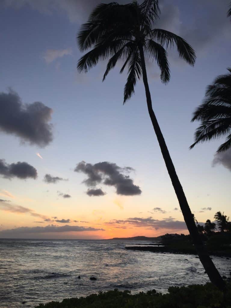
El Capitan is actually the terminating peak in this range, and should you ever be driving past Guadalupe Mountains National Park on Highway 62, it will be the impressive, sheer faced monolith that looms over you. Though it does not own the title of tallest mountain in Texas, it still served as a guiding landmark to earlier settlers, as well as the Butterfield Overland stagecoach line. You can actually still witness the stagecoach station ruins on the Pinery Nature Trail within the park! El Capitan is absolutely breathtaking to view at sunset, so if you can time a drive-by for then, it will not disappoint!
What to Know Before You Go
Here’s a few important tips to know before you head out on the Guadalupe Peak Trail!
- Guadalupe Mountains National Park Entrance Fees: $10 per person (you can pay in person via credit card at the Pine Springs Visitor Center which is adjacent to the trailhead, but keep in mind it does not open until 8 AM. Or you can bring cash and pay at any trailhead box in the park, which might be better for early morning starts on the Guadalupe Peak Trail).
- Hours: open daily year round
- Permits: permits are NOT required to hike the Guadalupe Peak Trail, unless you are planning to camp overnight below the summit in the backcountry site on the trail.
- Best Time of Year to Hike the Guadalupe Peak Trail: spring and fall
- Worst Time of Year to Hike the Guadalupe Peak Trail: summer
- Weather: Guadalupe Peak can have extreme ranges in weather and temperatures, from warmer near the base of the peak in the Chihuahuan Desert, to colder near the summit. Guadalupe Peak also sees considerable wind gusts much of the year. Always check mountain-forecast.com before your hike to check the mountain specific weather.
- Timezones: Guadalupe Mountains National Park resides in the small portion of west Texas that actually straddles the Central and Mountain timezones. Certain portions of the park are in different timezones.

- Camping: there are 2 developed campgrounds in the park. I would highly recommend camping at the Pine Springs Campground which is immediately adjacent to the Guadalupe Peak Trailhead. Reservations can be made online. There is also the backcountry Guadalupe Peak primitive campsite located just below the summit, which requires a backcountry permit.
- Pet Policy: pets are NOT allowed on the Guadalupe Peak Trail
- Necessary Training: Guadalupe Peak is a Class 1 Trail. It is well maintained and easy to follow. There are NO technical skills required, and there is no bouldering or scrambling involved. It is rated as strenuous, due to its 8+ miles and 3,000 + feet of elevation gain. There is a decent amount of sun and wind exposure, with some portions of shade. The first several miles can be the toughest for many people, as there are a series of uphill switchbacks. It is recommended to get a few 8 ish mile hikes of similar elevation gain under your belt before attempting the Guadalupe Peak hike. Several months of weekly 5+ training hikes would be beneficial in addition to several 8 mile practice hikes.
- Estimated Time to Complete the Guadalupe Peak Hike: on average 6 – 8 hours
- Recommended Gear Quick Links:
- Columbia Hiking Pants
- HOKA One One Speedgoat Trail Running Shoes
- Hilly Twin Skin Socks
- Camelbak Helena 20 Daypack
- Platypus 3 Liter Hydration Bladder
- Outdoor Research Helium Waterproof and Windproof Ultralightweight Jacket
- Black Diamond Trekking Poles (optional)
- Squeezable Peanut Butter Packets
- Tuna Packets
- RX Bars
- GU Energy Gels
*This is not an exhaustive list, but it covers all the basics you will need to hike the tallest mountain in Texas!
*Get a complete list of recommended day hiking snacks HERE, and a full checklist of day hiking essentials HERE!
***Download your own day hiking essentials checklist HERE!
Now to the fun stuff, preparing to conquer the Guadalupe Peak hike and the highest point in Texas! If you are looking for a challenging, beginner friendly, high elevation peak, then this is the one! This hike will take it out of you physically, but it is doable without any technical skills or specialized equipment.
A few quick notes about additional recommended gear:
***Should you bring hiking poles for Guadalupe Peak? For me, this hike is right on the bubble – if you typically hike with hiking poles for other 8ish mile, strenuous uphill hikes, then bring them for Guadalupe as well. If you know that you haven’t found them necessary for other well maintained trails of similar nature, than Guadalupe won’t be a hike that will throw you any curve balls requiring hiking poles. There is a substantial amount of uphill and elevation gain, but the trail is well maintained. For recommendations on hiking poles, you absolutely can’t go wrong with the most trusted name out there, Black Diamond hiking poles. I love this particular model because they are sturdy yet lightweight, adjustable, and the cork handles absorb sweat rather than creating the slippery mess that other plasticy and rubbery handles of other models can create.
Water and snacks may seem like obvious things to bring, but as for a few other things… sunscreen is necessary because half of the hike is in broad sunlight, and half of it is in the shade. Therefore, sunscreen will be useful for the sunny half!
The other two items I am always extremely grateful for are my HOKA One One Speedgoat trail runners and the best blister proof hiking socks I’ve ever known!
Blisters are the quickest way to end a hike, and I have been extremely blister prone in the past, especially on long hikes or runs. I have had ZERO issues with blisters since discovering Hilly Twin Skin socks. Not even on all day hikes like the Grand Canyon’s Rim to Rim hike. These amazing hiking and running socks are lined, which helps prevent the friction that can cause blisters! I top off my hiking ensemble finally with a pair of Columbia water resistant hiking pants as well. I only have positive things to say regarding my Columbia hiking pants – perfect fit with the drawstring waist and boot cut leg, and lightweight and breathable, yet durable.
The HOKA trail runners are fantastic to hike in, and I am grateful to have them as this is a very gravely, loose, and rocky path. The grip on these shoes are amazing, and I never once have felt unstable in them. You can step on loose rock shards and these shoes are guaranteed to have a solid grip on this type of surface. Even on minor slips, these shoes stop me from completely sliding. There have been many times I’ve stepped down directly on the pointed edge of a rock, and never felt a thing through the soles.
***Don’t Forget! You can download your own day hiking essentials checklist HERE!
Quick Facts on the Guadalupe Peak Hike
Length: 8.4 miles out and back roundtrip
Rating: Difficult – this is a non-technical, Class 1 climb, but there is substantial elevation gain.
Elevation: 8,750 feet
Elevation Gain: 2,952 feet

Facilities/Parking: there is plenty of parking at the trailhead, as well as restrooms and a water refill station
When Is the Best Time to Hike the Guadalupe Peak Trail? Shoulder seasons of Fall and Spring are the best time of year, as winter can see snow and ice and some strong winds, and summer can become unbearably hot and with temperatures not safe to hike in (and there is no reliable water sources on Guadalupe Peak). I have done both spring, fall, and winter visits, with my latest winter ascent being in December. On that particular trip, I just barely beat out a big winter storm. Spring is cold and windy, but doable with the right layers. I have made it work in March and May, though by May it warms up considerably during the day, and you will need plenty of water! Fall has perhaps been my most pleasant season to visit in, though it can be cold in the early morning, so plan accordingly. If you visit in fall, be sure to set aside some extra time to visit the splendid fall foliage on display in McKittrick Canyon!
Guadalupe Peak Trail Report with Pictures
On to the Guadalupe Peak Trail, a hike that encompasses 8.4 miles of ascent through varied terrain, taking most hikers an average of 6-8 hours roundtrip to complete. All the times I have hiked the Guadalupe Peak Trail, I have done so in under 7 hours, stopping for a snack once or twice, and spending only 5 or so minutes at the summit.
Guadalupe Peak Trail Route – from Pine Springs Trailhead / Guadalupe Peak Trailhead to the summit!
*NOTE: Google Maps refers to the Guadalupe Peak Trailhead as the Pine Springs Trailhead.
Driving in from Highway 62 enroute to Guadalupe Mountains National Park, the most impressive sight is actually El Capitan, the monolith of a peak with the sheer cliff face that is the southernmost terminating peak on the Guadalupe Mountains range. And as I said before, absolutely stunning at sunset! But more importantly, you will be able to tell just by that drive-by that this is a park a little more off-the-beaten-path, with no major cities or other tourist attractions in the immediate area. No long lines of cars, no long lines of tourists, an hour from Carlsbad and just over an hour from El Paso. It is truly a wandering through the middle of the high desert experience!
Mileage Breakdown and Pictures:
Pine Springs Trailhead (trailhead for the Guadalupe Peak Trail): Mile 0
When arriving, my first stop is always at the Pine Springs Visitor Center. The Visitor Center opens at 8am, but the but the bathrooms outside the Visitor Center will be open earlier. There are also facilities located at the trailhead for Guadalupe Peak, including restrooms and a water bottle filling station. Don’t forget to bring along your $10 of cash or credit card for your park entrance fee. You can pay your fee at the Pine Springs Visitor Center, or at the self pay stations located at any of the park trailheads, including the trailhead for the Guadalupe Peak hike.
During my 1st trip up Guadalupe Peak, I met Julie outside the Pine Springs Visitor Center. She introduced herself, we traded information and where we were from and our excitement about the hike. Julie was there with three other friends, and assured me that as I was solo hiking for the first time that day, her and her group would be right behind me should I need anything on the trail. She then told me that she was proud of me for attempting this hike alone. That small gesture of encouragement made my day and was one of the highlights of that trip.
Julie was a wonderful preview of the type of camaraderie and community I found that day on the trail, everyone sharing words of encouragement and pushing each other onward! It has become one of the defining characteristics of hikers that I have discovered as I have added to my inventory of hikes. I wish I had a way to get in touch with Julie and thank her for the encouragement that day.
Continuing on from the Visitor Center, the best place to access the Guadalupe Peak trailhead is from the Pine Springs Campground parking lot, about a one minute drive further in from the Pine Springs Visitor Center, and also where the Pine Springs Campground is located, should you choose to stay there during your time at Guadalupe. You can get more info on camping at Guadalupe Mountains National Park on the park website.

The trailhead for Guadalupe Peak actually starts at the Pine Springs Trailhead, which is the trailhead for multiple trails that almost immediately branch off, including the Guadalupe Peak hike. Hiking in from the Pine Springs Campground, the Pine Springs Trailhead almost immediately branches off on the right side for the Tejas and Frijole Trails. Continue straight. The second split is the one you are going to want. The trail will split 3 ways. The Devil’s Hall Trail is on the right, and El Capitan Trail is on the left. Continue straight for the Guadalupe Peak Trail. There is plenty of signage and the trails are well labeled, so it should not be difficult to make your way on the start of the Guadalupe Peak Trail.
The first couple of miles up the east face of the tallest mountain in Texas is mostly desert shrubbery and sparse vegetation, with direct sunlight and fantastic views looking up towards the Guadalupe Mountains range.


The first time I hiked Guadalupe Peak, I was warned ahead of time that the first mile and a half is the most strenuous part of this hike with its switchbacks, and I would continue to agree with that! However, I would rather have the first part of the hike be the toughest part, rather than the end of the hike when my legs are starting to turn to jello! Enjoy the challenging switchbacks up the initial portion of the Guadalupe Peak Trail, and know that once you round the face of the mountain, you’ll get some relief from the switchbacks.


Rounding the Face of the Mountain: Mile 1.5
As you get close to rounding the face of the east side of the mountain to turn onto the north side, you will encounter a sheer cliff side that is the narrowest part of the hike, and the one part of the hike that would give anyone who might be height-challenged a few moments of nervousness. But again, the views in these spots are breathtaking in their drop-offs! You’ll know you are getting close when you see the signs warning equestrians to dismount.


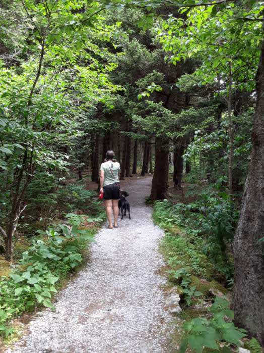
At this point in the hike, you may wonder when you are going to see these supposed ponderosa forests, because up until then, it is pretty barren. As soon as you round onto the north face of the mountain, you will notice 3 things: a sudden increase in the strength of the wind gusts, the leveling out of the trail, and the ponderosa forest! This side of the mountain gets less direct sunlight, which I guess the ponderosas seem to be more akin to.
Although the temperature tends to drop substantially for this part of the hike due to the high winds, it is probably my favorite part of the ascent. There are parts completely enclosed in pine forest tunnels, with the occasional old, weathered, and bare pine jutting out from the treeline and pointing upwards towards a stark, blue sky.

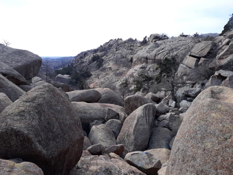
At this stretch of the hike, it truly can feel like being alone on the tallest mountain in Texas, as you may not pass any other hikers for possibly an hour or more. Several miles up, the treeline starts to thin just a little, and the terrain becomes a little more rocky and bare.

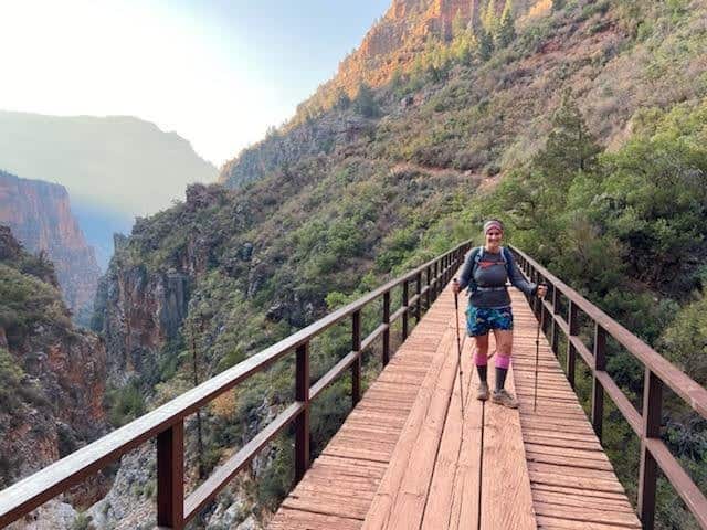
Backcountry Primitive Campsite / False Summit / Wooden Bridge: ~ Mile 3
As you near the summit of the highest point in Texas, you will pass the small hike-in, primitive campground site, and continue to see the forest thinning out. If you are keeping a good pace, you probably have less than an hour to the summit after passing the backcountry campground spot. This area here is often referred to as a “false summit” in its appearance, but know that you are closing in on the prize! Hikers will then approach a wooden bridge that crosses a chasm in a cliff side, and on the other side of the bridge is a huge fallen ponderosa that the light hits in just the right way to make a perfect pit stop for refueling and warming up! The trail will start to pick up in incline after the bridge as you make your final approach towards the summit!

It is possible to camp overnight at the primitive backcountry site. Just make sure to get the proper Wilderness Use Permit from the Visitor Center prior. A Wilderness Use Permit is required for all backcountry camping, including an overnight stay at the primitive site on Guadalupe Peak. It is a great option for those that wish to witness a stunning sunset or sunrise along with their Guadalupe Peak summit!
The last mile or so emerges completely from the forest and becomes open mountain face with a few switchbacks, and for the first time since rounding the initial turn from the east side of the mountain, you get a true view of the elevation gain and the towering, unobstructed views west towards the Salt Flats, the adventure filled west Texas destination of El Paso, the top of neighboring El Capitan, and east towards Carlsbad, New Mexico.


It is also a huge morale boost to be able to see the summit from here! Continue to follow the switchbacks up, and in case you forget where you are, on one of the last switchbacks you will see this guy pointing you in the right direction!

Now for the last 10 minutes or so of meandering along rocky trails towards the top!


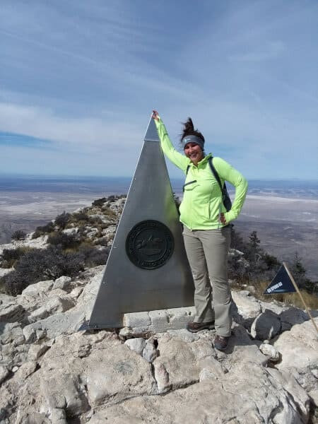
The Summit of the Guadalupe Peak Trail: Mile 4.2
And then you are there, at the summit of the tallest mountain in Texas!

It is quite a moment to realize that you can turn a full 360 degrees with no obstructions, because there is literally nothing taller than you at that moment! My first summit of Guadalupe Peak was the first time in my life I could look around me and have that realization! Take in the surrounding views of the best of Guadalupe Mountains National Park, the Salt Flats to the west, and New Mexico to the north! It is stunning to the point of startling to realize that there is very little sign of humanity’s mark from this vantage point, and that amount of isolation is overwhelmingly peaceful!
During my first trip up Guadalupe Peak, when I arrived at the top I was greeted by a group of Alabama college students doing their best to recline in the nooks and crags of the sheer rock face summit, but this hasn’t always been the case. Sometimes the summit is almost nearly empty! I never spend more than about 5 minutes at the top, due to the strong wind gusts and cold temperatures, but always long enough to take a picture and take in the views. I prefer to take my lunch break a short ways below the summit on my descent, in the relief of some wind break. I am always surprised to find out who else is on the summit of Guadalupe Peak, as this mountain seems to draw hikers from all over the country to this little nook of Texas!
Before you head back down the way you came, be sure to sign the register at the summit!

A little background on that summit pyramid monument and what it represents – this pyramid was erected in 1958 by American Airlines to commemorate the one hundred year anniversary of the Butterfield Overland Stagecoach route. One side has the American Airlines logo, one side has a U.S. Postal Service tribute, and the final side has the Boy Scouts of America logo.
Descending the Guadalupe Peak Trail: Miles 4.2 – 8.4
The sense of community tends to increase dramatically on the way down! First of all, there are usually more hikers later in the day, and second, everyone who sees you making the descent wants to know what the top is like! So inevitably you exchange a lot of mutual encouragements to fellow hikers, as well as give them your approximate timeframe to the top! On my first trip, I spotted Julie again on my descent, hiking solo at this point, and she again told me she was proud of me for accomplishing the ascent! I like to stop at my sunny spot on the fallen ponderosa for a lunch break, before crossing back over the bridge and pushing on down the mountain.
As it transitions from morning to afternoon, you may notice many more hikers on the path at this point. I cannot say this is typical for an average week day since I have only been there on holiday breaks or weekends, but based on my experience, start out early if you want to feel like you have the mountain to yourself. On average, 6 – 8 hours after starting out, you will be back at the bottom and emerging into the parking lot.

Why You Should Take on the Guadalupe Peak Hike
This hike definitely takes it out of me, but I did not go wrong in picking out a great beginner peak that first time, or continuing to return to the fun that is hiking Guadalupe Peak! In a stunner of a National Park for that matter! If you want to challenge yourself, if you want that sense of peaceful isolation, if you want breathtaking views, if you want to prove that Texas is not all flat, if you want a hike that will take you through multiple personalities of landscapes and environments, and if you want to experience that feeling of being taller than anything else in Texas as you stand atop the highest point in Texas, give the Guadalupe Peak hike a shot, you will not be disappointed! This hike gave me the confidence to continue pursuing more hiking goals, including more solo hikes, more 50 state highpointing hikes, and more high elevation hikes!

Read More: wanna know what some of my other favorite Texas hikes are besides the highest point in Texas? Then check out:
- Lighthouse Trail in Palo Duro Canyon State Park!
- McKittrick Canyon Trail in Guadalupe Mountains National Park
- The Best El Paso Hiking Trails
- The Top 5 Canyons in Texas
- Exploring Santa Elena Canyon by Land and Water
- The Lost Mine Trail and The Window Trail in Big Bend National Park
- Hiking in Caprock Canyon State Park
- The Monahans Sand Dunes
- The Top 13 Hiking Trails Near Fort Worth
****The highest point in Texas was my first state high point hike, but it was far from my last! If highpointing interests you in particular, be sure to read my guides to other southwestern state highpoint hikes, including Arizona’s gorgeous Humphrey’s Peak, Utah’s remote Kings Peak, California’s towering Mt Whitney, and New Mexico’s exciting Wheeler Peak!
****Planning your next epic hike? Take advantage of my guide to what NOT to do when hiking, and the five crucial mistakes to avoid for a successful hike!
What About the Other 49 U.S. State High Points?
***Is Hiking Training on your horizon? If you are chasing challenging hikes like the highest point in Texas, you may find it beneficial to invest in the right training and tracking tools! One of the most important steps in training for any big physical and active goal is getting organized, and having a plan to stay motivated and on task to achieve your goal! Make sure to check out my collection of fitness trackers, checklists, and organizers to help you achieve that next step in your active travel pursuits!
RELATED ARTICLES:
- One Day in Guadalupe Mountains National Park
- How to Day Hike the McKittrick Canyon Trail in Guadalupe Mountains National Park
- The 5 Best National Parks in the Southwest
- The 8 Best Hikes in Guadalupe Mountains National Park
PIN for LATER!


Beautifully written. Sounds like an exciting hike.
Thank you! It was a very exciting day!
A trip during the summer earns you an unforgettable experience of being swarmed by ladybugs as well! Well worth the trip!
I wish I had seen all these ladybugs! I wonder what draws them all to this area at that time?
Wow what an incredible hike!! The view at the top looks well worth the gruelling climb. I know the wind can make it extra challenging. I cannot wait to hike in the US sometime hopefully soon. Hiking holidays are ‘our thing’ but want to wait until we can really cover a lot of the States in one trip. I’ll add this region to our bucket list. Great photos!
I will be honest, I had never heard of the Guadalupe Peak before. I am sure it must have been a great high to reach the highest point in Texas (8,749 feet) 🙂 Looks like the scattered conifer forests must have provided some relief, hiking up this trail. All the best for your 14’er 🙂
What stunning views! I’d love to visit Texas someday- and do this hike.
Sorry to ask but what if you need to use the bathroom while hiking? Just go behind a bush I guess lol?
Thanks
Haha, on Guadalupe Peak the answer is yes! I made it work 😉 Some long trails will have potty “shacks”, this one does not! Just make sure to bring toiletries with you in case, and pack out.
Great post. My 11 yr old son and I plan to tackle this on Columbus Day weekend. What cities would you recommend us stopping to eat at on the way to/from? We’ll be coming from San Antonio.
In the immortal words of Dora the Explorer, “Lo hicimos! We did it!” Took us 3.5 hrs to get to the top and my son needed every single one of those fellow hikers’ encouragement to make it to the top. What an amazing view. Thank you for this motivational blog!
That’s awesome! And yes fellow hikers and their encouragement can be such a boost, I’m glad you got to experience that! 3.5 hours to the top is amazing!
What time of the year did you do this hike? I’m curious since you mention it being so cold. If it’s always like that or only in the non-summer months?
Hi Julie, I hiked Guadalupe Peak in mid-March. The temperatures around the base are mildly cold that time of year, but it gets very cold and windy the higher up the mountain you go. When you round the face of the mountain, you’ll be in forest and shade, which adds to the cold. By the time you reach the summit, it will likely be very cold and windy and you will benefit from having good layers!