Outdoor Activities in El Paso: The Best Hiking, Climbing, Biking, and Camping
Most people would probably not think of El Paso as a booming tourist destination per say, but I am making the case for just how ruggedly beautiful this corner of Texas truly is. For the nature enthusiast or active traveler, the outdoor activities in El Paso are plentiful. It is a mountainous playground, full of the best hikes in El Paso, adventurous rock climbing, demanding mountain biking, and secluded camping near El Paso.

Disclosure: Below are some affiliate links-these are all products I highly recommend. I won’t make any recommendations on this page that I haven’t tested or personally used!
Keep reading to discover all of the best outdoor activities in El Paso:
- Hiking in El Paso
- Camping in El Paso
- Rock Climbing in El Paso
- Mountain Biking in El Paso
Table of Contents
Hiking in El Paso
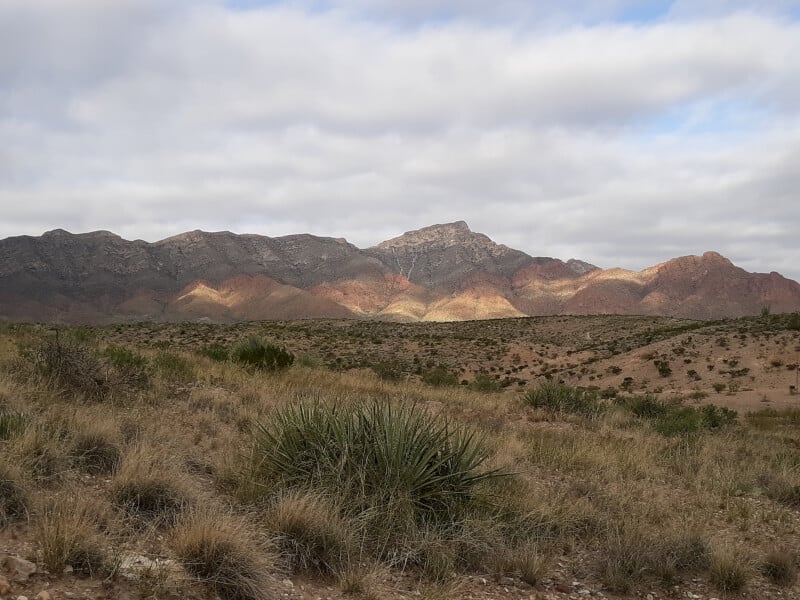
Due to its resident mountain range and subsequently rugged terrain, El Paso offers a surprising amount of truly challenging hikes, ranging in length from short, mile long jaunts, to all day treks. With over 80 plus trails throughout the region, the possibilities are endless: case in point are some of these best hikes in El Paso that I discovered:
Easy Day Hiking in El Paso
Aztec Caves Trail
This hike, though short, is somewhat steep, and terminates in a grouping of caves that can be explored with flashlights. It is a very convenient, easily accessible hike that is located within the Franklin Mountains State Park, specifically in the parking lot for the Aztec Caves campsites.
Length: 1.2 mile out and back roundtrip
Elevation Gain: 419 feet

Rating: Easy

Tom Mays Nature Walk
Also located within the Franklin Mountains State Park boundaries, this trail is just within the park gates, on the left hand side as you drive in along the main park road. It is a short, flat, easy hike, that allows you to become more acquainted with the terrain, vegetation, and views at the base of the Franklin Mountains.
Length: 0.8 mile loop roundtrip
Elevation Gain: 68 feet

Rating: Easy
Insider Tip: I am a big proponent of the AllTrails app. I was able to find all of my trailheads here in El Paso accurately using this app, and would recommend the same to any of my fellow hikers, whether you choose to utilize the free or paid version.
Difficult Day Hiking in El Paso
El Paso Tin Mines Trail
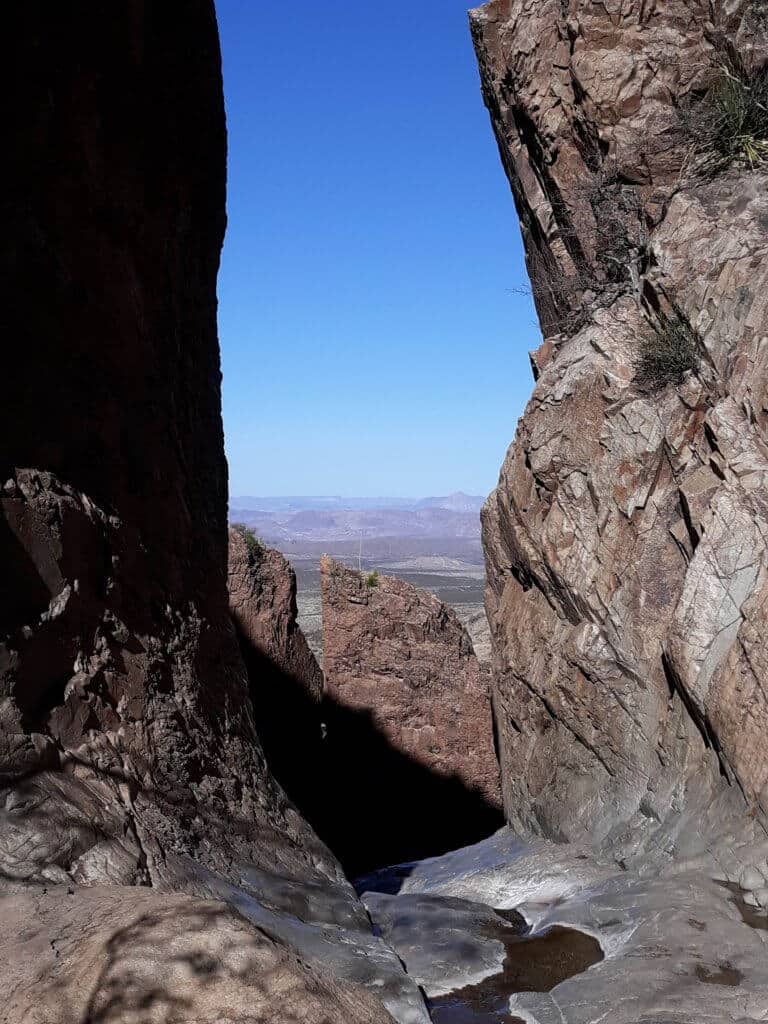
This is my favorite hiking in El Paso, not only for the desert views that I find beautiful, but also because of what waits for hikers at the end of the trail. As you might guess from the name, this trail ends at an abandoned tin mine. The fascinating part though, is that these tin mines were the only ones to ever exist in the United States, which means this is literally a “one of a kind” hike, and one of the reasons it is among the best hikes in El Paso.
The added bonus is that you can actually explore inside these tin mines. If you are a Lord of the Rings fan like me, you will understand the giddiness of walking underground through “the mines”. Visitors can still observe the rough-hewn, chisel marked walls inside the cave, shimmering with specks of subterranean minerals.
Depending on who you ask, some would describe this hike as either easy or moderate. I lean more towards moderate, due to the 1,000 feet increase in elevation experienced primarily during the second half of this hike.
Also, the trail is marked well right up until the end. The final hill that has to be climbed off to the left of the main trail is not very well marked, but you should be able to visibly see the old brick and metal grating of the mine to the left of the main trail to lead you these last few steps.


Length: 6.6 miles out and back roundtrip
Elevation Gain: 1,023 feet

Rating: Moderate
Insider Tip: While this trail is part of the Franklin Mountains, the trail head is actually located outside the state park boundaries, in a residential area of El Paso. You will locate the trail head in the Chuck Heinrich Park, by climbing up the white dam and heading left.
B-36 Plane Wreck Trail
The initial mile or so of this hike is on the marked path of the Thousand Steps Trail (keep reading for more info on the Thousand Steps Trail next!). The trailhead for the B-36 Wreck Trail is the same as the Thousand Steps Trail/Ranger Peak Trail, and there will be an information sign at the trailhead denoting this. There is an overlook of the plane wreckage on the Thousand Steps Trail, but to actually reach the plane wreckage up close requires going off trail, hopping boulders up a mountainside.

After the first mile, start looking for the unmarked informal trail on the left that branches off from the main trail. The best way I can describe how to find this trail to the wreckage is to watch for the giant triangle boulder around mile one of the Thousand Steps trail. Once you see this boulder, the trail to the B-36 wreckage will be several feet ahead on the left.

Someone also helpfully left a string of cairns marking the way up the mountainside, so you can also rely on these to guide you. This ascent can be rough going at times, and involves hoisting and jumping from boulder to boulder. It takes approximately thirty minutes to reach the wreckage, so be sure that you are up for this type of climb before starting.
The climb itself may be more memorable than the actual destination. It is a fun way to add some varied terrain into your west Texas hiking. The actual B-36 wreckage consists of several large, rusted axles, and a green tinted axle and box device. Several other smaller plates are also scattered among the mountainside, but that is really all there is to see. It is interesting and another “one of a kind” type of hiking in El Paso, plus the views over the city and the surrounding Chihuahuan Desert are breathtaking! If you are looking for more from this hike, you can rejoin the main Thousand Steps Trail, and continue on to Ranger Peak.

Length: 2.3 miles out and back roundtrip
Elevation Gain: 1,069 feet

Rating: Easy on marked trail (Thousand Steps Trail – see below), difficult on ascent up to crash site
Insider Tip: This is another trail that, while located in the Franklin Mountains, the trailhead is actually located outside the state park boundaries in a residential neighborhood in El Paso. You can locate the small parking lot and trailhead at the very end of N. Stanton Street in El Paso.
Thousand Steps Trail
This trail is the same trailhead for accessing the B-36 wreckage, but continues on to Ranger Peak and the Wyler Aerial Tramway, if hiked through to completion. Initially there is a quick, steep climb from the parking lot to the trail under the water tower, but the first mile or so after is relatively easy with a gentle uphill grade. The last several miles do become progressively steeper the closer to the peak one gets, but the views are the payoff to the effort here!

Length: 3.7 mile loop roundtrip
Elevation Gain: 1,423 feet

Rating: Hard ( ~ 1,500 feet in elevation gain )
Mundy’s Gap Overlook Trail
The Mundy’s Gap Trail is true to its name. It traverses a “gap” between the Franklin Mountains range. Hikers on the El Paso Tin Mines trail will pass one of the branches of Mundy’s Gap, but its trailhead starts just inside the Franklin Mountains State Park borders, along the main Tom Mays Park Access Road.

Length: 3.9 miles out and back roundtrip
Elevation Gain: 1,003 feet

Rating: Hard ( ~ 1,000 feet elevation gain )
Schaeffer Shuffle Trail
This trailhead is within the Franklin Mountains State Park borders at the very end of the main park road, just right of the Sunset Pavilion. There are several sections of steep uphill and loose, rocky terrain, followed by steep downhills that require extra precaution. But overall, the panoramic views of the surrounding rugged desert, weaving through the mountainsides, is a fun and varied way to hike. When I completed the Franklin Mountains trail run that is held here annually every November, this is the trail that us runners started out on, and it is a superb trail for trail running, because of all the varied terrain and ups and downs.
Length: 2.6 mile loop roundtrip
Elevation Gain: 698 feet

Rating: Moderate
North Mount Franklin Trail
If you want to take on the highest trail in this region, then you will want to check out North Mount Franklin, the highest peak in the Franklin range. The trailhead is in the same nearby vicinity as the trailhead for Mundy’s Gap, just within the Franklin Mountain State Park borders.

Length: 7.2 miles out and back roundtrip
Elevation Gain: 2,408 feet

Rating: Hard ( ~ 2,500 feet elevation gain )
Insider Tip: If you are looking for a way to encompass several of these amazing trails, all in one grueling yet satisfying day, I would suggest participating in a trail run. My suggestion for an epic trail run that will give you a chance to experience the best of El Paso’s trails is the Franklin Mountains Trail Run, organized by Trail Racing Over Texas! Head on over to check out the distances they offer, as well as some of their other Texas races! Then put it on your calendar! Trust me, I ran the Franklin Mountains Trail Run, and I can’t wait to do it again!
Rock Climbing in El Paso
El Paso is special among Texas in that some of the most premier climbing opportunities reside here, particularly in Hueco Tanks State Park. The history of this state park’s “huecos’ go back thousands of years, when early residents of the area used to obtain pooled water from these natural rocky basins. Now, visitors come here for one unique experience, the chance to tackle some of Texas’s, if not the country’s, most challenging rock climbs.
Rock climbing is available on self guided and guided tours, although it is important to keep in mind that some areas of the park are only accessible on a guided tour. North Mountain is renowned for having the best rock climbing in the park, but a reservation is required. East and West Mountains are also exceptional, but require guides. In summary, the best plan is to make arrangements well in advance by contacting the state park.
Whether you are planning to visit Hueco Tanks as an expert climber, or a beginner, you will find a plethora of rock climbing challenges to fit your level. It is important to bring your own climbing equipment, including climbing shoes. Other recommended items for your climbing packing list include chalk, crash pad, sunscreen, and plenty of water.
Entrance fees into Hueco Tanks State Park are $7 a person.
Insider Tip: Access to Hueco Tanks State Park is limited. Permits are issued for up to 70 people daily into Hueco Tanks State Park’s self guided areas. Guided tours are also available. Reference the website here to ensure proper attainment of permit.
Bonus: As you traverse the boulders of Hueco Tanks, you will also have the chance to witness rock art left behind by early inhabitants.
Mountain Biking in El Paso
As mentioned before, there are over 80 plus trails weaving and winding throughout El Paso, which means not only can you leave behind a multitude of footprints here, but if you so choose, it is also the perfect destination to leave behind some tread marks!

Franklin Mountains State Park contains some of the best mountain biking trails in the area. The El Paso Tin Mines Trail is not only popular among hikers, but bikers as well. There is the option to bike the 6.6 mile roundtrip trail, or add on some of the “split off” trails, such as the Lazy Cow, Pole Cat Alley, or Mundy’s Gap. For longer distances, the Franklin Mountain Loop is a grueling 25 mile biking experience. For detailed information on all of El Paso’s mountain biking trails, read more here.
Insider Tip: Hikers and bikers mingle simultaneously on many of El Paso’s most cherished trails, so take extra precaution for sharing the trails!
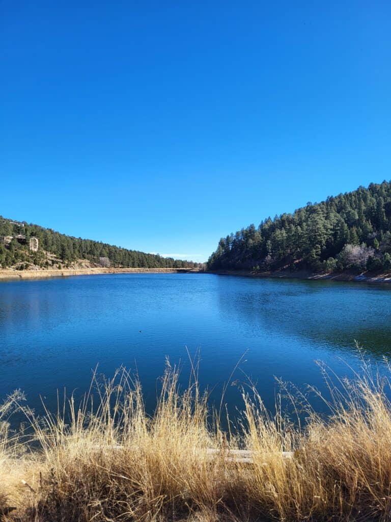
Camping Near El Paso
Hueco Tanks State Park Camping
Hueco Tanks State Park is a great option for those looking for secluded camping near El Paso! The majority of visitors here come for day use purposes, but there are 20 campsites available that are reservable via phone. There are 16 sites with water and electric for $16 nightly, and 4 sites that are water only at $12 nightly.
Insider Tip: There is no late check in for campsites at Hueco Tanks State Park. Campers must check in at least an hour before closing. There is also a permanent campfire ban in place, and pets are only allowed in the campground, not on trails or mountains.
Franklin Mountains State Park Camping
This is my personal favorite when it comes to camping near El Paso. While there are some campsites here that are in close proximity to the road and parking lots, there are many that are much more secluded. When calling to reserve a campsite, request a campsite that is further back from the road, as there are several sites nestled in the shadows of the mountains.
Most of the campsites are liberally spread apart, and lend a sense of seclusion. Surrounded on three sides by mountain range views of the Franklins, and one side spilling out over El Paso in the distance, the views here are spectacular, especially as the sun peaks above the mountains in the morning and at dusk. A solid choice for camping near El Paso!


All campsites are reservable online, starting at $10 nightly. All sites have a grill, and most have a shade pavilion, although there are several that do not. Reserve your campsite online here.
Restrooms are available in several locations within the state park, however, there is no running water or showers, and toilets are composting. Come prepared with a personal supply of water.
Insider Tip: the main gate into Franklin Mountains State Park closes at 5pm. In order to access the park after hours, call ahead to request the gate code. Markers on campsites can be very small and difficult to read from the road, so if arriving after sundown, call ahead to request the site number to make locating easier.
Why You Need to Visit the best outdoor activities in El paso
No matter where I go in Texas, I continue to be surprised at what is in store around every corner. The outdoor activities in El Paso are no different, with a highly under-rated wealth of active travel opportunities, some of which are hard to find anywhere else in the state, or the country for that matter! So the next time you are looking for a rewarding hiking, climbing, biking, or camping experience, keep El Paso in mind!
Locations of the best outdoor activities in El Paso
Read More: about a few of my other favorite Texas moments, like hiking to the top of Texas, trekking the 2nd largest canyon in the United States, or channeling my inner child while sand dune sledding in Monahans!
RELATED ARTICLES:
- Mountains in Texas: Fact or Fiction?
- The Absolute BEST Hikes in Texas You Can’t Afford to Miss
- The TOP 5 Canyons in Texas You Have to See in Person
- The BEST Outdoor Things to Do in West Texas
- Top Things to Do in Guadalupe Mountains National Park
PIN for LATER!


Wow the 1000 stephs rail is right up my alley. Beautiful! I would live to hike there as well as there is just nobody around. Amazing scenery throughout.
Corina, yes it’s beautiful desert scenery! And so many great hikes, no matter what level you are looking for!
I love this article! I am from El Paso and I always find myself explaining to people 1. Where it is 2. Just how much there is to do!
The mountains are quite possibly my favorite feature of the city, besides the good Mexican food of course!
If you ever go back you should check out some of the OHV trails. It’s tons of fun!
Thanks for highlighting and sharing my city! ?
Justine, love your suggestions! And I also love highlighting some of the lesser known but amazing places here in my home state!
Hey, thanks for sharing the adventure activities. I really like to go for the outdoor activities. I am travelling to El paso next month. I love to do outdoor activities it helps to energy and it gives positivity.