The 17 Best Hikes in Texas You Can’t Afford to Miss
Texas has so much to offer in terms of trails, and one of the best ways to experience the Lone Star State is to tackle this list of the best hikes in Texas! These 17 best hiking trails in Texas include canyons, summits, deserts, waterfalls, high points, unique rock formations, even an abandoned tin mine! Get ready to explore this list of the best trails in Texas and the best places to hike in Texas!
- The Lighthouse Trail – Palo Duro Canyon State Park
- Devils Hall Trail – Guadalupe Mountains National Park
- Santa Elena Canyon – Big Bend National Park
- Enchanted Rock – Enchanted Rock State Natural Area
- Guadalupe Peak – Guadalupe Mountains National Park
- The Window Trail – Big Bend National Park
- Haynes Ridge Trail – Caprock Canyons State Park
- Lost Mine Trail – Big Bend National Park
- Penitentiary Hollow – Lake Mineral Wells State Park
- McKittrick Canyon – Guadalupe Mountains National Park
- Emory Peak – Big Bend National Park
- Rio Grande Trail – Seminole Canyon State Park
- Lost Maples East Trail – Lost Maples State Natural Area
- Eagle Point Trail – Caprock Canyons State Park
- Ol Baldy – Garner State Park
- El Paso Tin Mines – Franklin Mountains State Park
- Gorman Falls – Colorado Bend State Park

Disclosure: Below are some affiliate links-these are all products I highly recommend. I won’t make any recommendations on this page that I haven’t tested or personally used! Enjoy this guide to the best hikes in Texas!
Table of Contents
The 17 Best Hikes in Texas
This list of the best places to hike in Texas spans the whole state, and includes a wealth of trails in state parks and both National Parks in Texas!
Map of the 17 Best Hikes in Texas
Locations of the 17 best hiking trails in Texas!
#1: Lighthouse Trail – Palo Duro Canyon State Park
- Trailhead Location
- Length: 5.8 miles out and back roundtrip
- Rating: Moderate – with an elevation gain of just over 500 feet, this is a relatively consistent grade, with a few brief spots of increased incline, mostly near the end as you climb the formation. The elements also add to the rating of this hike, as there is almost minimal shade, so extra caution needs to be taken in the warmer months. Always hike with plenty of water!
- Estimated Time to Complete: 2 – 3 hours
- Fees: $8 entrance fee
This trail highlights not only the surprisingly striking red rock sculptures that can be found in west Texas, but also the iconic landmark that is the best part of this hike! It is easy to see why Palo Duro Canyon is called the “Grand Canyon of Texas”!
The majority of the hike in towards “the Lighthouse” is relatively flat with wide open expanses of the surrounding canyon. Most of the elevation gain comes when you climb to the plateau at the base of the Lighthouse.
***Learn more about the Lighthouse Trail in Palo Duro Canyon State Park here

#2: Devil’s Hall Trail – Guadalupe Mountains National Park
- Trailhead Location
- Length: 3.6 miles out and back roundtrip
- Rating: Moderate to Hard – this hike is short, but climbs over 500 feet in elevation gain, and includes some non technical boulder hopping and scrambling.
- Estimated Time to Complete: 1.5 – 2.5 hours
- Fees: $10 per person
If you like hiking slot canyons, in a under-rated and remote National Park, then this hiking trail is for you! Lose yourself amid the towering canyon walls, and prepare to climb the natural stairways through Devil’s Hall! There is some boulder scrambling and hopping, but it is non technical, and just another part of what makes this trail one of the best hikes in Texas and one of the best hikes in Guadalupe Mountains National Park!

#3: Santa Elena Canyon Trail – Big Bend National Park
- Trailhead Location
- Length: 1.4 miles out and back roundtrip
- Rating: Easy – this trail is just under 200 feet in elevation gain, but it is even less if you choose to stop at the shoreline. If you opt to climb the canyon wall, it is a brief incline.
- Estimated Time to Complete: 30 – 45 minutes
- Fees: $30 per vehicle
This trail lands a spot on the best hikes in Texas because it offers one of the most spectacular views of the mighty Rio Grande River, from one of the most recognizable canyons in Texas! What’s additionally fun about the Santa Elena Canyon Trail is that you can follow it a short ways to the shores of the Rio Grande, or continue on a short ways as the trail climbs to overlook the river from above! Either way, you will find an unforgettable view of one of Texas’s most cherished canyons!
***Learn more about exploring Santa Elena Canyon by foot and by water!

#4: Enchanted Rock – Enchanted Rock State Natural Area
- Trailhead Location
- Length: 1.3 miles out and back roundtrip (or 5.4 longer loop)
- Rating: Moderate – this is a summit trail, so it does climb over 400 feet in less than a mile. But relatively speaking it is not much of a sustained incline.
- Estimated Time to Complete: 1.5 – 2.5 hours
- Fees: $8
Enchanted Rock is a must see for its unique oddness! A “bald” rocky and pink tinted summit is the end goal, which overlooks the hilly heart of central Texas. Enchanted Rock is a favorite of both locals and favorites alike for its stunning panoramas! You can climb the moderately steep summit trail for the shortest route, or the longer 5.4 mile loop trail for a longer visit.

#5: Guadalupe Peak – Guadalupe Mountains National Park
- Trailhead Location
- Length: 8.4 mile out and back roundtrip
- Rating: Hard – this state high point hike is one of the few opportunities in Texas to hike at high altitude, since this peak stands over 8,000 feet tall! This requires a elevation gain of just short of 3,000 feet, so it is a substantial climb. The first 2 miles are arguably the hardest, and require traversing multiple switchbacks.
- Estimated Time to Complete: 4 – 6 hours
- Fees: $10 per person
If you are looking for one of the more challenging of the best hiking trails in Texas, Guadalupe Peak is arguably at the top, both literally and figuratively! The Guadalupe Peak Trail is in fact the highest point in Texas, and is a 8 plus mile hike through desert shrubbery, ponderosa forests, imposing switchbacks, and plenty of elevation gain, making this a full and hearty day hike! You can also turn this high point hike into an overnight if you choose to primitive camp in the designated backcountry campsite located just below the summit!
Check out the full trail report on Guadalupe Peak here!
*Curious about other state high point hikes? Check out the full list of all 50 U.S. state high point hikes and check out your own state’s!

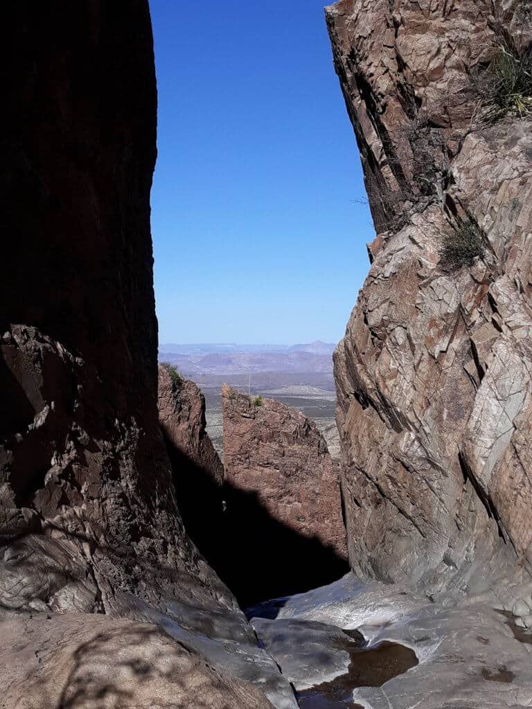
#6: The Window Trail – Big Bend National Park
- Trailhead Location
- Length: 5.2 miles out and back roundtrip
- Rating: Moderate – this hike contains almost 1,000 feet in elevation gain, and requires climbing some natural stairs near the end.
- Estimated Time to Complete: 2 – 2.5 hours
- Fees: $30 per vehicle
The Window Trail makes the list for the picturesque surprise waiting at the end of this hike – one of the best natural “windows” in Texas! The Window Trail starts by traversing the open expanses of Big Bend National Park, before gradually narrowing between canyon walls and climbing natural rock stairs, until you reach the iconic framed “window”!
***Learn more about the iconic Window Trail in Big Bend National Park here!

#7: Haynes Ridge and Upper North Prong Trail – Caprock Canyons State Park
- Trailhead Location
- Length: 6.3 mile loop roundtrip
- Rating: Moderate – There is 856 feet of elevation gain here, and the trail is also largely exposed with little shade, so caution in regards to the elements must be exercised!
- Estimated Time to Complete: 2.5 – 3.5 hours
- Fees: $5 per person
Caprock Canyon is a local favorite among west Texans, and many love that it has so far remained largely a local gem! However, humble Caprock Canyon boasts some major red rock views, which lands it a spot on the list of best hikes in Texas! Hiking trails in this state park traverse the canyon floors riddled with rock formations and dry streambeds carving through the walls of Caprock, as well as the canyon rims above, offering breathtaking views of yet another amazing canyon in west Texas! The Haynes Ridge and North Prong Loop Trail is one such trail that just so happens to wind through bison territory, where you’re likely to witness members of the local herd. This “lollipop” loop trail begins in striking open canyon land, then climbs rapidly up the canyon ridge to the top of Haynes Ridge, before connecting the North Prong Loop. On the North Prong, hikers can check out the short spur trail to Fern Cave. Continue on through a forested riverbed, before being greeted once again to a dramatic expanse of red rock. It might not be the biggest canyon in Texas, but it should be no surprise that Caprock Canyon is home to some of the best hikes in west Texas!
***Learn more about exploring Caprock Canyon State Park here!

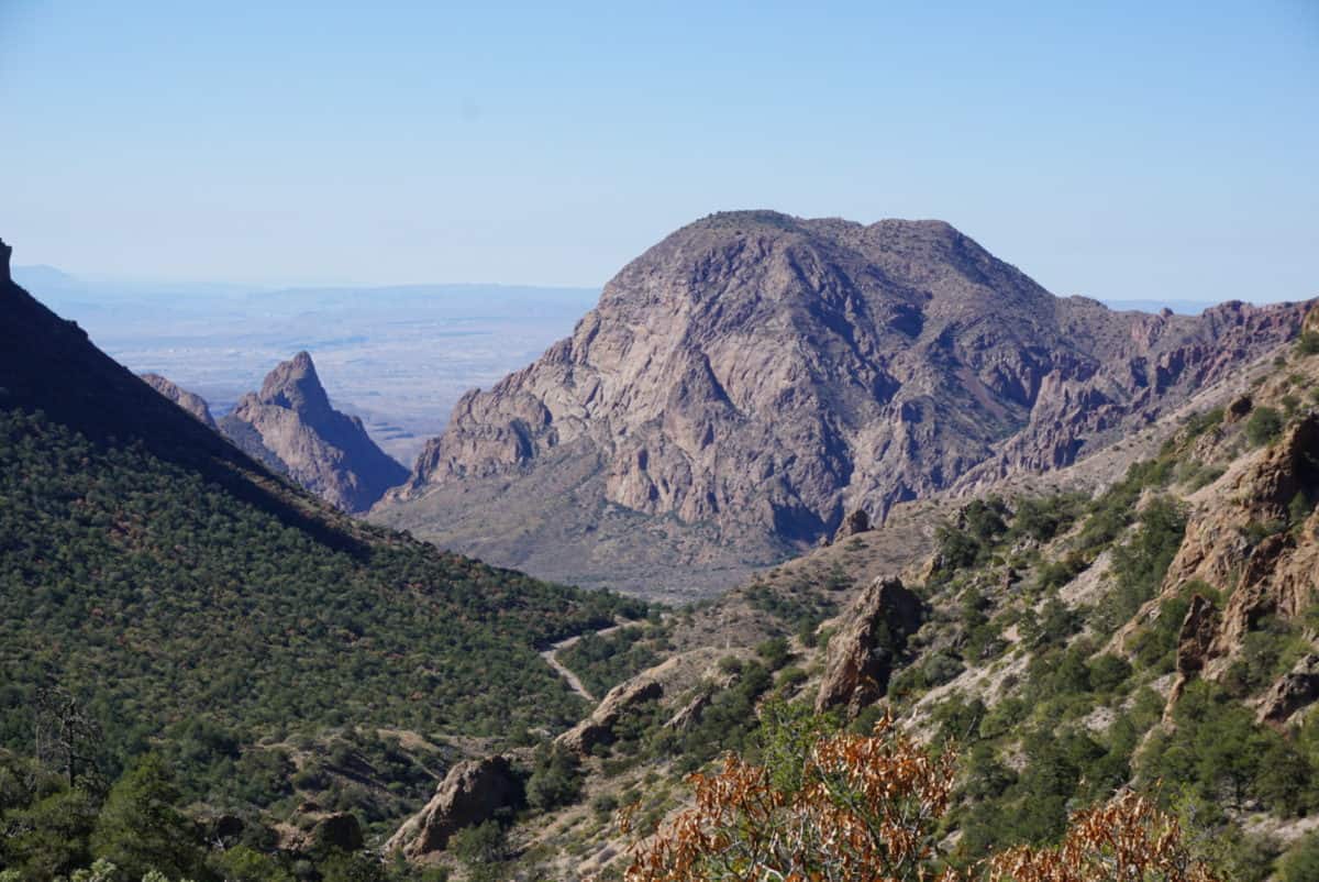
#8: The Lost Mine Trail – Big Bend National Park
- Trailhead Location
- Length: 4.8 mile out and back roundtrip
- Rating: Hard – the Lost Mine Trail climbs just over 1,000 feet in less than 2.5 miles, so the incline is substantial, though it is consistent and non technical.
- Estimated Time to Complete: 2.5 – 3.5 hours
- Fees: $30 per vehicle
This short trail located in Big Bend National Park really gives you a lot of bang for your buck! It may be short, but it climbs quickly and substantially, thus guaranteeing lofty views that you would not expect from the beginnings of this trail! The summit is quintessential Big Bend, and is one of the best views in all of west Texas! Be sure to stop on the expansive and relatively flat summit for a breather when you reach the top! This is a popular park trail, with limited parking, so plan to arrive early.
***Learn more about hiking the Lost Mine Trail here!

#9: Penitentiary Hollow Trail – Mineral Wells State Park
- Trailhead Location
- Length: 1.2 mile out and back roundtrip
- Rating: Easy – there is some rocky terrain to watch for, but the trail itself is relatively flat and consistent, with a short length and low elevation gain.
- Estimated Time to Complete: 1 -1.5 hours
- Fees: $7 per person
The Penitentiary Hollow Trail is a favorite spot for those city Texans residing in Dallas and Fort Worth, looking for an escape that’s close by! Penitentiary Hollow is the highlight of Lake Mineral Wells State Park, one of the best state parks near DFW! Enjoy the scenic lake views and cliffs along this park trail.

#10: McKittrick Canyon – Guadalupe Mountains National Park
- Trailhead Location
- Length: 20.2 miles out and back roundtrip
- Rating: Hard – that is, if you choose to do the whole 20 miles and over 4,000 feet of total elevation gain! You can do less if you’re in the mood for a shorter day hike. 8 miles will get you to both historic cabins and the “Grotto”!
- Estimated Time to Complete: recommended overnight backpacking trip (or hike to a shorter “turn around” spot like the Pratt Cabin, Hunter Line Cabin, or Grotto.)
- Fees: $10 per person
McKittrick Canyon is an exhilarating hike year round, but if you really want to experience it at its prime, go in the fall, when the autumn colors of this canyon trail rival those found in the northeast! It is quite a refreshing surprise to find this display of beauty in the corner of west Texas! Also found along the trail are several nods to the history of early Texas, as evidenced by the Pratt and Hunter Line cabins still in existence on the McKittrick Canyon Trail. And of course, you don’t want to miss out on “the Grotto” formation!
This trail can be experienced both as a day hike, or as an overnight backpacking hike! If you follow all 20 miles of its trail, you will have climbed to the ridge of the canyon, which offers some rewarding views from above for those planning to make a night out of it!
***Learn more about day hiking McKittrick Canyon in Guadalupe Mountains National Park here!

#11: Emory Peak – Big Bend National Park
- Trailhead Location
- Length: 10.4 miles out and back roundtrip
- Rating: Hard – the 2,500 feet of elevation gain on this summit hike speaks for itself! And then there is the slightly technical scramble up the last sheer rock wall for about 25 feet.
- Estimated Time to Complete: 5 – 7 hours
- Fees: $30 per vehicle
Big Bend National Park is not short on its offerings of great summit views and mountain hikes, and Emory Peak is another park favorite for those looking for a challenge! The slightly technical ending to this climb equals less crowds and more solitude, if that is what you are craving! The scramble up the short rock wall at the end does have some drop offs, but it does not require any technical background or technical gear, just extra care and careful pacing. Oh, and this is the tallest peak in Big Bend National Park as an added bonus!

#12: Rio Grande Trail – Seminole Canyon State Park
- Trailhead Location
- Length: 7.6 mile loop roundtrip
- Rating: Easy – though the length is substantial, the terrain is straightforward and the elevation gain is minimal, equaling an almost consistently flat trek.
- Estimated Time to Complete: 2 hours and 45 minutes – 3.5 hours
- Fees: $4 per person
Seminole Canyon State Park resides in the very far southern pocket of Texas, an area that is largely unknown for its hiking. But Seminole Canyon State Park makes it on the list of best places to hike in Texas because it boasts a trail that is easily worth the road trip – the Rio Grande Trail! You probably won’t be expecting the jaw-dropping views of the Rio Grande River when you begin this hike. This canyon rim hike is aptly named, as it runs parallel along the top of Seminole Canyon, overlooking the giant Rio Grande below.
Seminole Canyon additionally boasts a wealth of ancient cave art, that can be explored by its visitors, as well as other fun state park activities and additional hikes!
***Learn more about visiting Seminole Canyon State Park and Historic Site here!

#13: Lost Maples East Trail – Lost Maples State Natural Area
- Trailhead Location
- Length: 5.2 mile loop roundtrip
- Rating: Moderate – about 600 feet of elevation gain on this loop trail make the lost Maples East Trail just a bit more moderate.
- Estimated Time to Complete: 2 – 3 hours
- Fees: $6 per person
The Lost Maples East Trail is another autumn hiking favorite, due to its falls colors really livening up this corner of Texas hill country! Enjoy hiking among boulders and below cliffs, along the idyllic Sabine River! The namesake maples along this trail offer a peaceful canopy, as visitors cross shallow river beds, small waterfalls, and scenic overlooks! This trail really does offer a handful of surprises to its visitors.

#14: Eagle Point Trail – Caprock Canyons State Park
- Trailhead Location
- Length: 4.3 miles out and back roundtrip
- Rating: Easy to Moderate – there is some sections of moderate incline on this trail that contains 449 feet of elevation gain.
- Estimated Time to Complete: 1.5 – 2 hours
- Fees: $5
If you are looking to explore some unique geography and geology that is prevalent in west Texas, the Eagle Point Trail in Caprock Canyons State Park is one of the best! Here you can find gypsum deposits embedded in the earth, a “natural” bridge, and a cave large enough for exploration! It is a fun and visually stimulating hike found in the heart of west Texas’s grandest canyon-scapes!

#15: Ol’ Baldy – Garner State Park
- Trailhead Location
- Length: 1 mile out and back roundtrip
- Rating: Moderate to Hard – I would consider this trail largely moderate, but consideration must be given to the fact that this half a mile climb has an elevation gain of over 400 feet.
- Estimated Time to Complete:
- Fees: $8 per person
While Ol’ Baldy may not boast the climbs of a 14’er, it makes the most of its humble surroundings in central Texas, and provides some pretty impressive views with equally impressive drop offs and panoramas, on the list of best places to hike in Texas!

#16: El Paso Tin Mines Trail – Franklin Mountains State Park
- Trailhead Location
- Length: 6.6 miles out and back roundtrip
- Rating: Moderate – this hike is mostly flat and consistent, right up until the end. The last section does require a bit of moderate incline and climbing to reach the abandoned tin mines, which are embedded into the side of the mountain.
- Estimated Time to Complete: 2.5 – 3.5 hours
- Fees: FREE
Another addition to the best hikes in Texas list that is largely unknown – the El Paso Tin Mines Trail in Franklin Mountains State Park! You’ll have to travel to the far western reaches of Texas to find this one, but you’ll be accomplishing a very unique hike in doing so!
The El Paso Tin Mines Trail terminates at the only and now abandoned tin mines in the United States, and the highlight of this hike is actually being able to explore them up close and in person when you hike this trail! So be sure to bring along your flashlight! The surrounding backdrop of the rugged Franklin Mountains doesn’t hurt either, and is a constant reminder that, unbeknownst to many, there are several great mountain ranges in Texas!
***Learn more about all the hikes in Franklin Mountains State Park here!

#17: Gorman Falls – Colorado Bend State Park
- Trailhead Location
- Length: 2.8 miles out and back roundtrip
- Rating: Moderate – this trail is pretty rocky and steep near the end.
- Estimated Time to Complete: 1 hour
- Fees: $5 per person
Gorman Falls is a fan favorite of best places to hike in Texas because of its namesake falls, one of the most gorgeous in the Lone Star State! Be prepared for rocky, slippery, and steep sections as you make your way to the falls. As one of the more popular hikes in Colorado Bend State Park, advance booking for park entrance is recommended, especially on the weekends.
And there you have it, a complete list of the 17 best hikes in Texas!
Want to Explore More of Texas?
Check Out Some of My Texas Favorites:
- Guadalupe Mountains National Park Guide
- 8 Best Guadalupe Mountains National Park Hikes
- 10 Best Big Bend National Park Hikes
- One Day in Big Bend National Park Itinerary
- 3 Day Itinerary for Big Bend National Park
- Best Hikes in West Texas
- Guide to Monahans Sandhills State Park
- Best Hikes in El Paso
- 20 Best Half Marathons in Texas
- Best Trail Races in Texas
PIN for LATER!