The Absolute Best Hiking in West Texas
West Texas holds a special place in my heart. Not only because it is my home state, but because this region of Texas is so truly diverse. Most people think that West Texas is just flat and boring, but that couldn’t be further from the truth! In my explorations to discover the very best hiking in West Texas, I have experienced canyons, rivers, forests, deserts, and mountaintops, that you wouldn’t believe were here! If you are interested in taking on a journey to an under-rated yet mesmerizing corner of our country, check out my list of the best hiking in West Texas!
- #1: The Lighthouse Trail in Palo Duro Canyon State Park
- #2: Santa Elena Canyon in Big Bend National Park
- #3: The Window Trail in Big Bend National Park
- #4: The Lost Mine Trail in Big Bend National Park
- #5: Guadalupe Peak in Guadalupe Mountains National Park
- #6: Seminole Canyon in Seminole Canyon State Park and Historic Site
- #7: Eagle Point Trail in Caprock Canyon State Park
- #8: The Haynes Ridge Overlook Trail in Caprock Canyon State Park
- #9: El Paso Tin Mines Trail in Franklin Mountains State Park

Table of Contents
The BEST Hiking in West Texas
From state parks to National Parks, from the bottom of canyon chasms to the highest point in the state, this is the list of the top 9 trails for the best hiking in West Texas!
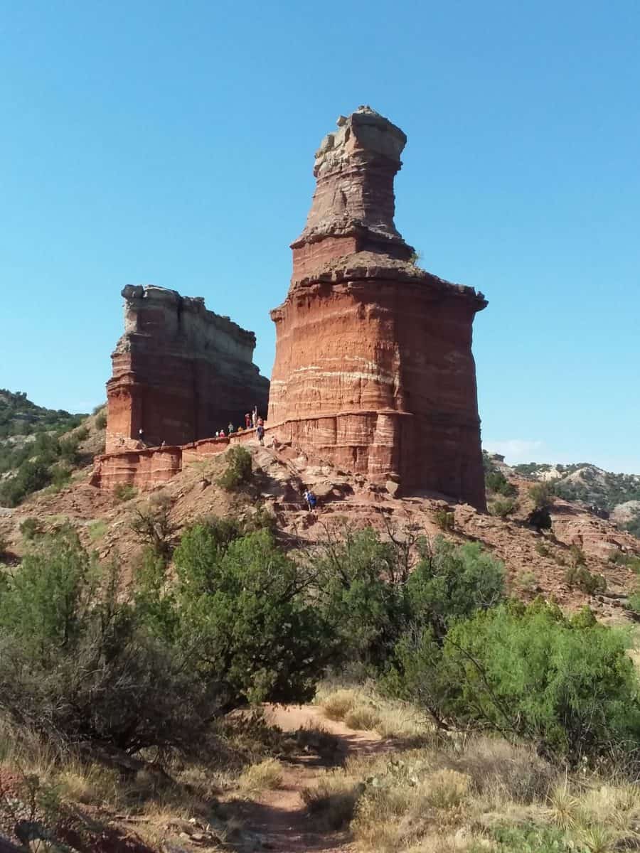
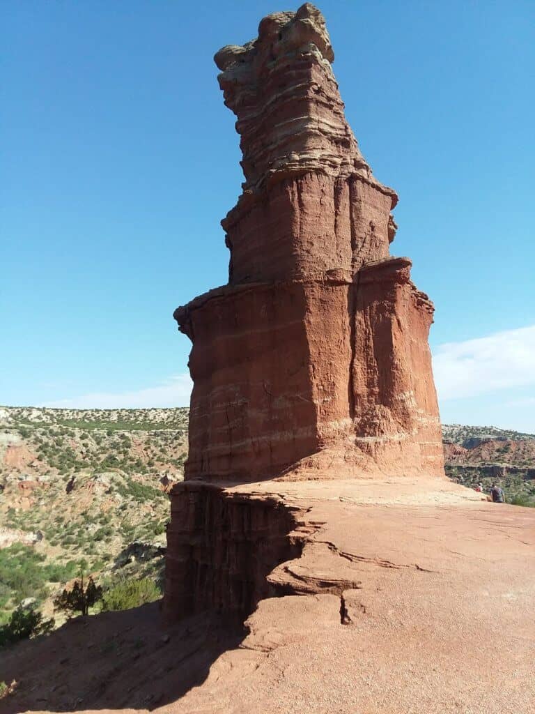
#1: The Lighthouse Trail in Palo Duro Canyon State Park
Kicking off the tour of best hiking in West Texas is the iconic Lighthouse Trail, found in the little sibling of Arizona’s Grand Canyon, Palo Duro Canyon State Park. Palo Duro Canyon is a treasure trove of canyon hiking because it is actually the 2nd largest canyon in the United States! If you love being surrounded by towering red rock cliffs and striated canyon walls, then you will love the most beloved hike here in Palo Duro Canyon State Park, the Lighthouse Trail.

Quick Facts on the Lighthouse Trail
Length: 6 miles out and back roundtrip
Elevation Gain: 521 feet

Rating: Moderate – there is some elevation gain, especially the final climb to the plateau beneath the “lighthouse” formation. This final climb includes some narrow boulder hopping as well. However, the majority of the trail tends towards consistent and mostly flat, however, the moderate rating also comes from the length (6 miles roundtrip), and the elements, especially in the summer when the heat can be brutal and the shade lacking.
Estimated Time to Complete: 2 hours
Dog Friendly: The terrain and elevation gain are manageable for dogs with experience with hiking, but make sure that your dog is used to 6 miles roundtrip. Exercise extreme caution in the summer months, starting in May, when bringing your dog on the Lighthouse Trail. Temperatures can soar, and there is no shade. Even the most experienced pup will struggle if you are not adequately prepared with at least a liter of water for your pup. If you do hike with your pup in the warmer months in Palo Duro Canyon, start early and finish early!
Fees: entrance fees are $8 per person (13 and older)
Parking/Facilities: There is ample parking at the trailhead. There are no bathrooms.
Best Time of Year to Hike: Spring and Fall
So why do both locals and visitors alike love the Lighthouse Trail? It’s a superb example of the diversity of West Texas, first off. The striking canyons that many are not aware exist here put on an impressive show. The wildlife is abundant here, with lizards, snakes, birds, and deer on display. I have witnessed horned toads, deer, hawks, and speckled king snakes myself while hiking in Palo Duro Canyon. But most importantly, is the namesake “lighthouse” formation for which this trail is named after.

The “lighthouse” formation will become visible in the distance part way into the hike, but it is most breathtaking at its base. Luckily for hikers, you can get right up beneath the “lighthouse”, and enjoy views on the elevated and expansive plateaued base on which it rests. Not only are views of the formation itself worth the trip, but don’t forget to look around and take in the stunning panoramic views of Palo Duro Canyon surrounding the Lighthouse. It’s a viewpoint of Texas you won’t soon forget!
***Learn more about the Lighthouse Trail here
#2: Santa Elena Canyon in Big Bend National Park
Speaking of canyons in Texas, another example of the best hiking in West Texas can be found at another iconic canyon. This time in one of Texas’s TWO National Parks! Santa Elena Canyon in Big Bend National Park is one of the most recognizable views in Texas. And unlike Palo Duro Canyon previously, Santa Elena Canyon mixes in some waterworks with its impressive canyon hiking.

Quick Facts on the Santa Elena Canyon Trail
Length: 1.7 miles out and back roundtrip
Elevation Gain: 610 feet

Rating: Easy – there is some climbing for those that wish to trek all the way to the termination of the trail, but Santa Elena Canyon itself is accessible to almost every visitor in some way. You can hike the short distance from the parking lot to the shoreline of the Rio Grande, or continue on to finish the entirety of the Santa Elena Canyon Trail.
Estimated Time to Complete: 45 minutes
Dog Friendly: No, because dogs are not allowed on hiking trails in Big Bend National Park
Fees: Entrance fees are $30 per vehicle (good for 7 consecutive days)
Parking/Facilities: there is parking and bathrooms at the trailhead
Best Time of Year to Hike: Fall – Spring
This canyon hike impresses largely due to the sheer enormity and stark contrast with the mighty Rio Grande River that it encompasses. There is perhaps no better viewpoint of this river in Texas than from the Santa Elena Canyon Trail (though I’ll be making a case later in this list for Seminole Canyon State Park!). And on the Santa Elena Canyon Trail, you can choose to witness the harmonious views of this river and canyon from the shoreline, from above, or from both!
An added bonus of the Santa Elena Canyon is that not only is it a must see for hikers, but it also offers the chance to kayak as well, for those that may want to add a Santa Elena Canyon kayaking venture on to their itinerary!

#3: The Window Trail in Big Bend National Park
Also found in Big Bend National Park, the Window Trail provides one of the best views of hiking in West Texas from its namesake “window”! This trail is unique in its characteristics, but the highlight absolutely comes at the end of the trail!

Quick Facts on the Window Trail:
Length: 5.2 miles out and back roundtrip
Elevation Gain: 948 feet

Rating: Moderate – a gain of almost 1,000 feet spread out over 5-ish miles is quite manageable and consistent. There is a need to exercise a little more cautious footwork as you get nearer the “window” and the trickier terrain of the rock “stairs”.
Estimated Time to Complete: 1 hour 45 minutes
Dog Friendly: No, since dogs are not allowed on hiking trails in Big Bend National Park.
Fees: Entrance fees are $30 per vehicle (good for 7 consecutive days)
Parking/Facilities: there is parking and bathrooms near the trailhead
Best Time of Year to Hike: Fall – Spring
The Window Trail begins as an open and airy trek through Big Bend National Park. The trailhead is easily accessible from the Chisos Basin Campground. As the trail weaves on, the neighboring canyon walls find themselves merging closer and closer to the trail, until you begin to walk in their shadows. The trail parallels a stream on the left side, with towering walls overlooking the trail. The end of the trail will find you climbing natural “staircases” and traversing pools of water and gentle streams navigating the rocks, until you reach the end, the famous “window” of the Window Trail!

The “window” is really where the canyon walls finally merge together in a sheer dropoff, but from this dropoff, a rock window is formed overlooking a stunning expanse of Big Bend National Park backcountry! Just be sure to take caution not to venture too far to the edge of the “window” and its dropoff to the depths below!
***Learn more about the Window Trail here
#4: The Lost Mine Trail in Big Bend National Park
Closing out the best hiking in West Texas located in Big Bend National Park is the Lost Mine Trail! Unlike the former canyon-esque hikes on this list, the Lost Mine Trail takes you up into the heavens, with viewpoints overlooking Big Bend National Park!
 Views along the Lost Mine Trail in Big Bend National Park
Quick Facts on the Lost Mine Trail:
Length: 4.8 miles out and back roundtrip
Elevation Gain: 1,131 feet

Rating: Difficult – the Lost Mine Trail may be relatively short, but it packs a punch! The elevation gain is steep and consistent, and in order to reach the heights of the Lost Mine Trail’s terminating plateau, that means that steepness and consistency can’t really afford to let up as you climb! So be prepared for a workout, with views that are worth it in the end!
Estimated Time to Complete: 1 hour 30 minutes – 1 hour 45 minutes
Dog Friendly: No, since dogs are not allowed on hiking trails in Big Bend National Park
Fees: Entrance fees are $30 per vehicle (good for 7 consecutive days)
Parking/Facilities: there is very limited parking at the trailhead, and it fills up quickly, so arrive early. There are no bathrooms.
Best Time of Year to Hike: Fall – Spring
The Lost Mine Trail’s endearing qualities come from its innate challenging nature, for those looking for a shorter day hike that still offers the challenge of a full mountain hike! The higher you climb on the Lost Mine Trail, the more the views impress! It truly is a hike for those that appreciate mountain viewpoints! The final treat comes at the top, when the Lost Mine Trail arrives at a large, flat, expanse of rock, a perfect spot for a rest and snack, and the perfect backdrop for pictures containing the best views from above of Big Bend National Park!
***Learn more about the Lost Mine Trail here

#5: Guadalupe Peak in Guadalupe Mountains National Park
When you are the highest point in the great state of Texas, you are bound to make the list for best hiking in West Texas (and the whole state as well for that matter)! Guadalupe Peak in Guadalupe Mountains National Park literally towers over the rest of hiking in West Texas as the state high point of Texas! It also does a fantastic job of bringing attention to the incredible hiking opportunities that exist in Texas’s lesser known other National Park!

Quick Facts on Guadalupe Peak:
Length: 8.4 miles out and back roundtrip
Elevation Gain: 2,952 feet

Rating: Difficult – it is a climb to a summit of 8,751 feet in elevation, so it is going to naturally take some work to get there. The first half of the hike is actually harder than the second half, according to most hikers, including myself.
Estimated Time to Complete: 6 – 8 hours
Dog Friendly: No, since dogs are not allowed on hiking trails in Guadalupe Mountains National Park.
Fees: $10 per person
Parking/Facilities: There is ample parking at the trailhead. There are bathrooms at the trailhead.
Best Time of Year to Hike: Fall and Spring
Guadalupe Peak is literally one of my favorite hikes in the country, not just hiking in West Texas! It was this peak that started my own personal adventure to continue trekking other state high points around the U.S. (now currently sitting at #45 out of 50!)
Guadalupe Peak is a fascinating blend of topography, terrain, and ecosystems that you wouldn’t expect to find in this far west corner of West Texas. Most people assume that you would just find flat desert here, but the Guadalupe Peak Trail completely disproves that myth!
The Guadalupe Peak Trail starts off in the shrub laden expanses of the Chihuahuan Desert. The first couple miles of climbing are actually the most arduous part of this hike! However, once you conquer those first couple miles, and wind around the face of the mountain via a narrow cliff edge traverse, you will find a whole other world on the backside of Guadalupe Peak!
Here shady Ponderosa towers emerge, dappling the trail with sunlight as it continues up. As you climb higher, you’ll encounter more signs of high desert life, until emerging towards the top of Guadalupe Peak and the weather worn rock boulders and plateaus that make up its summit. There is even a backcountry primitive campsite just shy of the summit, for those looking for a little extra adventure on Guadalupe Peak!
From the very top at 8,751 feet in elevation, you can see the neighboring summit of El Capitan’s peak, the rest of Guadalupe Mountains National Park, and even the Salt Flats glimmering in the distance!

Don’t assume that the rest of Guadalupe Mountains National Park doesn’t also contain other examples of some of the best hiking in West Texas! While you’re there checking out Guadalupe Peak, don’t miss out on the ominous sounding Devil’s Hall Trail, or the long distance McKittrick Canyon Trail, a real showstopper in the fall when surprisingly vibrant autumn colors emerge!
***Learn more about the Guadalupe Peak Trail here
#6: Seminole Canyon State Park and Historic Site
To enjoy some of the best hiking in West Texas in its most southern reaches, travel down to Seminole Canyon State Park and Historic Site! This humble hidden gem of hiking in West Texas owes its spot on this list to the less humble and less hidden Rio Grande River, which is the highlight of hiking in Seminole Canyon State Park! All the trails here really intertwine to make the most of hiking in conjunction with the Rio Grande River, but if I were to choose one that really highlights the park, it would be the Rio Grande Trail.
 Overlooking the Rio Grande River in Seminole Canyon
Quick Facts on the Rio Grande Trail:
Length: 7.6 miles roundtrip loop
Elevation Gain: 301 feet

Rating: Easy
Estimated Time to Complete: 2 hours and 30 minutes
Dog Friendly: Yes
Fees: entrance fees are $4 per person (13 years and older)
Parking/Facilities: there is parking available at the trailhead. There are no bathrooms directly at the trailhead, but there are bathrooms nearby in the Desert Vista Campground or at the Visitor Center.
Best Time of Year to Hike: Fall – Spring
From the entrance, it may not appear that there is that much going on at Seminole Canyon State Park. But take a trek along the Rio Grande Trail, and you will be in for a breathtaking and unexpected surprise.
The views looking down on the Rio Grande River give Santa Elena Canyon’s views a real run for their money! But it is truly the unexpectedness that impresses the most! Getting the chance to stand atop the rim of Seminole Canyon and look down at the gaping chasm below that houses this mighty river is a truly unique viewpoint! It is easily one of the most unforgettable views I have had while hiking in West Texas!

The added bonus of Seminole Canyon State Park is the chance to discover what is hiding below in the canyon walls. Early rock art can be explored on tours given by the state park, such as Panther Cave, and even further highlight the surprising discoveries to be had here at Seminole Canyon State Park!
***Learn more about Seminole Canyon State Park and Historic Site here
#7: Eagle Point Trail in Caprock Canyons State Park
Caprock Canyons State Park is a local favorite. It resides in the shadows of nearby Palo Duro Canyon State Park, which tends to garner slightly more attention due to its designation as the 2nd largest canyon in the United States, second only to the Grand Canyon! However, those that have hiked in both these West Texas canyons would argue that Caprock Canyons State Park is endearing in its own way, and easily stands side by side to Palo Duro Canyon! One of the highlights here at Caprock Canyons State Park – the Eagle Point Trail!

Quick Facts on the Eagle Point Trail:
Length: 4.3 miles out and back roundtrip
Elevation Gain: 449 feet

Rating: Easy to Moderate
Estimated Time to Complete: 1 hour and 30 minutes
Dog Friendly: Yes, but exercise caution in the summer months due to the extreme temperatures and minimal shade!
Fees: entrance fees are $5 per person (13 years and older)
Parking/Facilities: there is parking near the trailhead, but requires a short walk. There are no bathrooms directly at the trailhead, but are nearby at the Visitor Center, Lake Theo Campground, or Interpretive Center.
Best Time of Year to Hike: Fall and Spring
The Eagle Point Trail is full of unique discoveries to make, from the striking red rock scenery, to the gypsum deposits that dot the trail, to the “natural bridge” and mysterious cave it traverses!
The Eagle Point Trail begins as an easy and flat hike through the open red rock surroundings of the interior of Caprock Canyon State Park. Along the way, you will have a chance to witness up close some of the unique geology of Caprock Canyon, the sparkling gypsum deposits!

A short ways into the hike you will come to the “natural bridge” that this trail is highlighted for. But don’t miss out on taking a side detour underneath the bridge, where you will find a cave large enough for exploring!
The rest of Eagle Point Trail contains some easy to moderate ups and downs, and much more striking red rock on display for its visiting hikers!
***Learn more about Caprock Canyons State Park here
#8: Haynes Ridge Overlook Trail in Caprock Canyon State Park
The Haynes Overlook Trail is for those that want those birds eye views of Caprock Canyon State Park! Be prepared to put in the work for those views, but the payoff will be worth it! The Haynes Overlook Trail is connected to the Canyon Loop Trail and the Upper Canyon Trail.

Quick Facts on the Haynes Ridge Overlook Trail:
Length: 6 miles roundtrip loop (this includes Canyon Loop Trail, Haynes Ridge Overlook Trail, and Upper Canyon Trail, since together these 3 trails form a loop).
Elevation Gain: 820 feet

Rating: Moderate – this hike is mostly flat, with one large climb to a plateau. This climb is decently steep and would be considered minor boulder and rock scrambling by some
Estimated Time to Complete: 2 hours – 2 hours and 30 minutes
Dog Friendly: Yes, if your pup is used to and comfortable with some degree of uphill climbing and rougher, rockier terrain.
Fees: Entrance fees are $5 a person (13 years and older)
Parking/Facilities: There is ample parking at the trailhead. There are no bathrooms directly at the trailhead, but there are bathrooms at the nearby campgrounds or at the Visitor Center.
Best Time of Year to Hike: Fall and Spring
The highlight of the Haynes Overlook Trail is definitely the climb to the top of the ridge and its rewarding views, but the journey getting there is also a treat! There’s plenty of red rock cliffs to enjoy, interesting formations to behold, and you may even catch a glimpse of a resident bison joining you trailside here in Caprock Canyon’s backcountry!

Once you reach the top of the ridge along the Haynes Overlook Trail, you will be rewarded with views for miles, overlooking all the gorges, walls, and cliffs that make up this beautiful park, and make it some of the best hiking in West Texas! Don’t miss Fern Cave, a short offshoot along the trail! This cave is hewn into the side of a cliff, and contains ferns that are growing and clinging to its sides!
The great thing about the Haynes Overlook Trail, and most of the trails in Caprock Canyons State Park, is that it can be combined with other trails for even longer ventures in this park!
#9: The El Paso Tin Mines Trail in Franklin Mountains State Park
The El Paso Tin Mines Trail, found in Franklin Mountains State Park, is largely unheard of, but it deserves a spot on this list of best hiking in West Texas, just due to its uniqueness! Plus, it is just one of a handful of outstanding and under-rated trails in the outdoor playground that is El Paso’s best hiking trails!

Quick Facts on the El Paso Tin Mines Trail:
Length: 6.6 miles out and back roundtrip
Elevation Gain: 1,023 feet

Rating: Moderate – there is some degree of uphill elevation gain, and the hike is slightly longer at almost 7 miles.
Estimated Time to Complete: 2 hours and 30 minutes
Dog Friendly: Yes, leashed pets are welcome, but exercise caution in the hotter summer months!
Fees: Entrance fees are $5 a person (13 years and older)
Parking/Facilities: There is ample parking at the trailhead. There are bathrooms at the trailhead.
Best Time of Year to Hike: Fall and Spring
I personally discovered the El Paso Tin Mines Trail more on accident, when I spent a weekend camping in Franklin Mountains State Park. This park contains some great hiking in West Texas, because it contains such an engaging mountain chain in the Franklin Mountains. These mountains house some challenging and diverse hiking in this corner of West Texas.
The El Paso Tin Mines Trail, however, gets its name from the fact that there is an actual abandoned tin mine at the termination of the trail! And in fact, they are the only tin mines of their kind to ever exist in the U.S., which literally makes this a one of a kind hike! And even better, you can actually venture inside the abandoned tin mines, so you may even want to bring a flashlight along with you for this hike so you can witness the interior walls of the mine, glittering with specks of minerals, up close and personal!
To find the trailhead, park in the parking lot, climb the concrete dam, and then proceed down the jeep road trail until you turn left to continue down the El Paso Tin Mines Trail. The El Paso Tin Mines Trail starts off relatively flat and open, traversing the desert scenery. It does begin to climb as it continues, until you climb the side of the mountain to the spot that houses the tin mines. Look for the orange rock structure with the grated metal roof, half buried in the side of the mountain, just after passing signage for Mundy’s Gap (another great hike in the area)!
The interior of the tin mines is relatively small, but it is unique and piques the curiosity of every visitor, with a slightly eerie vibe! It can be explored in a few minutes, but you’ll remember it for far longer! And don’t forget to take in the amazing mountain views surrounding the tin mines!
***Learn more about Franklin Mountains State Park here
 First mile of the El Paso Tin Mines Trail
What Gear Do You Need for Hiking in West Texas?
West Texas is rugged and rough, and that is exactly what creates the exhilarating mountain ranges, the deep canyons, the forests, the deserts, and the rivers! Bring along a couple pieces of key hiking gear, and you are guaranteed to have a safe, responsible, and enjoyable time hiking all these best hikes in west Texas!
- Hiking Boots or Trail Runners:
Make sure to take proper care of your feet on these west Texas hikes!
- For traditional hiking boots, I recommend the waterproof Vasque Breeze GTX III boots
- For lighter, faster trail runners, I recommend the ultra cushioned Hoka One One Speedgoats
- Day Pack:
All the trails mentioned on this list of the best hikes in west Texas are all day hikes. Be sure to use a day pack that has ample space for all your day hiking gear, plus whatever water system you plan to use to ensure you carry plenty of water with you at all times!
- I recommend the Osprey Daylite Daypack or the Camelback Helena Daypack (both are water bladder compatible)
- Water System:
Speaking of water, make sure to bring plenty, as west Texas is a dry region with strong sun, even in the winter. Many of these west Texas hiking trails will not have reliable water sources along the trail either. When hiking in the rugged wilderness of west Texas, I always bring 2 – 3 liters of water minimum.
- I recommend the Platypus 3 Liter Water Hydration Bladder ( I love this model with its wide mouth, which makes filling, emptying, drying, and cleaning much simpler and quicker!)
And there you have it, the best hiking in West Texas that you can’t afford to miss! Be sure to check out these related articles to keep the inspiration going!
RELATED ARTICLES:
Mountains in Texas: Fact or Fiction?
15 Fresh Ways to Spend Spring Break in Texas
The 8 Best State Parks for Camping and Hiking Near Dallas
PIN for LATER!


My son and I went to the Davis Mountains Preserve 2 weekends ago and hiked up Mount Livermore/Baldy Peak. The hike was strenuous but the payoff was amazing. Clear skies, we could see the Guadalupe Mountains to the north, Marfa to the southeast, Big Bend looming to the south.
Sounds like a great hike Michael! I was just in the Davis Mountains this past weekend myself, and did a couple of hikes in the Davis Mountains National Historic Site, as well as the Davis Mountains State Park! I love the area, great views and vistas, and you’re absolutely right about the payoffs being amazing! Mount Livermore is actually on my to do list during one of my next visits. Have you also had a chance to visit the Guadalupe Mountains and/or Big Bend?