Guide to the Lost Mine Trail at Big Bend National Park
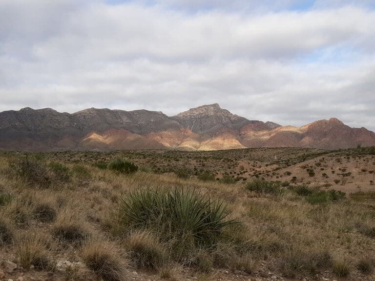
There is a common misconception floating around out there that the state of Texas is all just flat and boring! One of the best examples I have seen that completely shatters this untruth to its core is the Lost Mine Trail at Big Bend! This National Park is home to some of the most beautiful mountains in the Southwest, the Chisos Mountains range. These golden and rugged peaks erupt from the encompassing Chihuahuan desert, creating a haven of challenging hiking opportunities at high elevation, the best of which is the Lost Mine Trail!

Disclosure: Below are some affiliate links-these are all products I highly recommend. I won’t make any recommendations on this page that I haven’t tested or personally used!
Table of Contents
Guide to Hiking the Lost Mine Trail
- Location of the Lost Mine Trail in Big Bend National Park
- Know Before You Go
- Quick Facts
- Full Trail Report
- Recommended Gear
Location of the Lost Mine Trail
The Lost Mine Trail is located in Big Bend National Park. This exciting uphill trek is made all the more better because it resides in the indisputable supreme region of Big Bend, the Chisos Basin. This area cradles a unique ecosystem surrounded by the Chisos Mountains, which are home to many other standout hikes in addition to the Lost Mine Trail, like the iconic Window Trail. It is home to a diverse blend of topography, including forest, desert, and canyon terrain. The Lost Mine trailhead can be accessed adjacent to the Chisos Mountain Lodge, Chisos Visitor’s Center, and Chisos Basin Campground, making it centrally located and easily accessible to both day hikers and overnight campers alike.
Insider Tip: the one big downside to the Lost Mine Trail is the parking situation at the trailhead. There is a small parking area that can hold a dozen or so vehicles, but it fills up extremely quickly. Since the parking area and trailhead are located on a main park road on an uphill, there is also no good spot to park nearby and walk to the trailhead. Plan to arrive early, or plan to wait for a spot to open up.

Quick Facts on the Lost Mine Trail at Big Bend
Length: 4.8 miles roundtrip out and back
Rating: Moderate to Difficult
This hike contains just over two miles worth of steady, consistent uphill. The elevation gain is just over 1,000 feet, which is a decent amount in only two miles. The grade is moderate, but the only break comes at the saddle after the first mile. Also, the second mile of uphill is more exposed, and so it is important to take that into account. After reaching the top, the last couple miles returning are all downhill.
Elevation Gain: 1,131 feet

Estimated Time to Complete: 2.5 – 3 hours
Best Time of Year to Hike: Fall to Spring
You will want to take extreme caution when hiking in the summer months, as temperatures in Big Bend National Park can be brutal and dangerous!
Dog Friendly: No, unfortunately dogs are not allowed on any of the hiking trails at Big Bend National Park
Parking/Facilities: Parking is limited, so plan to arrive early or you may be waiting for a parking spot. There are no facilities at the parking lot or trailhead.
Fees: Entrance fees for Big Bend National Park are $30 per vehicle, and are good for 7 days.
Trail Report for The Lost Mine Trail
The Lost Mine Trail gives hikers a true treat, the chance to take on a challenging day hike, to bask in a high desert forest, to be overshadowed by unique rock formations, and to stand on the top of a Big Bend summit and be rewarded with the breathtaking views. There are a lot of great trails in this National Park, but the Lost Mine Trail is an ideal choice for those who want to challenge themselves, while being able to accomplish that uphill and high altitude feat in less than half a day.
The Lost Mine Trail doesn’t waste any time in gaining elevation. Right from the trailhead, this hike is an immediate uphill, and maintains a steady and moderately challenging grade for the first approximate mile. It proceeds uphill, with views through the foliage off to the left overlooking the rest of the Chisos Basin. This part of the trail is mostly shady, winding through a high elevation forest setting composed of juniper, oak, and pine.
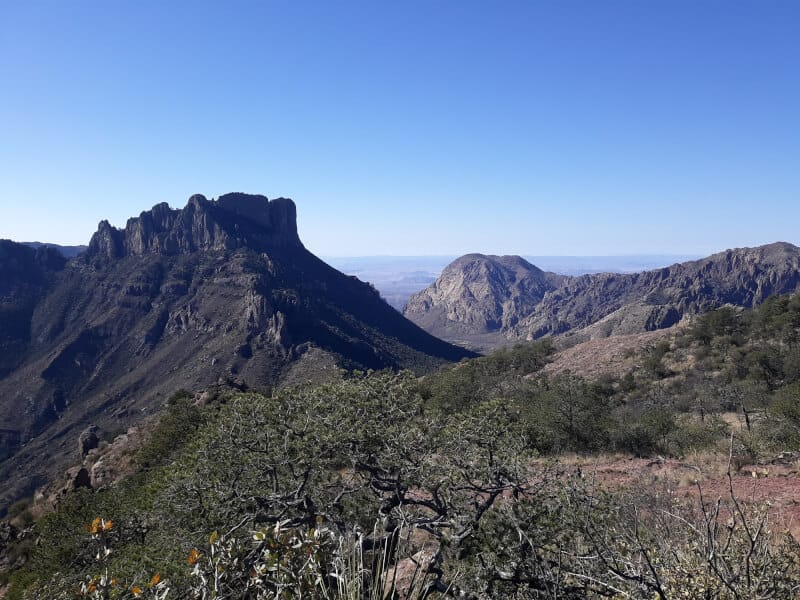
Some of the best views occur right around the completion of the first mile, when hikers reach a small saddle from which to look out over the opposite side of the range. A whole other side of Big Bend National Park and beyond is visible from this vantage point. Off to the right looms the Casa Grande rock formation, jutting into the sky. In the distance you can see the Chisos Mountains converging to create the magical “Window” found along the Window Trail. The Lost Mine Trail then continues off to the left of this saddle, and begins to increase its uphill grade slightly.

This second mile is slightly more challenging in its grade, though it remains consistent as the trail proceeds up a series of switchbacks towards the summit. Also, the high desert forest thins out substantially, and hikers are more exposed on this section, though that exposure makes the surrounding views all the more overwhelming.
You may hear from other sources that the saddle after the first mile contain the best views on this hike, but I will argue that strongly. The best views are at the summit, and it is completely worth making it there! The summit contains a enormous rock face that stretches amongst several smaller summits on the ridge. There are full 360 degree views here, and those views will make you fully appreciate what a high altitude hike in Texas can look like.
Also, it is quite impressive that a little over two miles approximately of uphill climbing can yield such impressive views, which is what makes this hike so appealing. It is a hike that is both challenging and doable. A relatively short hike, but with big payoff, and that makes it accessible to an even wider range of hikers.
That enormous rock face at the top of the Lost Mine Trail makes for a perfect spot to sit down and recharge with a snack )or a quick nap), while looking out over the rest of Big Bend National Park, and even the Sierra Del Carmen Mountains range in Mexico! Then it is all downhill from there, back down to the cradle of the Chisos Basin!


Recommendations for Hiking the Lost Mine Trail
- water, water, water! This recommendation is true for any hike in Big Bend National Park. This is a challenging uphill climb at high desert elevation, with some sections of the trail largely exposed to the sun. I would recommend bringing 3 liters of water. I use a Platypus water hydration bladder to carry my own 3 liters of water.
- hiking boots will come in handy on this hike, not only to give you stability on your uphill climb, but equally as important, to give you stability on your downhill descent, which can be just as challenging. I recommend the Vasque Breeze GTX III hiking boots that I have completed many uphill and rocky summits with.
BONUS: Get equipped to take on any hike on your bucket list with the only FREE hiking checklist you will ever need, containing all 10 hiking essentials plus extras!
PIN for LATER!