10 Best Hikes in Big Bend National Park
Why is Big Bend National Park a hiking mecca in the southwest? Because its trails are a tapestry of all the unique characteristics here in Big Bend, from mountain summits, to enormous canyons, to mighty rivers, to vast deserts, to steaming hot springs, and to a myriad of fascinating formations, including balancing rocks, tinajas, rock “stairways”, natural “windows”, and even mule ears! Find out just what makes each of these 10 best hikes in Big Bend National Park so special!

Disclosure: Below are some affiliate links-these are all products I highly recommend. I won’t make any recommendations on this page that I haven’t tested or personally used! Enjoy this guide to the 10 best hiking trails in Big Bend National Park!
Table of Contents
The 10 Best Hikes in Big Bend National Park
These 10 best hikes in Big Bend National Park are as diverse as the park itself. These include hikes to the tops of mountain peaks, hikes through canyons, hikes along rivers and springs, and hikes that contain quirky and memorable formations, like natural “windows”, balancing rocks, and even “mule ears”! One these trails, you will witness a unique piece of the puzzle that makes this region so stunning and fun as a whole!
The 10 Best Hiking Trails in Big Bend National Park:
- Santa Elena Canyon Trail
- Emory Peak Trail
- The Window Trail
- The South Rim Trail
- The Lost Mine Trail
- The Boquillas Canyon Trail
- The Ernst Tinaja Trail
- The Mule Ears Spring Trail
- Balanced Rock (via the Grapevine Hills Trail)
- The Big Bend Hot Springs Trail

What to Know Before You Go
Entrance Fees: $30 per vehicle
Hours: Big Bend is open 24 hours a day, every day
Closest Town(s): Terlingua, Marathon, Alpine, and Marfa (all in Texas)
Closest Airport(s): Midland Odessa International (3 hour drive) and El Paso International (4.5 hour drive)
Pet Policy: your pet can only go where cars can go – that means NO pets on trails!
Camping: all campgrounds in Big Bend National Park are by reservation only.
Best Time to Hike in Big Bend National Park
Big Bend National Park is home to some extremes, when it comes to the seasons, and this can naturally affect when is the best time to hike in Big Bend National Park.
The overall best time to hike are the shoulder seasons of spring and fall, when the temperatures are mild and moderate, and there are less chances for any extreme weather patterns. If you choose to camp overnight in addition to hiking, this is also the most favorable time of year for sleep outside.
Summer can be unbearably brutal in Big Bend National Park, and extended hiking, especially in the later part of the day, is not advised. If you do plan to hike in the summer, start early, finish early, and make sure to bring plenty of water, snacks, breathable fabrics, and sun protection in the form of a hat and sunscreen.
Winter in Big Bend, despite its southern location, can still bring frigid temperatures, harsh winds, and the chance for snowstorms or freak ice storms, though relatively rare compared to the rest of the country. I myself have visited Big Bend in January, and had a delightful time with mild conditions. But this is not always the case in winter, and it can be a bit of a gamble. Still, hiking in winter is comparatively less dangerous than hiking in the summer when it comes to Big Bend.
No matter what season you plan to take on the best hiking trails in Big Bend National Park, always make sure to check the park website for alerts/closures. If you are planning any mountain hiking in particular, like Emory Peak, also check the mountain specific forecast on mountain-forecast.com, because summit weather can often be drastically different than weather at the base.

Map of the 10 Best Hikes in Big Bend National Park
Use this map of the 10 best hikes in Big Bend National Park to help craft your perfect hiking itinerary! It is also easy to see which trails are grouped close together, and which are more isolated.
#1: The Santa Elena Canyon Trail
Quick Facts on the Santa Elena Canyon Trail:
Length: 1.3 roundtrip miles out and back
Rating: Easy
Elevation Gain: 209 feet
Estimated Time to Complete: 45 – 60 minutes

The great things about the Santa Elena Canyon Trail, besides the beauty of being right on the chasm of the Santa Elena Canyon, overlooking the mighty Rio Grande River, is that you can somewhat “customize” this trail.
The Santa Elena Canyon Trail proceeds from the trailhead at the parking area, a short ways to the shoreline of the Rio Grande River. You can stop here, or continue on over Terlingua Creek, and then up a short ascent to a cliffside overlook on the canyon wall, peering down onto the river.
No matter how far or high up you choose to go on the Sana Elena Canyon Trail, you are guaranteed the iconic views of one of the top canyons in Texas!
Get the complete guide to hiking and boating Santa Elena Canyon HERE!


#2: The Emory Peak Trail
Quick Facts on the Emory Peak Trail:
Length: 9.8 miles roundtrip out and back
Rating: Difficult
Elevation Gain: 2,493 feet
Estimated Time to Complete: 4 – 6 hours

Emory Peak is the highest point in Big Bend National Park, so the views are naturally unbeatable! This is a great trail for those looking for a challenging day hike, and the opportunity to take on a mountain hike in Texas. After all, not everyone is aware that there are true mountains in Texas, and Emory Peak is the evidence that the Chisos Mountains of Big Bend are one of the best mountain ranges in Texas!
Emory Peak is the 2nd hardest hike on this list, with a hefty distance, substantial elevation gain of over 2,000 feet, and some technical climbing near the end that requires some minor scrambling up a rock wall near the summit. It is important to be adequately prepared and trained before hiking Emory Peak.
#3: The Window Trail
Quick Facts on the Window Trail:
Length: 5.2 miles roundtrip out and back
Rating: Moderate
Elevation Gain: 948 feet
Estimated Time to Complete: 2 – 3 hours

The Window Trail is a beautiful and simply fun trail to hike in Big Bend. It is easy to see why this is one of the most popular and beloved hikes in the park. It is not overly strenuous or lengthy, just enough on both to get your heart pumping.
The Window Trail starts off in open shrubbery, before slowly becoming more and more enveloped in the converging canyon walls. Once inside the canyon, you will find yourself traversing natural rock “staircases”, over gentle streams and rock pools. Finally, you will reach the destination on this out and back trail, the “Window” formation.
This natural opening in the canyon wall provides exactly what the name implies, a window overlooking Big Bend National Park below. It is easily one of the most beautiful and surprising views in the park.
Because this is a narrow canyon hike, be mindful of any recent rain, or forecasted rain, as flash flooding can be an issue. Also, the “Window” is located on a precarious cliffside, amongst water and slippery rocks, so take care of your footing and do not get too close to the “Window”, especially with young children.
*There is a “shortcut” you can take to chop off the first part of the Window Trail from the official trailhead in the Chisos Basin. You can pick up the Window Trail in the Chisos Basin Campground, at Site #51. This will shorten the roundtrip hike to about 3.6 total miles. Parking is limited in the Chisos Basin Campground near Site #51.
Get the full trail report on the Window Trail here!


#4:The South Rim Trail
Quick Facts on the South Rim Trail:
Length: 12.7 miles roundtrip loop
Rating: Difficult
Elevation Gain: 2,421 feet
Estimated Time to Complete: 5 – 7 hours

The South Rim Trail is arguably the hardest hike on this list, with the longest distance at over 12 miles, it should take you most of a day. Then there’s the lofty amount of elevation gain as well, at almost 2,500 feet. It is not a hike to do on a whim, make sure you are prepared for this one! It is one of the best ways to see the most of Big Bend National Park, plus this loop trail happens to include Emory Peak, the highest point in the park!
#5:The Lost Mine Trail
Quick Facts on the Lost Mine Trail:
Length: 4.8 miles roundtrip out and back
Rating: Difficult
Elevation Gain: 1,131 feet
Estimated Time to Complete: 2 – 3 hours

The Lost Mine Trail contains a great effort to reward ratio! It is a relatively short hike, with a moderate amount of consistent elevation gain, but the panoramic views from the summit outweigh the work required to get there! The views from the top of the Lost Mine Trail easily rival that of much taller, and longer, mountain hikes!
The Lost Mine Trail has limited parking, and it fills up quickly, so if you are planning to hike it, especially during peak seasons and days, be sure to arrive early, or have an alternative plan.
Get the full trail report on the Lost Mine Trail here!


#6: Boquillas Canyon Trail
Quick Facts on the Boquillas Canyon Trail:
Length: 1.2 miles roundtrip out and back
Rating: Easy
Elevation Gain: 229 feet
Estimated Time to Complete: 30 – 45 minutes

Boquillas Canyon is another canyon hike stunner in Big Bend National Park, but a little less popular than Santa Elena Canyon. That doesn’t say anything about its beauty, but more about its location. It is a little more off the beaten path and secluded, but that can definitely be a positive to hiking it!
The Boquillas Canyon Trail parallels the Rio Grande River for a good part of the trail, with views into neighboring Mexico just across the river. You can also spot prehistoric fossils in the rock, from when this trail was once submerged, plus the occasional wild horse!
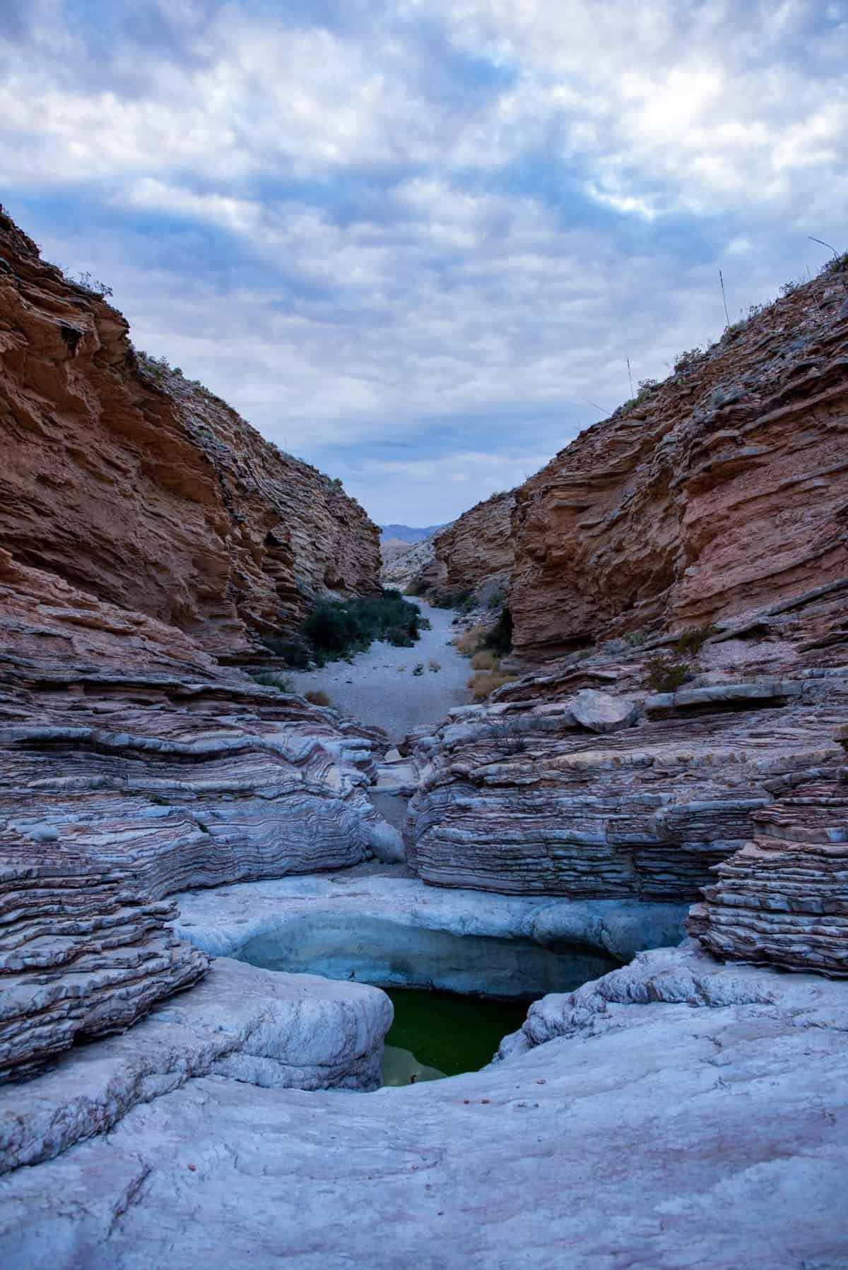
#7: The Ernst Tinaja Trail
Quick Facts on the Ernst Tinaja Trail:
Length: 1.1 miles roundtrip out and back
Rating: Easy
Elevation Gain: 111 feet
Estimated Time to Complete: 30 – 45 minutes

The highlight of the Ernst Tinaja Trail is found after a short walk through a sandy riverbed, then reaching the canyon of rock layers containing the namesake “tinaja”. This large natural rock basin holds water year round. It is a local watering hole for native wildlife, but be careful not to get too close and fall in!
Note that the Ernst Tinaja Trailhead is located on a VERY ROUGH primitive road about 5 miles in length, and it is highly recommended to use a high clearance and/or 4WD vehicle to reach the trail.

#8: Mule Ears Spring Trail
Quick Facts on the Mule Ears Spring Trail:
Length: 3.9 miles roundtrip out and back
Rating: Moderate
Elevation Gain: 410 feet
Estimated Time to Complete: 1.5 – 2 hours

The Mule Ear Springs Trail is one of the most quirky and recognizable hikes in Big Bend. Just look for the two peaks erupting from the desert to form what look like rocky and natural “mules ears” on the horizon. While the mule ears are what this trail is known for primarily, don’t forget about the small, humble spring that is a much needed water source to native vegetation and animals. This is overall a beautiful canyon hike with fantastic expansive views in all directions!
#9: Balanced Rock (via the Grapevine Hills Trail)
Quick Facts on the Balanced Rock Trail:
Length: 2 miles roundtrip out and back
Rating: Moderate
Elevation Gain: 246 feet
Estimated Time to Complete: 45 – 60 minutes

Balanced Rock via the Grapevine Hills Trail is a great option for a shorter, relatively easy, day hike in Big Bend. As far as destination hikes go, this one has a pretty classic destination at its halfway or “turnaround” point.
The trail starts in a gravel ravine, with mild but consistent elevation gain. Most of the gain comes in the last quarter mile before reaching the cluster of balancing rocks. There are some boulders to navigate on this final part of the trail with some scrambling, as well as some spots with loose rock. Be extra careful of foot placement on this final push to the balancing rocks, and follow the directional signs through the scramble portion.
Also note that the road into the trailhead is fairly rough, and high clearance and 4WD, though not necessary, is helpful. There is also limited parking at the trailhead with about 10 spots.

#10: Big Bend Hot Springs Trail
Quick Facts on the Big Bend Hot Springs Trail:
Length: 1.2 miles roundtrip loop
Rating: Easy
Elevation Gain: 144 feet
Estimated Time to Complete: 30 – 45 minutes

This is a both a very scenic and historic trail, with the famous Langford Hot Springs as a landmark. The trail starts off paralleling the Rio Grande River, and just a short ways in actually arrives at the historic Langford Hot Springs. What used to be J.O. Lanford’s hot springs resort, which even had the ability to house overnight guests, is now just the natural hot springs contained by the remaining remnants of the foundations. It is still a favorite spot to relax in Big Bend National Park, and take in some unrivaled scenery while enjoying a soak in these naturally heated springs. There are also ancient pictographs on display near the hot springs for viewing.
After your time at the hot springs, you can simply retrace your steps back to the trailhead, passing once again by the Rio Grande River, or continue on the loop trail to finish the entire hike.
Recommended Gear for the Best Hikes in Big Bend National Park
With the rugged terrain of this region, you will want to invest in a couple key pieces of gear to help you have the most responsible, safe, and comfortable experience on these best hikes in Big Bend National Park!
Recommended Gear Quick Links:
- HOKA One One Speedgoat Trail Runners
- Vasque Breeze GTX III Hiking Boots
- Hilly Twin Skin Socks
- Camelbak Helena Daypack
- Osprey Daylite Daypack
- Platypus Hydration Bladder
- Black Diamond Trekking Poles
- Outdoor Research Helium II Jacket
Now let’s take a deeper dive into each of these recommended items of gear, and just why they are so important when exploring these 10 best hikes in Big Bend National Park!
- FOOTWEAR– Big Bend’s trails contain a myriad of terrain and elevations, so it is best to hit the trails with a reliable pair of hiking boots or trail runners. The choice is up to your personal preference, but I personally like to do my Big Bend hiking in trail runners. Trail runners are lighter, so my feet feel “fresher” and quicker after a long day of hiking. Plus trail runners, like my favorite HOKA One One Speedgoats, don’t compromise on cushioning or grip. There is a place for traditional hiking boots too in Big Bend, as the ascents and descents of some of the challenging trails can be better handled with the support of a good hiking boot, like my go to Vasque Breeze GTX III hiking boots. Bonus that they are waterproof as well, which comes in handy for a park that has several large and small waterways!
- PERFORMANCE SOCKS – your footwear is only as good as the socks that you pair them with. Nothing can derail a hike quicker than blisters. I used to be very blister prone, especially on longer hikes, but I haven’t had a single blister since discovering Hilly Twin Skin socks, not even on some of my longest and grueling day hikes, like the Grand Canyon’s Rim to Rim hike, or California’s Mt. Whitney, the highest point in the lower 48 states. The “twin skin” is what helps to prevent the friction that can cause blisters.
- DAYPACK– in a region as wild as Big Bend, any time you take on these trails, you should do so with a daypack capable of carrying whatever water you need, plus all of your 10 hiking essentials. My favorite daypacks are the Camelbak Helena daypack and the Osprey Daylite daypack.
- WATER– make sure to carry enough, in a trusted transportation system. I always hike with at least 3 liters when I hike in Big Bend National Park. I prefer to use this Platypus Hydration Bladder, as it can hold 3 liters, and the wide mouth makes filling, emptying, drying, and cleaning simple. Plus, it gives me easy, quick, and consistent hydration on my toughest hikes.
- TREKKING POLES – there are some serious elevation gains and losses on some of these best hikes in Big Bend National Park, and a good, reliable pair of trekking poles can help give your knees more support for both the uphills and downhills. The most trusted brand trekking poles out there are Black Diamonds. I love this particular model for the cork handles, which help prevent the slippage from sweaty hands that you can encounter on other rubber or plastic handled models.
- LIGHTWEIGHT OUTER SHELL – no matter the season, I like the reassurance of being able to have a fully waterproof and windproof outer shell. The ultra-lightweight Outdoor Research Helium II jacket compresses down to the size of a hand, and literally weighs only an ounce. It is perfect for an outer layer of protection that is fully waterproof and windproof, as well as super easy to pack and carry!
- HIKING SNACKS – this isn’t really a “gear” item technically, but it should be on your list anytime you are hiking. The best hiking snacks can help to keep you safe by providing energy and valuable nutrients during some of your toughest hikes. When you think of hiking snacks, think lightweight, easy to carry, minimal trash, and full of beneficial energy.
*These recommendations above are not meant to be an exhaustive list of all your 10 hiking essentials. You can get a complete CHECKLIST HERE to make sure you don’t forget a single thing!
Personal Recommendations on Hiking in Big Bend National Park
Here’s the answer to some common questions regarding these best trails in Big Bend National Park.
My Personal Favorites:
Santa Elena Canyon – I’ve gotten to hike AND kayak in Santa Elena Canyon. The views are mesmerizing and make you feel truly small.
Emory Peak and Lost Mine Trails – both great mountain hikes with impressive summit views, for a little extra challenge. If you are shorter on time, Lost Mine is a better choice.
The Window Trail – so unique among hikes, that I would highly recommend it as a moderate distance and difficulty hike. I LOVE the way the canyon walls converge, and hiking over the rock stairs and shallow streams and pools. It is its own secret world inside the canyon.
The Best Short, Easy, Family Friendly Hikes:
My vote goes again for Santa Elena Canyon. It can suit the needs of a variety of group members, without sacrificing on views!
My runner up vote goes to the Balanced Rock hike. Again, a short, relatively easy hike, with a cool payoff in the balancing rock formation. Fun to see for all ages!
Most Secluded Hikes on this List:
Some hikers hike to get away from it all, and that is the biggest draw when choosing a trail. Big Bend undoubtedly has some more popular hikes, but then it has some equally more secluded ones, where you will have more of the trail to yourself:
The South Rim Trail – the ruggedness and longer distance discourage the larger crowds
Ernst Tinaja and Mule Ears are also less populated, as they are more “off the beaten path” of traffic and more isolated from some of the more popular attractions in the park.
If You Only Have 1 Day:
What hikes should you do if you only have 1 day?
I would definitely try to do Santa Elena Canyon and the Lost Mine Trail, as they are both shorter, with unforgettable views. Santa Elena Canyon is relatively easy, and the Lost Mine Trail is more challenging while still being short, so you get to experience both ends of the spectrum. It is realistic to hike both of these trails before lunch, if you start early. Plus, with these 2 trails, you can witness several unique characteristics of Big Bend: rivers, canyons, and mountains!
If you have time after lunch, I would hike the Window Trail. It is in close proximity to the Lost Mine Trail. These 3 hikes would be my top choices for a 1 day hiking itinerary in Big Bend National Park.

And there you have it, the 10 best hikes in Big Bend National Park! Looking for other ways to make the most out of a Big Bend visit? Then check out:
- Two Ways to Explore Santa Elena Canyon
- Texas National Parks Roadtrip
- The Top 5 National Parks in the Southwest U.S.
- The Best Southwest National Parks Roadtrip
And don’t forget to grab your own National Parks Checklist so you can check another park off the list!

Other Nearby Attractions in Texas
Big Bend may get most of the attention, but there are actually 2 National Parks in Texas! Don’t miss out on more mountains in Texas, including the highest point in Texas at Guadalupe Peak, in Guadalupe Mountains National Park!
One of the nearest towns to Big Bend National Park is Fort Davis. Find out just what makes this old west town my favorite small town in Texas!


Check out More of My National Park Guides:
- White Sands National Park Guide
- Best Hikes in White Sands National Park
- Guadalupe Mountains National Park
- Guide to the Guadalupe Peak Trail
- Carlsbad Caverns National Park Guide
- Arches National Park 1 Day Itinerary
- Shenandoah National Park 1 Day Itinerary
- Best Hikes in Cuyahoga Valley National Park
- The 8 Best Day Hikes in Grand Teton National Park
- How to Hike Rim to Rim in Grand Canyon National Park
- National Park vs. National Forest
- Guide to the Twin South Dakota National Parks
- The Top 12 National Park Marathons and Half Marathons
- Best 3 Day Yellowstone Itinerary from the West Entrance
PIN for LATER!