Hiking Brasstown Bald Trail: The Highest Point in Georgia
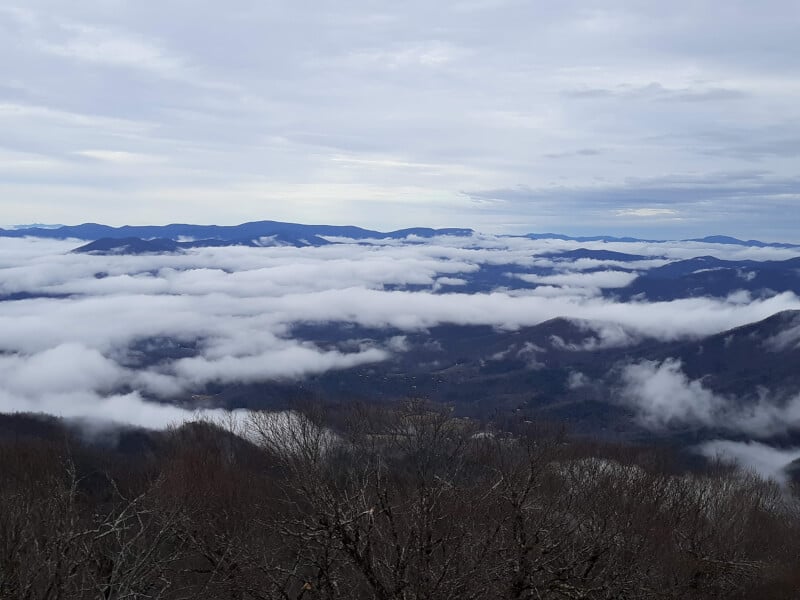
The most ethereal horizons happen when towering mountains clash with the wispy heavens. This is exactly what to expect to see when hiking the Brasstown Bald Trail, the highest point in Georgia. It is one thing to behold the stunning indigo outline of the Appalachians from the ground, but from a vantage point over 4,000 feet up, you can literally see the pillowy clouds of the northern Georgia sky melting into the ridge lines of mountain peaks, creating a one of a kind display that would easily out-compete any museum watercolor. Brasstown Bald is not only the highest peak in Georgia, but arguably one of the most scenic hiking trails in Georgia as well. Nestled in the heart of the Chattahoochee National Forest, this easy day hike to the highest point in Georgia can easily be added on to a full day itinerary for the area, or stand alone as an unforgettably breath-taking high point hike.

Disclosure: Below are some affiliate links-these are all products I highly recommend. I won’t make any recommendations on this page that I haven’t tested or personally used!
Table of Contents
Guide to Hiking Brasstown Bald
I will be the first to admit that I was not expecting the Brasstown Bald Trail to blow me away as much as it did. I encountered this trail to the highest point in Georgia on a winter road trip that took me through six southeastern states, including Louisiana, Alabama, Florida, South Carolina, Georgia, and Mississippi, in my pursuit of hiking all 50 U.S. state high points.
This area of the country is historically known for its less than dramatic elevation gains. So I was stunned at just how much beauty was packed into this 1.2 mile roundtrip hike at the Brasstown Bald Trail. I have stood on the summits of some of the highest and most rugged peaks in the U.S., including Wheeler Peak in New Mexico, Mt. Whitney in California, Mt. Hood in Oregon, and isolated King’s Peak in the far reaches of northern Utah, and Brasstown Bald still manages to rival those in sheer beauty! If you want to know how to experience one of the best mountain views in the country, and one of the best kept secrets of hiking trails in Georgia, keep reading to find out everything you need to know to get the most out of Brasstown Bald!
Location of the Brasstown Bald Trail
Brasstown Bald, the highest point in Georgia, resides in the northern part of the state, in the Chattahoochee National Forest. It is just south of the North Carolina border, near the two small towns of Macedonia and Hiawassee. Brasstown Bald can be accessed off winding mountain Highway 180, which is a scenic view in and of itself to drive.
The Brasstown Bald Trail and the surrounding area
The Brasstown Bald Trailhead is located 0.6 miles below the summit, at the Brasstown Bald Day Use Area. Immediately upon arrival in the parking lot of the Day Use Area, you will be greeted with precursors of the indigo views to be expected at the summit. It will definitely get you excited to get started with the hike! There are several small benches and picnic areas, information bulletins, and restroom facilities in the Day Use Area.

Insider Tip: When I was researching my trip to Brasstown Bald, there were some discrepancies in the description of the actual Brasstown Bald Trailhead. Depending on what you read, it may sound like you have to hike up to the Day Use Area from Highway 180 below, before accessing the actual Brasstown Bald Trail Head. This was not the case for me, I found that you simply drive up to the actual Day Use Area, which contains the 1.2 mile roundtrip trailhead for Brasstown Bald.
The only exception to this I can think is that in the winter, Highway 180 has at times been closed due to weather, south of the Day Use Area and Brasstown Bald, which has caused people to have to park before arriving at the Day Use Area, and having to walk up the road to reach the trailhead.
The official Forest Service website also states the same, noting that the gate leading to the Day Use Area, and the Visitor’s Center and Viewing Platform at Brasstown Bald, will close in unsafe conditions. So if you are planning a visit in the winter months, be sure to check with the Forest Service first.
Quick Facts On the Brasstown Bald Trail
To access the Brasstown Bald Trail, follow Highway 180 north until you reach the Day Use Area of Brasstown Bald. There is a $8 per person fee, and the Day Use Area is open Thursday through Monday between 10am and 5pm.
Because the Brasstown Bald Trail is so steep, there is a shuttle service as an alternative. The $8 fee covers the shuttle service.
There is a water fountain located in the Visitor Center, and toilets located in the Visitor Center and in the Day Use Area near the trailhead.
Length: 0.6 miles out and back (1.2 miles roundtrip) from the trailhead at the Day Use Area to the Visitor’s Center and Viewing Platform on the summit of Brasstown Bald.
Rating: Moderate (due to the steepness of the trail)
What this hike lacks in length, it makes up for in steepness. This summit is one of the highest in the southeast, so in order for it to be such a short, easily accessible summit, it makes sense that it would have to be on the steeper side. However, the trail is largely shaded, as well as entirely paved, so with intentional pacing, the steepness can be overcome by the majority of fitness levels, without any prior training.
Insider Tip: For those potentially worried about the steepness of the trail, there is a shuttle that takes guests from the parking lot at the Day Use Area to the Visitor’s Center and Viewing Platform. Use of this shuttle is included in the $8 per person entry fee.
Elevation: 4,786 feet
Elevation Gain: 423 feet

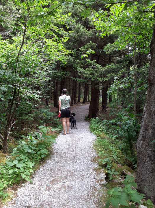
Dog Friendly? Yes, my own pup accompanied my sister and I to the summit, and due to the excellent construction and extremely accessible nature of the viewing platform, it was very easy for her to get around. Dogs are not allowed inside the Visitor Center at the summit, however.
Estimated Time to Hike: 30 minutes
Best Time to Hike: this hike can be enjoyed year round, but Brasstown Bald and the Day Use Area do close for the winter, which means you would have to park before the entrance and hike up much longer to reach the summit. The better alternative is to visit in the Spring, Summer, or Fall.
Gear for Hiking the Highest Point in Georgia
- At least one bottle’s worth of water per person should be easily enough for this hike. There are water fountains at the Visitor’s Center on the summit also. I used this simple and effective hydration waistbelt to transport my water bottle. Plus the pocket is just large enough to carry personal items like your cell phone, keys, credit cards, etc.
- Due to the steepness of the ascent, I would not attempt to hike the Brasstown Bald Trail in shoes like flip flops! A good cushioned trail runner like these HOKA One One Speedgoats are perfect!
- Bring a camera, you will regret it if you do not!
- Bring $8 per person to pay the entrance fee.
- If you plan to take on some other short day hikes in the area in addition to the Brasstown Bald Trail, I recommend a day pack like my favorite Osprey Daylite Day Pack. It is the perfect vessel to carry all of your day hiking essentials.
***Grab your own Day Hiking Essentials Checklist HERE!
Trail Report: Hiking the Brasstown Bald Trail
The Brasstown Bald Trail can be accessed by the trailhead, which is to the right and behind the bathroom facilities at the Day Use Area. The trailhead is not immediately noticeable from the parking lot, but it is hard to miss once you walk closer to and towards the back side of the Day Use Area restroom facilities and informational bulletin boards.

The entirety of this 1.2 mile roundtrip path is paved, making it among one of the more accessible summit high point hikes. At the onset, this trail is heavily shaded by local flora and fauna of the southeast, such as lush, native, Rhododendron, and for a minute you will forget that you are hiking a mountain trail.

Instead, it feels like being transported to an exotic, foliaged tunnel! Surrounded by the thickets and gnarled branches of this southern state really highlight what it is like to experience the highest of hiking trails in Georgia. For those paying close attention, you will begin to notice how the thriving flora at the base of Brasstown Bald slowly and consistently becomes smaller as you climb, fitting with the increasingly higher elevation. It is a subtle educational lesson for those who take the time to notice!

This trend continues until just below the summit, at which point hikers will cross the road that the shuttle bus utilizes to take visitors to the top, and then suddenly the foliage breaks and opens up to the dramatic panorama of the viewing platform and the stark peaks and valleys of the Appalachian Mountains!

the Summit of the Highest Point in Georgia
Brasstown Bald has done an excellent job of celebrating the uniqueness of its high point crown. Great lengths have gone into making this a very enjoyable summit, one in which takes full advantage of the stunning 360 degree views. Those hiking to the summit can expect to be greeted with a enormous circular viewing platform at the summit, with placards marking the directions of the compass so that viewers can determine in which direction they should look out towards neighboring states.
Not only can guests gaze at the horizon towards Tennessee and the Carolinas, but views also include other notable peaks in the area, including Rabun Bald, the second highest peak in Georgia, and Blood Mountain, an iconic peak on the Appalachian Trail, both enshrouded in heavy clouds around their summits.
The Visitor’s Center at the top is among one of the most accommodating around, containing an exhibit area, museum, restrooms, and water fountains, among the several observation decks situated along the viewing platform. Guests are also able to visit the old wooden Lookout Tower found at the summit.
There is ample room on the expansive platform to accommodate large amounts of guests, so that no one feels cramped or competing for the “best” spot in which to get that iconic picture. The summit is completely wrapped in the Appalachian Mountains, so no matter where you are standing along the circumference of the platform, the views are equally stunning.
The whites of the clouds here are perhaps among the most billowy in the country, melding into some of the bluest blues of any mountains anywhere. As far as summit views go, it is undeniably impressive. If you are hiking this trail, you will want to spend a significant amount of time at the top, probably more time than actually spent hiking on the trail!

Other Nearby Hiking Trails in Georgia
About 0.10 miles into the Brasstown Bald Trail, visitors will pass the Wagon Train Trail on the right, a lengthy path that extends further north of Brasstown Bald, passing more stunning mountain peaks of the Appalachians. It is a worthy option for those looking for a little longer of a hiking challenge, and for those wanting to extend their time exploring other hiking trails in Georgia. If you are interested in the Wagon Train Trail, it is a 13.1 mile, out and back trail that climbs 2,844 feet in elevation.
Just south of the Brasstown Bald Trail Head in the Brasstown Bald Day Use Area are two other trail heads, one for the Arkaquah Trail, and the other for Jacks Knob Trail.
The Arkaquah Trail is another one of the more challenging hiking trails in Georgia, whose trail head can be picked up from the Brasstown Bald Day Use Area. It is an 11 mile long out and back trail that gains 3,763 feet in elevation over its course.
Jacks Knob Trail is 8.3 miles out and back, climbing just over 3,000 feet in elevation gain. The trail for Jacks Knob can be found just south of the Brasstown Bald Day Use Area in the parking lot area, or, on the other end, on the Appalachian Trail south of Brasstown Bald in the Mark Trail Wilderness area.
Other Southeastern High Point Hikes
I enjoy hikes of any kind, as it consistently allows me to become exposed to a new perspective and a new challenge, but there is always something unique about hiking to the highest point in a state. Hiking to the highest point in Georgia was no exception! For those who have “checklist” mentalities, it is also a fun way to make it through more un-visited states in a very unique manner!
The Brasstown Bald Trail is among one of my favorite high point hikes in the country, as I close in on summiting all 50 U.S. state high points, and among my other notable southeastern high point hikes that are worthy of a nod are Mount Magazine in Mount Magazine State Park, Arkansas, and Cheaha Mountain, in Cheaha Mountain State Park Alabama!
Curious about the Other State High Points in the U.S.?
Get your FREE 50 State High Points Info Graphic and learn about each and every one of them!
PIN for LATER!


Very nice well written article.