The Driskill Mountain Trail: the Highest Point in Louisiana
There is more to Louisiana than swamps, bayous, and Bourbon Street! Not far from Shreveport lies the highest point in Louisiana, the Driskill Mountain Trail! Though not known for its towering peaks, this southern state manages to surprise with this charming highpoint! This trail balances accessibility with just enough surprising challenge, variety, and scenery, making this a highpointing experience well worth pursuing!

Disclosure: Below are some affiliate links-these are all products I highly recommend. I won’t make any recommendations on this page that I haven’t tested or personally used!
Table of Contents
Guide to the Driskill Mountain Trail – the Highest Point in Louisiana!
This guide to Driskill Mountain Louisiana will cover the location and a full trail report for planning purposes.
Location of the Highest Point in Louisiana
The Driskill Mountain Trail is located approximately one hour east of Shreveport, Louisiana. It can be accessed off of Interstate 20 East, south of the small town of Arcadia, Louisiana, on Highway 507. The parking area and trailhead for Driskill Mountain are located adjacent to Mount Zion Presbyterian Church, on the left side of the church building. There is a cemetery immediately behind the church, and a small brown sign on the lawn in front of the church labeled “Driskill Mountain, elev. 535 feet”. This trail and state high point does lie within private property.
Driskill Mountain Louisiana and surrounding area
Quick Facts on the Driskill Mountain Trail
Length: 1.5 miles out and back roundtrip
Elevation: 535 feet
Elevation Gain: 167 feet

Rating: Easy – this trail is well marked, short, shady, and with minimal elevation grade.
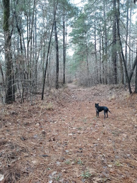
Dog Friendly: Yes, our pittie Middy joined us on this trail. She loved the soft underfooting of the path and the shade, and enjoyed climbing and jumping over some of the fallen trees that she found along the way!
Fees: Driskill Mountain is free to hike
Estimated Time to Hike: 45 – 60 minutes
Best Time of Year to Visit: Driskill Mountain Louisiana is open year round, and is hikeable in any season

Driskill Mountain Trail Report
I visited Driskill Mountain on the first stop of a highpointing road trip that took me to the tops of six southern state highpoints, including Louisiana, Florida, Alabama, Georgia, South Carolina, and Mississippi. I had the pleasure of visiting this highpoint on New Years Eve with my husband, as we decided we wanted to explore the backcountry of this state in peaceful seclusion, as opposed to more chaotic ways of ringing in the new year!
This was the perfect spot and the perfect way to close out one year and ring in another, by hiking to the highest point in Louisiana. This hike is just long enough, with just enough elevation gain, to make it a fun way to get some exercise on a short day hike, with plenty of energy left over to last you the rest of your day, whether your plans include trying to stay up until midnight or not!
Insider Tip: Most likely, you will have this trail to yourself and highpoint without crowds. But there are signs warning to be aware and pay attention during hunting season.
The Trailhead of the Driskill Mountain Trail
This highpoint hike has a unique start at the trailhead. The trailhead is located just to the left of the church and church parking lot. You can park in the parking lot on the left hand side of the church. There is no cost.

There are small signs marking the trailhead of the Driskill Mountain Trail, which looks more like a dirt service road at the beginning. There is a metal gate to go around at the very beginning. The main trail follows what almost has a ravine type of feel to it, with slopes on either side gently easing down to meet in the middle, the trail. It is cleared out, well maintained, and well marked.
There is plenty of shade on this hike to the highest point in Louisiana, as the majority of it occurs under heavy tree coverage. This can make the underfooting of the trail a bit on the soft side, even a little soggy, as there is not a lot of natural sunlight reaching the bottom to dry out any precipitation. Except a decent layer of needles and fallen leaves on the ground.
My husband and I happened to hike this trail shortly after a rain, and it was almost a necessity that we had hiking footwear just to wade through some of the larger sections of muck. Though on a dryer day, I would recommend just a regular trail shoe.
Heading in from the trailhead, the path is very easy to follow. The trail is wide, with trees shouldering on either side. As I mentioned before, the trail in is very soft, and there are no real rocky or uneven sections. The trail is flat with very minimal grade.
Summiting the Highest Point in Louisiana
There are actually two different ways to hike up to the highest point in Louisiana and back on Driskill Mountain. I am going to recommend taking one route in and one back, as I did, in order to experience a little more variety and see both sides of this mountain. I am curious to see which trail you prefer, as I definitely had my favorite. To follow my same itinerary, plan to hike the Driskill Mountain Trail in to the summit, and return via the False Mountain Trail.

About ten minutes past the beginning of the Driskill Mountain trailhead, hikers will pass a split on the right hand side for the False Mountain Trail. This does lead to the summit atop the highest point in Louisiana. It is slightly more steep than the Driskill Mountain Trail. We opted to continue on the main trail to the summit, and return down via the False Mountain Trail, so we experienced the grade going downhill. But it is completely doable to hike this summit in reverse of the way I did, going up the False Mountain Trail to the summit, and returning down the main Driskill Mountain Trail.
Continuing on past the split for the False Mountain Trail, the main path steers straight ahead until reaching the ascent up to the summit.

Insider Tip: You can continue on the main trail past the signage for the ascent up to the summit, however, we tried this route out and did not find it worthwhile as an add on. The main path continues on only a short distance, before running into an empty field that resembles some type of previous maintenance or industrial site. We stopped here and turned around, but eventually this trail would dead end onto a rural country road.

There is a very short, consistent grade up the ascent to the top of Driskill Mountain. The summit contains a few benches and a wooden placard labeled “Driskill Mountain”, with a registry to record your visit to the highest point in Louisiana. The overlook is named the “Jordan Mountain Overlook”. There are views, but only on one section of the summit, the overlook, where the trees open up and there is a gap in the forest for observing the surrounding hills. This is a very quiet and undisturbed summit, and it is quite peaceful to stop and spend a few minutes resting at the top.
For the descent, I encourage hikers to depart down the False Mountain trail, which leads away from the summit towards the right side of the wooden placard, marked with blue blazes consistently on the trees. This False Mountain trail departing the summit has a more natural path feel to it, and less like the “forest service road” feel found in some spots on the main trail in. This trail is much narrower, but still easy to follow.
There are a few slightly uneven sections along the False Mountain path, and the surrounding trees definitely feel like they close in on you more here, however, nothing too challenging. But all this leads to the authenticity of this trail. The False Mountain Trail winds in and out among the trees, down the hill, and even traversing over some fallen logs that lie in the pathway.
The False Mountain Trail will spill back out onto the main Driskill Mountain Trail, at which point hikers will go left to leave back towards the trailhead and parking lot.
This trail definitely does not have the big name boasts of some of the more looming of the 50 state high points in the U.S, like Mt. Whitney in California, or Wheeler Peak in New Mexico, or Mt. Elbert in Colorado’s Rocky Mountains, or Mt. Hood in Oregon, but it still gives visitors the chance to explore a highpoint with multiple trails, scenic views, secluded forests, and a very doable rating! Almost anyone of any fitness level can enjoy a visit to this highpoint, any time of the year!
Read More: Interested in other state highpoint hikes across the country? My home state of Texas has a high desert stunner, the Guadalupe Peak hike! King’s Peak in Utah gives you the chance to backcountry hike and camp before reaching the summit! Brasstown Bald in Georgia has some of the most beautiful smoky views of any high point perspective so far! You can read about more of the high point hikes I have completed and written guides for here.
Ready to Check Off All 50 State High Points?
Get Your FREE High Points Info Graphic here!
RELATED ARTICLES:
- Guide to Hiking Mount Mitchell – the Highest Point in North Carolina
- Guide to Hiking Mt. Magazine -the Highest Point in Arkansas
- Guide to Hiking Clingman’s Dome – the Highest Point in Tennessee
- Guide to Hiking Brasstown Bald – the Highest Point in Georgia
PIN for LATER!