Taum Sauk Mountain State Park: The Highest Point in Missouri
I love it when states take their beloved high point and create a park around it to symbolize its importance to the state. I have seen this occurrence across the country in my pursuit of hiking all 50 U.S. state high points, from Black Elk Peak in South Dakota and its Custer State Park, to Cheaha Mountain in Alabama and its Cheaha Mountain State Park, to Mount Magazine in Arkansas and its Mount Magazine State Park. And now in Taum Sauk, Missouri, at Taum Sauk Mountain State Park. Not only is this a special way to memorialize a hike to the top of the highest point in Missouri, but it gives visitors a chance to create a whole day, or weekend, out of a visit to Taum Sauk Mountain State Park!

Disclosure: Below are some affiliate links-these are all products I highly recommend. I won’t make any recommendations on this page that I haven’t tested or personally used! Enjoy this guide to the highest point in Missouri at Taum Sauk Mountain State Park!
Table of Contents
The Highest Point in Missouri at Taum Sauk Mountain State Park
Taum Sauk Mountain State Park resides in a pocket of Missouri’s Ozarks region, specifically the Saint Francois range. Which essentially means that this park and its resident Taum Sauk Mountain get to similarly borrow from all the majestic beauty found in the neighboring Ozarks. To boot, this state park and its hike to the highest point in Missouri is rather secluded, so you have the chance to not only enjoy Missouri’s forests and woodlands, but to possibly have it all to yourself!
Location of Taum Sauk Mountain State Park
Taum Sauk Mountain State Park is located in southeastern Missouri, nearby the small town of Ironton. It resides nearby to Mark Twain National Forest, and it is only a stone’s throw from the famed Ozarks region.
Map of the Taum Sauk State Park region
the Taum Sauk Mountain Hike
- Length: 0.4 mile out and back roundtrip (what exactly is an “out and back trail”?)
- Elevation: 1,772 feet
- Elevation Gain: 13 feet
- Rating: Easy
- Estimated Time to Complete: 10-15 minutes
- Dog Friendly: Yes, my two pups accompanied me on this trail easily. Dogs must be leashed in Taum Sauk Mountain State Park.
- Best Time of Year to Visit Taum Sauk Mountain: The best time of year is spring and fall. Summer is doable, but can get extremely humid and hot. Winter may come with snow and ice. Taum Sauk Mountain State Park is open year round.
- Fees: it is free to enter Taum Sauk Mountain State Park
- Hours: Taum Sauk Mountain is open daily year round
- Parking: there is plenty of paved parking at the trailhead
Getting to the Highest Point in Missouri
The hike to the top of Taum Sauk Mountain is a pleasant mix of state high point characteristics. By no means is it a grueling trek or boasts unbeatable views, but there is plenty to appreciate by tackling this state high point hike, besides simply the chance to be exposed to the Missouri Ozarks region and these Saint Francois Mountains!
First, the drive up to Taum Sauk Mountain State Park and the Taum Sauk Trailhead is quite enjoyable. I have been to state high points where you simply pull off the road and you have arrived at the state high point, but on a visit to Taum Sauk, visitors get to enjoy a scenic drive through quaint Missouri towns, and winding, shaded two lane roads.
A majority of the ascent up Taum Sauk Mountain is done by vehicle, as you proceed through the initial Saint Francois valley small towns and then up the mountain roads into Taum Sauk Mountain State Park. After entering the park (free of charge), signs will lead you a short ways to the parking area for the Taum Sauk Mountain state high point trail.
Taum Sauk Mountain Trail Report
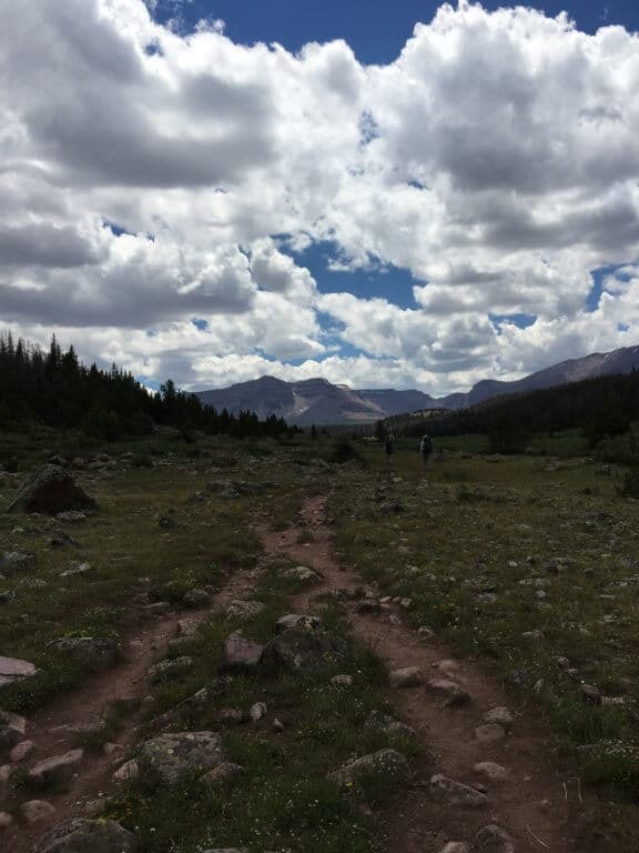
The trail to the state high point at the top of Taum Sauk Mountain is very short, 0.4 miles roundtrip, and paved for a majority of the trek. It is a very user friendly, all age appropriate, ADA accessible, stroller friendly, state high point trail. Because most of the elevation gain is achieved on the drive up the mountain, the trail itself is almost completely flat.
There are plenty of shaded, forest views on Taum Sauk, and the silence and peacefulness is deafeningly stunning. It is definitely something to appreciate, though do not expect there to be a break in the trees for panoramic views. The forest views are consistent throughout the entirety of this hike.
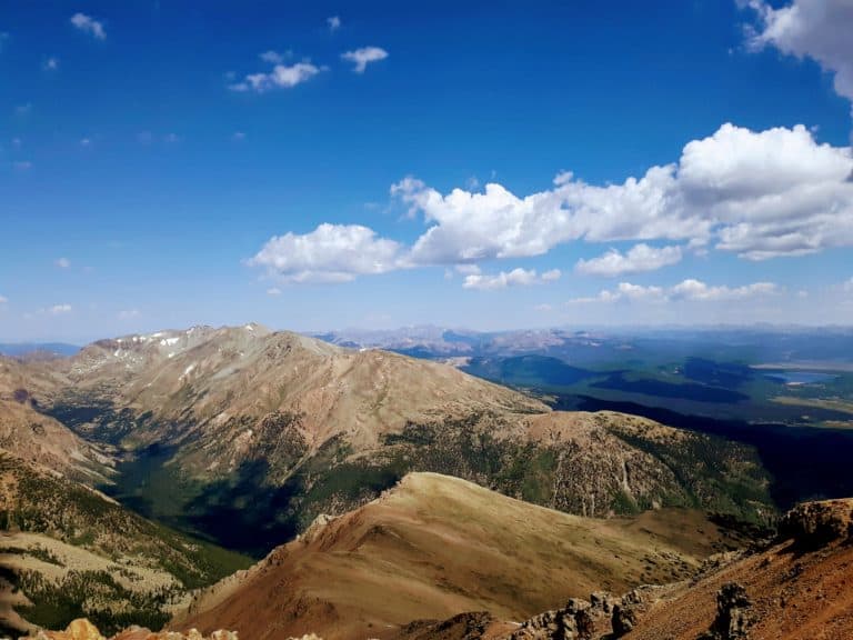
Insider Tip: if you want panoramic views of the surroundings from Taum Sauk Mountain, plan to stop at the scenic overview on the drive in, as you will not be able to access scenic views from the summit itself of Taum Sauk Mountain. There is a viewpoint on the right hand side of the road immediately after entering into the park boundaries.
At the summit of Taum Sauk, there is a simple engraved placard placed at the base of a large boulder, adjacent to a single bench installed by the Highpointers Foundation. Again, though there are no tell tale views signaling the top of Missouri as far as dramatic panoramas, but there is plenty of dappled sunlight, whispering leaves, and waving branches to greet you here, and more than likely you will find this to be a peaceful and un-busy state high point visit.

Sound lilke a little too simple of a hike for you? Luckily, there is a fantastic add on to this state high point hike – the Mina Sauk Falls Trail, the highest waterfall in Missouri at 132 feet! Visitors can find this trail continuing on from the state high point.
Mina Sauk Falls Trail
The Mina Sauk Falls trail is a welcome relief to those that might feel that the state high point hike was not enough to satisfy their hiking itch! Whereas the state high point is flat and somewhat monochromatic as far as views, the Mina Sauk Falls Trail delivers on both of these ends, and that is what makes it my solid and definitive recommendation as an add on to the state high point!
Mina Sauk Falls Trail Facts:
- Length: 2.9 mile roundtrip loop trail
- Elevation Gain: 433 feet

Mina Sauk Falls Trail Elevation Chart
- Rating: Moderate to Hard (due to the extended amount of rocky sections)
- Dog Friendly: Yes

The Mina Sauk Falls trail is what is considered a wet weather specialty. That is because the state’s highest waterfall graces this hike! That’s right, the highest point in Missouri and the highest waterfall in Missouri can be found within a couple miles of each other!
The Mina Sauk Falls are actually the half way point of this loop trail, but I would recommend completing the rest of the trail. If you continue on for the whole loop, you will also notice that the Mina Sauk Falls Trail intersects with the long distance Ozark Trail, which, should you choose to continue down that route, will take you all the way to Johnson Shut Ins State Park.
The Mina Sauk Falls are all the more dramatic during the wettest springtime months in Missouri, or year round if you are lucky enough to visit after a substantial rainfall. It is hard to imagine that just past the state high point this waterfall reward awaits, cascading over a series of rocky ledges into dazzling pools at the base.
Insider Tip: due to the wet and rocky nature of this trail, I would recommend waterproof hiking boots, like these waterproof Vasque Breeze GTX hiking boots, over trail runners, to get the most enjoyment out of this particular path!
Do not be fooled by the simplicity of the hike to the state high point if you are considering continuing on to Mina Sauk Falls! These two neighbors could not be more different. Whereas the state high point trek is paved, Mina Sauk Falls Trail is almost all rocky and uneven! Wear hiking boots, and trekking poles like these Black Diamonds if you are not as confident on uneven terrain. My recommendations for both of these can be found at the end of this post.
Other Hikes at Taum Sauk Mountain State Park
The great thing about this state high point hike is that you can add on to it many of the other fun hikes at Taum Sauk Mountain State Park, or even go camping at one of the 12 basic sites at the Taum Sauk Mountain State Park campground!
If the state high point and the additional Mina Sauk Falls Trail still are not enough, there is the option to press further on until reaching the Devil’s Tollgate, a unique formation hewn from the volcanic rock of the region.
Still need more hiking out of Taum Sauk Mountain State Park? Past the Devil’s Tollgate, the trail turns into a section of the Ozark Trail, and if you continue for 14 more miles, hikers will find themselves in the midst of Johnson’s Shut In State Park, one of Missouri’s most beloved and beautiful state parks!
Insider Tip: Fall is a great time of year to do some extended hiking in this region, as Taum Sauk Mountain State Park and its surroundings boast some vibrant autumn colors, easily rivaling some of the Northeast’s own views!
Recommendations for Hiking The Highest Point in Missouri
If you plan to spend a day, or more here, at the highest point in Missouri, there are a few hiking recommendations I would make:
- bring plenty of water (especially during the summer season when humidity is extremely high) in a suitable water transportation system like the Platypus hydration bladder that I use on all my day hikes
- if you are planning to add on any of the additional hikes, bring the 10 hiking essentials in a suitable daypack, like the Camelbak Helena women’s 20 liter daypack I use for all of my day hikes
***Download your own Day Hiking Essentials Checklist HERE!
- if you plan to enjoy the Mina Sauk Falls Trail, wear a sturdy pair of waterproof hiking boots, like these trusty Vasque Breeze III GTX hiking boots that have carried me to state high point summits across the country!
- due to the rocky terrain of the Mina Sauk Falls Trail, a pair of trekking poles may be beneficial! These are hands down the best trekking poles on the market, with an undeniably solid reputation!
Curious About Your Own State High Point? How ‘Bout All 50 of Them?
Grab your FREE Download of All 50 State High Points in the U. S. HERE
PIN for LATER!