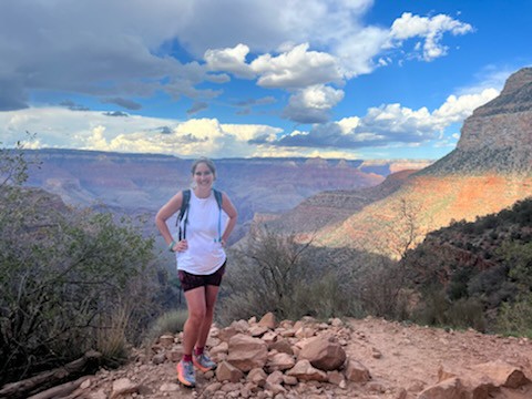
Guide to Hiking the South Kaibab to Bright Angel Trail
Contemplating a hike from the South Kaibab to Bright Angel Trail? If so, you are looking at what is better known as a “Rim to River hike”. And it’s a doozy of a hike, but you’re in the right place! This guide will get you familiar with both of these South Rim corridor trails, including full trail reports, in order to prepare for a full hike of the South Kaibab Trail to Bright Angel Trail!
This guide covers:
- Background on Hiking the South Kaibab to Bright Angel Trail – aka “Rim to River” hike
- Location of the South Kaibab Trail and Bright Angel Trail
- What to Know Before You Go
- Tips for Hiking South Kaibab to Bright Angel
- Why South Kaibab to Bright Angel?
- How to Access the South Kaibab and Bright Angel Trails
- Map of the Rim to River Hike via the South Kaibab Trail and Bright Angel Trail
- Overview of the Rim to River Route via South Kaibab and Bright Angel
- South Kaibab Trail at a Glance
- Bright Angel Trail at a Glance
- Full Trail Report on Hiking the South Kaibab Trail to Bright Angel Trail – aka “Rim to River” hike
- Gear Recommendations for the South Kaibab to Bright Angel Trails
- FAQS
- Recommendations for Hiking Rim to Rim

Disclosure: Below are some affiliate links-these are all products I highly recommend. I won’t make any recommendations on this page that I haven’t tested or personally used! Enjoy this guide to hiking the South Kaibab to Bright Angel Trail!
Table of Contents
Guide to Hiking South Kaibab to Bright Angel
If you have ever wanted to tackle one of the hardest hikes in the country, look no further than the South Kaibab Trail and Bright Angel Trail. Individually, these 2 South Rim trails make up 2 of the 3 inner corridor trails at the Grand Canyon.
What is an inner corridor trail? An inner corridor trail is a trail in Grand Canyon National Park that descends down into the canyon, and meets up with the other inner corridor trails at the bottom, thus connecting the South and North Rims.
There are 3 inner corridor trails in Grand Canyon National Park:
- The South Kaibab Trail – South Rim
- The Bright Angel Trail – South Rim
- The North Kaibab Trail – North Rim

The 3 maps below, courtesy of the NPS, show how these 3 inner corridor trails connect to each other at the bottom of the Grand Canyon, in the vicinity of Phantom Ranch and Bright Angel Campground. There are several popular hiking routes that connect these 3 inner corridor trails in various ways, or you can hike them individually roundtrip.
*If you are considering hiking either the South Kaibab Trail or Bright Angel Trail individually (down and up the same trail), be sure to check out this guide to the South Kaibab Trail vs the Bright Angel Trail to help you make your choice as to which individual South Rim corridor trail you will hike!


Two of the most popular ways to hike the inner corridor trails at the Grand Canyon are a Rim to River hike, and a Rim to Rim hike.
A Rim to Rim hike is a trek from one rim to the other, either North to South or South to North. The most popular route (and the one I highly recommend for first time Rim to Rim hikers) is from the North Rim to the South Rim, via the North Kaibab Trail to the Bright Angel Trail.
It is possible to hike a Rim to Rim going South to North, but my guide on the Rim to Rim hike goes into detail about why this isn’t the recommended route. It is also not recommended to finish a Rim to Rim hike by ascending the South Kaibab Trail, because there is no water on this trail. That is why a Rim to Rim hike that finishes on the South Rim is recommended to ascend the Bright Angel Trail. I will get into more details about the pros and cons of both the South Kaibab Trail and Bright Angel Trail later.
The 24 mile long Rim to Rim hike is rightfully billed as one of the toughest hikes in the country, if not the world, and for good reason. Which brings us to the other popular inner corridor combo: the Rim to River hike!

The Rim to River hike is the little sibling of the Rim to Rim hike, and possesses its own endearing qualities. As a stand alone hike, it is an outstanding Grand Canyon hiking experience, and arguably easier to pull off logistically than a full Rim to Rim. A Rim to River hike is also a great practice run for a full Rim to Rim hike, or simply an alternative for those not pursuing a full Rim to Rim hike. A standard Rim to River hike descends and ascends the South Rim, using the South Kaibab Trail and Bright Angel Trail.
While there are multiple ways to hike a Rim to River (descend and ascend the North Kaibab Trail – not recommended due to 28 mile roundtrip distance), (descend and ascend the same South Rim trail – down and up Bright Angel only, down and up South Kaibab only), (down Bright Angel and up South Kaibab), the most highly recommended and popular route remains descending South Kaibab and ascending Bright Angel.
Why? The main factor driving the directional preference of a Rim to River hike (and a Rim to Rim hike as well), is the fact that there is NO WATER on the South Kaibab Trail. Hiking down into the canyon and back up is arduous and long, no matter how you attack it. I would never recommend hiking up a steep, exposed trail, that can get quite hot to boot, at the end of a long day when you are already depleted enough, without water availability! This is why you will see all inner corridor trail combos primarily avoid hiking up the South Kaibab Trail.
So now you know the background on common corridor trail combos. This post will focus on the standard and recommended Rim to River hike, utilizing the South Kaibab Trail to Bright Angel Trail.
Location of the South Kaibab Trail and Bright Angel Trail
Both the South Kaibab Trail and Bright Angel Trail are located on the South Rim of Grand Canyon National Park. They are located about 4 miles apart from each other, or about 10 minutes drive time.
Locations of the South Kaibab and Bright Angel Trails
Closest Town(s) to the South Rim:
- Tusayan, AZ: 15 minutes
- Williams, AZ: 1 hour
- Flagstaff, AZ: 1 hour and 30 minutes
Closest Airport(s) to the South Rim:
- Grand Canyon National Park Airport (Tusayan): 15 minutes
- Flagstaff Pulliam: 1 hour and 30 minutes
- Phoenix Sky Harbor International Airport: 3 hours and 30 minutes
What to Know Before You Go
Grand Canyon National Park Hours: the South Rim is open daily, 24 hours a day (the North Rim is closed during the winter months)
Grand Canyon National Park Entrance Fees: $35 per vehicle good for 7 consecutive days
Best Time to Hike the South Kaibab to Bright Angel Trails: late spring or early fall
Permits/Reservations: there are NO permits or reservations required to day hike from South Kaibab to Bright Angel. Permits/reservations are only required if you are camping in one of the campgrounds along the way (Bright Angel Campground or Phantom Ranch at the bottom / Havasupai Garden Campground on the Bright Angel Trail). Note that Phantom Ranch reservations are made via a lottery system.
Pet Policy: pets are NOT allowed on either the South Kaibab or Bright Angel Trails
Tips for Hiking South Kaibab to Bright Angel
- Descend the South Kaibab Trail and ascend the Bright Angel Trail
- Check the free park shuttle schedule for drop off times at the South Kaibab Trail (cannot park at the trailhead)
- Book lodging as far in advance as possible
- Bring all necessary hiking gear for Grand Canyon trails
- Bring PLENTY of water in a reliable water transportation system!
- Bring a backup filtration system in case of emergencies
- Bring plenty of healthy hiking snacks and foods
- Wear the right layers (moisture wicking, breathable, UV protection, etc – avoid black!)
- Bring reliable trekking poles if preferred
- Check the NPS website for alerts/updates before hiking (occasionally water is off along trails in the canyon or there are other closures/updates that could affect your hike)
- Check the weather before hiking (watch for excessive summer heat, or ice and snow in the peak seasons and winter)
- Be mindful of the heat (the inner canyon temperatures can skyrocket into the triple digits from late spring through fall)
- Know your abilities and be prepared physically
- Be familiar with both trails in detail
- Train rigorously in advance (do not attempt to “just wing it” when hiking a Rim to River)
- Practice similar hiking before the Rim to River (practice hike with the same daypack, hiking snacks, etc. that you plan to use on the Rim to River hike)
- Practice beforehand on trails with similar elevation gain and distance if possible
- Leave the pets at home!
- Start early! You may need all the daylight hours, so start by 6 am at the latest!
- Never enter the Colorado River!
- Stay on designated trails at all times!
- Pack it in, pack it out, and leave no trace
- Respect and do not approach or feed wildlife
Why South Kaibab to Bright Angel?
This question inevitably comes up anytime I talk about a Rim to River hike. Why the South Kaibab Trail to Bright Angel Trail, and not the other way around. For the most part, the answer is due to water availability.
There is no water on the South Kaibab Trail. For that very important reason, it is not recommended to ascend the South Kaibab Trail at the end of a very long day of hiking a full Rim to River hike. Not only are you physically more depleted and in need of hydration, but the South Kaibab Trail is exposed, and temperatures can get hot throughout a large portion of the year. There’s no reason to risk it, especially when there are great alternatives.
By hiking a Rim to River from the South Kaibab Trail to Bright Angel Trail, you essentially get the best of both worlds, and also simultaneously avoid the “worst” of these trails – no water on South Kaibab. Lucky for you, each of these two South Rim trails have their own unique characteristics, which you will get to experience when you hike a Rim to River hike from the South Kaibab Trail to Bright Angel Trail.
This graphic shows a quick overview of hiking the South Kaibab Trail to Bright Angel Trail.

How to Access the South Kaibab and Bright Angel Trails
The most logistically challenging part of a Rim to River hike is accessing the South Kaibab Trail. But rest assured, it’s still relatively not that challenging. Just a few important things to be aware of.
You cannot park or leave a vehicle at the South Kaibab Trailhead. You can only access the South Kaibab Trail by the free park shuttle (orange line), or by being dropped off (by taxi, family, friend, etc). Therefore, it is important to get familiar with the park shuttle’s schedule, as departures run only at certain times of the day, and fluctuate from season to season. The shuttle picks up from multiple spots in Grand Canyon Village.

The good thing is that there is plenty of parking available at the Bright Angel Trailhead. For the purposes of hiking Rim to River, you will want to park your car near the Bright Angel Trailhead, depart from there to the South Kaibab Trailhead either via the park shuttle service or a personally arranged drop off, and then return to your parked vehicle when you finish the Rim to River hike on the Bright Angel Trailhead.

It actually works out that the most logistical planning involves starting the hike, as nobody really wants to deal with extra logistics at the end of a long Rim to River hike. As soon as you finish, you can hop in your waiting car, only minutes from the Bright Angel Trailhead, and get to whatever sounds good to you – food, shower, bed, etc! There’s also plenty of those amenities only feet from the Bright Angel Trailhead, for those that want to immediately relax after finishing the hike.
Map of the Rim to River Hike via the South Kaibab to Bright Angel Trails
The standard Rim to River route via South Kaibab to Bright Angel
Overview of the Rim to River Hike via South Kaibab to Bright Angel
- Length: 16.5 miles roundtrip point to point
- Rating: Very Difficult
- Elevation Gain: 4,747 feet
- Estimated Time to Complete: 8 – 14 hours

South Kaibab Trail at a Glance

Bright Angel Trail at a Glance

Full Trail Report on Hiking Rim to River via South Kaibab to Bright Angel
MILE 0: South Kaibab Trailhead
I recommend a 5 or 6 AM start. Depending on the time of year, you will have around 12 or 13 hours of daylight, and you may need all of them to complete a Rim to River hike. This is also a good time to recommend hiking with a fully charged and reliable headlamp, which is important for pre-dawn starts, or for hikes that run late past dusk.
After arriving at the South Kaibab Trailhead, either via the orange line on the park shuttle, or by arranged drop off, be sure to take advantage of the bathroom and water fill station before starting your descent. Expect a possible line for both.
MILE 0.9: Ooh Aah Point
The first of several stunning viewpoints along the South Kaibab Trail. There are no facilities here.
MILE 1.5: Cedar Ridge
Another beautiful panorama! There is a bathroom here.

MILE 3: Skeleton Point
More epic scenery from yet another South Kaibab viewpoint! You also can catch your first glimpses of the Colorado River below. You should be making good time on your descent down South Kaibab, and while you want to take advantage of that, make sure to pause for a moment and appreciate the beauty! There are a series of steeper switchbacks following Skeleton Point. There are no facilities at Skeleton Point.
MILE 4.4: The Tip Off
The Tip Off is basically the last “landmark” before reaching the bottom. It is located at the junction with the Tonto Trail (which runs east – west). Proceed straight to stay on the South Kaibab Trail and continue the last part of the descent towards the Colorado River and the black suspension bridge.
MILE 7: Bright Angel Campground
After finishing the last portion of the descent and more switchbacks, the final step before crossing the Colorado is proceeding through the tunnel and then reaching the black suspension bridge. After crossing the bridge, you will arrive shortly at Bright Angel Campground, a surprisingly lush oasis at the bottom of the Grand Canyon. If you want, you can hike a few tenths of a mile more to visit Phantom Ranch.
While at Bright Angel Campground, be sure to rest and refuel. I like to actually eat a meal here, like a sandwich, while resting in the shade of the trees along Bright Angel Creek in the campground. I also recommend grabbing a cup of cold lemonade from the canteen (be sure to bring cash), as well as soaking your feet in the cold creek for a refresher. I always bring two pairs of my favorite anti blister socks, and at this point, after soaking my feet, I’ll swap out my dusty pair for a clean pair. It is an amazing morale boost!

Next, get ready for the hardest part of the hike, the ascent up Bright Angel and the South Rim wall! It is 9.5 miles from Bright Angel Campground to the Bright Angel Trailhead.
To access the junction for the Bright Angel Trail, this time you will leave Bright Angel Campground and cross a second suspension bridge, the silver bridge! After crossing the silver bridge, you will reach the south side of the Colorado River on the South Rim, and come to the trail marker for the South Kaibab and Bright Angel Trails. Proceed to the RIGHT to take the Bright Angel Trail.
The trail initially parallels the Colorado River through some sections of sand, before delving once again back into the canyon.


MILE 8.8: River Resthouse
After the trail departs the shoreline of the river and heads back into the heart of the canyon walls, you will reach River Resthouse, which is also adjacent to Pipe Creek Beach. This is not your typical beach, and no matter if you see others attempting to wade into the Colorado River here, resist the temptation. There is a bathroom here, but no water.
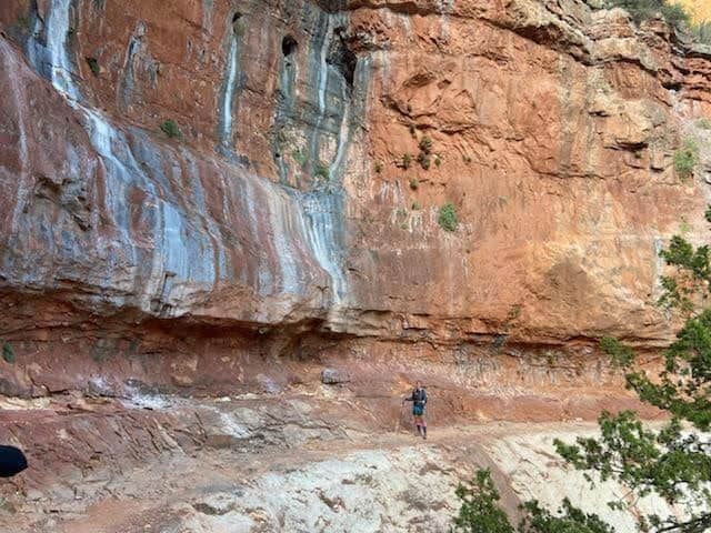
There are just over 3 miles more before reaching the next landmark, Havasupai Garden Campground. In between River Resthouse and Havasupai Garden, however, is one of the hardest sections of a Rim to River hike: the Devil’s Corkscrew. This is a steep portion of switchbacks that climbs an exposed section of canyon, and temperatures may likely be rising at this point in the hike as well. It is important to monitor yourself, take breaks as necessary, hydrate consistently, and replenish electrolytes. I personally like to wear a cotton shirt that I can dip in the multiple streams and little inlets, which works perfectly to hold in the cool and lower my core temperatures. Because the Grand Canyon contains very little humidity, the coolness doesn’t evaporate as quickly. You can also utilize a cooling towel around your neck or head as well.


MILE 12: Havasupai Garden Campground
Much like the oasis at Bright Angel Campground, Havasupai Garden Campground is another surprisingly verdant and welcoming spot along this arid canyon trail. There are bathrooms and water fill stations here, and it is the perfect place to stop for a short break before taking on the final climb out.
There is a brief portion of relative flat after leaving Havasupai Garden Campground, but it does not last for long. Soon you will reach the final series of switchbacks that climb up the South Rim wall, often referred to as “Jacob’s Ladder”, as well as the two remaining Resthouses on the Bright Angel Trail: 3 Mile Resthouse and 1.5 Mile Resthouse.


MILE 13.5: 3 Mile Resthouse
There are bathrooms and water fill stations here. Only 3 miles left, but they are really tough miles. This will likely be the slowest pace of the hike between all of South Kaibab to Bright Angel.

MILE 15: 1.5 Mile Resthouse
The last landmark and break spot before emerging on the top of the South Rim! Again, there are bathrooms and water fill stations here.
As you make your way up this last mile and a half, you will know you are getting close when you pass through the rock tunnel, and then begin to hear the sound of visitor voices along the top of the rim. You may also begin to make out the outlines of the buildings along the rim, as well as notice an uptick in the amount of hikers. Many day hikers hike down Bright Angel to turnaround spots like the Resthouses or Havasupai Garden, and then return for a shorter hike. So this portion of Bright Angel just below the rim tends to get busier with those shorter day hikers, Rim to River finishers, as well as Rim to Rim finishers! You will be exhausted no doubt, but the morale starts to build among those finishing hikers.


MILE 16.5: Bright Angel Trailhead
And you are finished! Luckily, whether you are staying at the South Rim following your completion, or heading to your final destination, everything you need is right there just feet from the trailhead. Your parked car is only a short walk, and for those staying on the South Rim longer, there are multiple places to lodge and eat within minutes of the trailhead. You can immediately refuel, rest, shower, celebrate, and recover!


Gear Recommendations for Hiking the South Kaibab to Bright Angel Trail
While the Grand Canyon may seem incredibly accessible as its facade is flashed across social media, corridor trails are deceptively beautiful. You should never underestimate this National Park, but especially when hiking down into the canyon. People die every single year in the Grand Canyon, and many of those deaths are due to a lack of preparation. It is crucial that you are prepared with the right gear.

Recommendations for Hiking a Full Rim to Rim
If you love the Rim to River hike so much that you decide to take on a full Rim to Rim hike next, check out this first timers guide to hiking the Rim to Rim in one day. In addition, make sure to check out my step by step Rim to Rim training plan, and complete Rim to Rim packing checklist.

Looking at hiking the epic Rim to Rim hike?
How Much Would 4 Months of Accountability and Coaching Mean to You?
Did you know that I offer 1:1 Coaching for the Rim to Rim hike?
Take a look, and COMPLETE THIS INTEREST FORM to get started today!

RELATED ARTICLES:
- Hiking the Widforss Trail on the North Rim of the Grand Canyon
- South Kaibab VS Bright Angel Trail
- Essential Hiking Gear for Grand Canyon Trails
- The Best Healthy Hiking Snacks
- Hiking the North Kaibab Trail to Bright Angel Trail
- First Timers Guide to Hiking the Rim to Rim in One Day
- Complete Rim to Rim Packing Checklist
- Step by Step Rim to Rim Training Plan
- 6 Hiking Exercises You Can Do No Matter Where You Live
PIN for LATER!