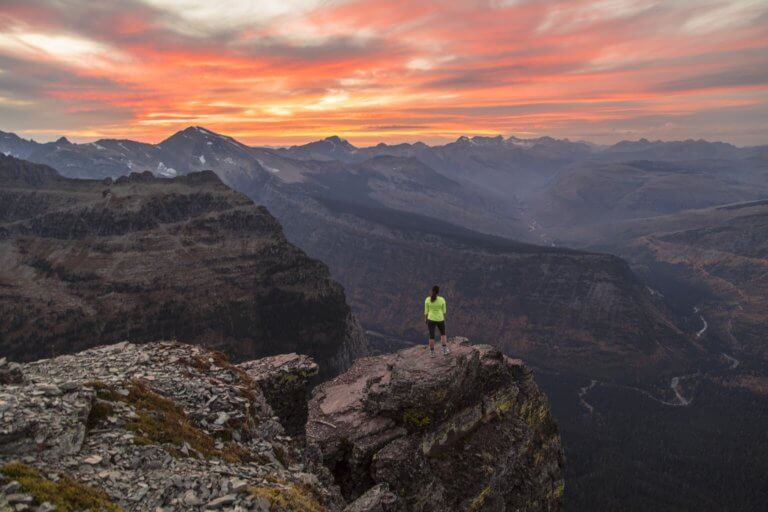
12 Best Hikes in Grand Canyon National Park
We as a society do not realize how lucky we are to have the chance to hike in one of the natural wonders of the world! Exploring this National Park gem by foot is an unforgettable memory! I have been lucky enough to explore nearly every inch of the Grand Canyon’s twin rims, the South Rim and the North Rim, as well as their respective trails. Blood, sweat, tears, and muscle aches have gone into many of these experiences, but that is what makes the Grand Canyon so memorable. Grand Canyon trails include family friendly hikes as well as some of the toughest hikes in the country, but the payoffs are equally some of the best in the world! What makes Grand Canyon hiking so exhilarating is you can customize a hiking itinerary that includes rim views, river views, forest views, or challenging inner canyon views. Get ready for a kaleidoscope of things to see and trails to experience on these 12 best hikes in Grand Canyon National Park!

Disclosure: Below are some affiliate links-these are all products I highly recommend. I won’t make any recommendations on this page that I haven’t tested or personally used! Enjoy this guide to the 12 best hikes in Grand Canyon National Park!
Table of Contents
12 Best Hikes in Grand Canyon National Park
Whether you are an experienced hiker looking for a challenge, or a family looking to experience the outdoors together, there is a trail for every type of adventurer in Grand Canyon National Park. This list of the 12 best hikes in Grand Canyon National Park includes all ratings, including easy, moderate, and difficult, as well as varying distances and highlights to see.

Know Before You Go
LOCATION: Grand Canyon National Park is located in northern Arizona. There are 3 rim areas in the park: the North Rim, South Rim, and West Rim. The South Rim is the most visited area.
HOURS: The South Rim is open daily year round. The North Rim is closed in the winter between mid – October through mid – May.
ENTRANCE FEES: $35 per vehicle (good for 7 consecutive days)
PET POLICY: pets are only allowed on a select few trails in Grand Canyon National Park (see full pet policy here)
DISTANCE BETWEEN THE NORTH RIM AND SOUTH RIM: approximately 4.5 – 5 hours driving
CLOSEST TOWN(S) TO THE SOUTH RIM: Tusayan, Williams, and Flagstaff
CLOSEST TOWNS TO THE NORTH RIM: Jacob Lake, Fredonia, and Kanab, UT
CLOSEST AIRPORT(S) TO GRAND CANYON NATIONAL PARK: Grand Canyon National Park Airport, Flagstaff Pulliam Airport, St. George Regional Airport (UT), and Phoenix Sky Harbor International Airport
PERMITS / RESERVATIONS: permits and / or reservations are not required for day hiking in Grand Canyon National Park, only for overnight camping in the park.
LODGING: there are National Park campgrounds, National Park lodges, and National Forest boondocking within the park. There are also plenty of hotels and vacation rentals in the towns near the Grand Canyon.
BEST TIME OF YEAR TO HIKE IN GRAND CANYON NATIONAL PARK: spring – fall is the best time of year to hike at either rim. Summer can get hot at the South Rim, but hiking is doable if you start early and finish early. The North Rim, on the other hand, is closed from mid – October through mid – May. More on this below.
Best Time to Hike in Grand Canyon National Park
The answer to this question is gray, as there is no one definitive right answer. While summer is typically the answer you’ll see in other regions of the country, it is not always so in the Grand Canyon. There are pros and cons to every season. It is important to note that the park road into the North Rim, along with its facilities, closes during the winter months, so when considering winter hiking, the best option is the South Rim.
The summer season sees facilities and amenities in full swing across the park. While inner canyon hiking sees precarious temperatures, hikes along both rims typically stay in moderate temperatures, as well as hikes with early morning starts. The downside to summer is the crowds. Summer is peak visiting season at the Grand Canyon, especially at the South Rim, which is more easily accessible. You can combat this by visiting the North Rim and its hikes during the summer months. You can avoid the crowds, enjoy some peace and solitude, and not have to sacrifice any of the stunning views found on the best hikes in Grand Canyon’s North Rim!
The shoulder seasons of fall and spring are also ideal for hiking, just keep in mind that daytime temperatures may still have a chill, and nighttime temperatures can still be downright cold. Also, the North Rim closes from the middle of fall to late spring. If you are able to squeeze in a hike, for example, in early October before the North Rim closes, you will be treated to the brilliant, blazing colors of its resident aspen trees!
During the winter months, it is standard to hike at the South Rim, due to the North Rim being closed. Though the South Rim is surrounded by a desert environment, it receives a surprising amount of snow and ice each year. While some flatter trails will be more easily traversed in the winter, take extra precaution on downhill and uphill trails, especially those going down into and out of the canyon, as it can be hard to hike these in snow and/or ice. The upside is you will miss most of the crowds, and stand the best chance at experiencing solitude at the Grand Canyon’s South Rim!
If I had to give a personal preference on which season is the best to hike in Grand Canyon National Park, I’d go with early fall! This perfect window means you can hike on either rim, enjoy beautiful fall colors (especially on the North Rim), beat the more extreme incoming cold temperatures, and miss the summer crowds (especially at the South Rim). Also, you can hike either up top or down into the canyon at this time of year, although even in the fall the inner canyon temperatures can still see extreme temperatures, but not as extreme as the summer months. Still, be prepared by starting early, doing your best to avoid hiking during the hottest parts of the day, and being prepared with plenty of hiking snacks, water, and the right gear for the Grand Canyon trails!
Map of the 12 Best Hikes in Grand Canyon National Park
Use this map to help plan your hiking itinerary of the 12 best hikes in Grand Canyon National Park, on both the South Rim and the North Rim.
Locations of the 12 best hikes in Grand Canyon National Park – North Rim and South Rim
The 12 Best Grand Canyon Hikes
With Grand Canyon National Park’s immense size, and the fact that it is divided into 2 parts, the South and North Rims, this list breaks down the best hikes in Grand Canyon National Park by South and North Rim.
Best Hikes in Grand Canyon National Park’s South Rim
There are some major differences between the South Rim and the North Rim, and these top 6 South Rim trails will give you a chance to witness the unique qualities that make the South Rim so popular!
#1: The Bright Angel Trail
Length: 19 miles roundtrip out and back
Rating: Very Difficult
Elevation Gain: 4,478 feet

Estimated Time to Complete: 10 – 12 hours
Pet Policy: pets are NOT allowed
As far as inner canyon hikes go, Bright Angel might be the most popular and well known trail that descends the Grand Canyon’s South Rim, and for good reason. The Bright Angel Trail combines practicality, thrill, and views all in one!
The views from the Bright Angel Trail are some of the most recognizable in the park. The striking red rock, the staggering views, the never ending horizons. Pictures don’t do it justice, and it will simply take your breath away while hiking it!
As for practicality, the Bright Angel Trail is easily accessible on the South Rim’s Grand Canyon Village. It is close to shuttle stops, the Visitor Center, lodges, restaurants, hotels, etc., and offers amenities like dining, shopping, taxis, etc. On the trail itself, there are multiple water refill stations all the way from the trailhead to the end of the trail at the Colorado River itself, never more than a few miles apart from each other. Reliable water sources are a huge plus when hiking in the Grand Canyon, and it is one of the reasons the Bright Angel Trail is often heralded as the safest trail in the park! You can also find the Havasupai Gardens Campground and Bright Angel Campground on this trail, for those looking for overnight accommodations. Just make sure to book in advance!
Finally, the thrill of the Bright Angel Trail! It all starts with the downhill descent from the trailhead into the canyon. After several miles, the trail levels off at the lush oasis of Havasupai Gardens Campground, with its resident gurgling stream flowing through the center, bordered by surprising vegetation and trees! Then onward down more switchbacks and through more rough hewn canyon walls, until approaching the main reward along this hike, the mighty Colorado River itself!
The Bright Angel Trail deposits you on the south side of the Colorado River, where you can cross the iconic Silver Bridge to find Bright Angel Campground, Phantom Ranch, and a little canyon “community” right at the bottom of the Grand Canyon. Arriving at this point is the biggest thrill of them all, as only a select few visitors ever get to witness the Grand Canyon from the bottom!
From here, you can return over the Colorado River (making sure to NEVER swim in it) to return back up the Bright Angel Trail, or you can extend this tough hike into an even more epic hike, like the iconic Rim to Rim hike, a cross canyon trek from one rim to the other. If this is the case for you, you can pick up the North Kaibab Trail after Bright Angel Campground and proceed up the North Rim.
You will pass all the same landmarks returning on the Bright Angel Trail, but one thing will be noticeably different than the first half, and that is the difficulty level! Canyon hiking is unique in that no matter how you approach it, the hardest part is at the end, and the same is true for the Bright Angel Trail. Make sure that you are prepared for the steep climb out, especially the last few miles, and rest as necessary. Remember that those awe-inspiring views are waiting to welcome you back at the top as your reward! For those that complete the Bright Angel Trail from the South Rim, to the Colorado River, and back up, you will have conquered what is referred to as a “Rim to River hike” in Grand Canyon!
There is another alternative to returning back via the Bright Angel Trail, and that is the adjoining South Kaibab Trail, which connects to the Bright Angel Trail at the Silver Bridge. However, it is not recommended to hike UP the South Kaibab Trail, as it does not have water available on the trail. For those interested in hiking the South Kaibab Trail, keep reading next to learn more about how you can best enjoy this hike going down!

#2: The South Kaibab Trail
Length: 14 miles roundtrip out and back
Rating: Very Difficult
Elevation Gain: 4,872 feet

Estimated Time to Complete: 10 – 12 hours
Pet Policy: pets are NOT allowed
The South Kaibab Trail is a South Rim counterpart to the Bright Angel Trail, but it has a different set of pros and cons.
The South Kaibab Trail arguably has better views than the Bright Angel Trail, as most hikers who have completed both would agree, including myself. There’s Ooh Aah Point, Cedar Ridge, Skeleton Point, and the Tip Off. The South Kaibab Trail is shorter than Bright Angel, and while that means it is steeper, some hikers prefer the shorter distance. Because it is not as easily accessible as the Bright Angel Trail, there are often fewer crowds on the South Kaibab Trail versus the Bright Angel Trail.
On the flip side, South Kaibab is set apart from the main epicenter of Grand Canyon Village, and requires riding a free park shuttle to the trailhead (or arranging a personal drop off or taxi). The South Kaibab Trail also does not have ANY water sources on its entire trail, a stark difference between that and the Bright Angel Trail. Finally, its shorter trail means steeper sections, which many hikers find harder on the knees going downhill.


The major thing to note about the South Kaibab Trail is that it is NOT recommended to hike up, especially in the summer months where there is no water availability, and full exposure.
So, is there a way to enjoy both the pros of both the Bright Angel Trail and the South Kaibab Trail? Yes!!!
The solution to experiencing both of these South Rim gems is to complete a Rim to River hike descending the South Kaibab Trail (an early morning start means relying less on water), taking advantage of the easy downhill and stunning views, and then connecting to the Bright Angel Trail at the bottom and returning up on its trail with plenty of water availability for the warming temperatures later in the day, as well as taking advantage of the less steep climb out.


#3: The Rim Trail
Length: 12.7 miles roundtrip point to point
Rating: Easy
Elevation Gain: 583 feet

Estimated Time to Complete: 5 – 6 hours
Pet Policy: leashed pets are welcome
Ready for a South Rim trail that doesn’t require climbing out of the canyon, but still delivers on all the best views of the Grand Canyon? This 13 mile long hike is THE iconic rim trail in Grand Canyon National Park. It is relatively flat, mostly paved, easily accessible, and suitable for various ages and abilities. Last but not least, it offers never ending views of the Grand Canyon from above!
The Rim Trail is aptly and straight-forwardly named. Expect to parallel the South Rim on this trail. It is very important to stay on the trail, and not venture near the edges.
The Rim Trail has trailheads at Hermits Rest and South Kaibab Trails. You can ride the free Grand Canyon Shuttle to any or all stops along the way, meaning you don’t HAVE to hike the entire thing, and can pick and choose as you prefer. There are also multiple scenic viewpoints, like Yavapai Point, Hopi Point, and Mather Point. The Rim Trail passes by the South Rim’s Visitor Center, as well as other facilities on the South Rim, like lodges and restaurants. In a way, it is a convenient “connector” trail between the sights, trails, buildings, and amenities on the South Rim. You can easily make a complete day out of hiking the Rim Trail, with multiple ages and abilities, and starting and stopping along the way if you choose.
#4: The Shoshone Point Trail
Length: 2.1 miles roundtrip out and back
Rating: Easy
Elevation Gain: 154 feet

Estimated Time to Complete: 45 – 60 minutes
Pet Policy: leashed pets are welcome
This family friendly trail combines the best of the South Rim’s forests with its canyon. The hike starts out surrounded by ponderosa pines, and the destination is Shoshone Point, a scenic overlook on a South Rim vista.
One of the biggest draws to hiking the Shoshone Point Trail is that for as beautiful as the views are from Shoshone Point, this trail is generally not as busy or crowded as other South Rim trails can be. Maybe that is due to the little bit of distance between the trailhead and some of the major congregating points on the South Rim, like the lodges, Visitor Center, and other facilities. Regardless, now you know about the Shoshone Point Trail, so you don’t have to miss out, and you may even have much of the trail to yourself!
#5: The Mather Point Trail
Length: 0.6 miles roundtrip out and back
Rating: Easy
Elevation Gain: 13 feet

Estimated Time to Complete: 15 – 20 minutes
Pet Policy: pets are NOT allowed
The Mather Point Trail is short and sweet, perfect for a wide range of abilities and ages. The effort to reward ratio is enormous! It is also located right by the South Rim Visitor Center, which is convenient for accessibility purposes.
Like the Shoshone Point Trail listed above, the Mather Point Trail is also another great family friendly, various ages friendly, and various abilities friendly hike.

#6: Yavapai Point
Roundtrip Length: 1.7 miles out and back
Rating: Easy
Elevation Gain: 82 feet

Estimated Time to Complete: 30 – 45 minutes
Pet Policy: pets are NOT allowed
Hiking to Yavapai Point is what I would consider the best “two for one” deal in Grand Canyon National Park! That’s because Mather Point is actually connected to Yavapai Point via the Rim Trail (which you’ve already seen on this list). That means if you set off from the Visitor Center, you’ll reach Mather Point first, and then you can choose to continue on to Yavapai Point. Two of the top two contenders for best views on the South Rim, right next to each other.
Like Mather Point, Yavapai Point is a paved, easy, wide, family friendly and stroller friendly hike. The trail parallels the South Rim the entire time, so if you want non stop views, plus a glimpse of Phantom Ranch and the mighty Colorado River below, this is the easy Grand Canyon hike for you!

Best Hikes in Grand Canyon National Park’s North Rim
The North Rim is a world itself, with some similarities but many differences from the South Rim. Get to know the North Rim better with these 6 best hikes in Grand Canyon National Park’s North Rim.
#1: The North Kaibab Trail
Length: 28.2 miles roundtrip out and back
Rating: Very Difficult
Elevation Gain: 6,620 feet

Estimated Time to Complete: recommended overnight or on a Rim to Rim hike
Pet Policy: pets are NOT allowed
The North Kaibab Trail is the North Rim’s counterpart to the South Rim’s Bright Angel and South Kaibab Trails. It is beloved as a centerpiece of North Rim hiking. That being said, you should not underestimate it! The North Kaibab Trail can be deceptive as you descend, passing the crimson hues of its canyon walls, populated by aspen trees in idyllic and peaceful forests. For those looking for a comparison between the effort level of hiking out of the North Rim versus the South Rim, the North Rim requires hoisting yourself up over an extra 1,000 feet in elevation gain compared to the South Rim, so many consider it harder to hike down into and back out of.


I would argue that the payoff is worth it, to experience the different world that is the North Rim of the Grand Canyon, appearing very different than its South Rim sibling. The North Rim is less populated, less touristy, and surrounded by National Forest. It has a more natural, rustic feel to it, and a greater chance at enjoying peace and solitude, though the North Kaibab Trail is still one of the most popular trails on the North Rim.
As for the trail itself, the North Kaibab Trail contains a plethora of sights along the way. This includes Coconino Overlook, Supai Tunnel, Redwall Bridge, Ribbon Falls, multiple rest areas like Manzanita Springs and Roaring Springs, and the Cottonwood Campground. While some people may unintentionally picture the Grand Canyon as a giant “V” shape, with its rim trails converging instantly at the bottom and the Colorado River, this is not the case. There is a long stretch of mostly flat trail that traverses the bottom of the Grand Canyon along the North Kaibab Trail, before reaching the Colorado River. This offers hikers plenty of time to enjoy their experience at the bottom of the Grand Canyon, witness the “subway” tunnels and multiple dainty streams crisscrossing the canyon floor, and “catch their breath” before having to return back up steep canyon walls.
Just as a Rim to Rim hike is possible going from South to North via the Bright Angel Trail and North Kaibab Trail, it is also possible (and by many preferred due to descending the steeper of the rims) to hike the Rim to Rim going down the North Kaibab Trail and connecting to the Bright Angel Trail at the Colorado River. If you choose to take on this epic cross canyon hike, whichever direction you take, the number one thing to do beforehand to ensure your success is train appropriately.

#2: The Widforss Trail
Length: 9.3 miles roundtrip out and back
Rating: Moderate
Elevation Gain: 1,082 feet

Estimated Time to Complete: 3.5 – 5 hours
Pet Policy: pets are NOT allowed
What I love about the Widforss Trail is not just the canyon views overlooking the North Rim, but the forested trail that is lacking from the South Rim. The dappled sunlight peeking through the forest canopy overhead is what makes this trail special along certain portions of pine-lined trail. The Widforss Trail surprises you with its breaks in the foliage, providing unique perspectives on the Grand Canyon.
The other great thing is that the Widforss Trail is a “destination” trail. Which means that this out and back trail’s “turnaround” point is the main attraction, midpoint, or destination on the trail. Widforss Point is the destination in this case, a breathtaking expanse emerging abruptly from the forest to provide unobstructed views of the purples, golds, and reds of the North Rim, as well as distant and surrounding landmarks!

#3: The Cape Royal Trail
Length: 1 mile roundtrip out and back
Rating: Easy
Elevation Gain: 65 feet

Estimated Time to Complete: 20 – 30 minutes
Pet Policy: pets are NOT allowed
The Cape Royal Trail is the perfect trail for families, as well as varying ages and abilities, due to its short distance, low elevation gain, paved trail, and huge reward waiting for you at the end of Cape Royal Point. The Cape Royal Trail is unique as it is almost like hiking on a canyon peninsula, where at the end you can see sweeping views of the canyon, the Colorado River Below, and the Angel’s Window formation. There are also informational signs along the trail so you can further learn about the native plants and wildlife on the North Rim of Grand Canyon National Park.
#4: The Transept Trail
Length: 3.7 miles roundtrip out and back
Rating: Moderate
Elevation Gain: 347 feet

Estimated Time to Complete: 1.5 – 2 hours
Pet Policy: pets are NOT allowed
The Transept Trail does not boast as impressive or expansive canyon views as some of the other trails listed on this list. While there are still glimpses of the canyon along the trail, the Transept Trail offers a little something different and unique, which is what makes it one of the best hikes in Grand Canyon National Park.
On this hike, you can fully appreciate the forest life of the North Rim, as you traverse through groves of various trees including ponderosa pines, aspens, and oaks. Enjoy the whispering breezes and warm, dappled sunlight peeking through the forest canopy. Also along this trail are the remains of Puebloan ruins, and the chance to spot native wildlife enjoying the peace and quiet along the Transept Trail, like mule deer.
The Transept Trail also serves a practical purpose, as it connects the North Rim Lodge / Visitor Center and the North Rim Campground as well.
#5: Bright Angel Point Trail
Roundtrip Length: 0.9 miles out and back
Rating: Easy
Elevation Gain: 144 feet

Estimated Time to Complete: 20 – 30 minutes
Pet Policy: Pets are NOT allowed
Not to be confused with the South Rim’s Bright Angel Trail, arguably the most hiked inner corridor trail in the park. The North Rim’s Bright Angel Point Trail is also one of the most popular hikes on this respective rim, and contains some of the best overlooks from the North Rim. It also happens to be one of the shortest hikes on this list, but that doesn’t mean it compromises on any of the best views of the Grand Canyon.
Relatively short, minimal elevation gain, paved, and conveniently located by the North Rim Visitor Center and North Rim Lodge. The Bright Angel Point Trail checks off all the characteristics of a great trail for all types of visitors.

#6: Cape Final Trail
Roundtrip Length: 4 miles out and back
Rating: Easy
Elevation Gain: 495 feet

Estimated Time to Complete: 1 hour and 30 minutes – 2 hours
Pet Policy: Pets are NOT allowed
The Cape Final Trail does best what so many of the North Rim hiking trails do best – combine dappled forest canopy with stunning and expansive canyon views, a feat that is harder for the South Rim to accomplish. Just another reason the North Rim is so special!
The Cape Final Trail is on the longer side compared to the other trails on this list of the best easy hikes in Grand Canyon National Park. So it is a great option for those that wish to stretch their legs just a little further, and take in some of the rustic and less crowded views of the North Rim. It also contains almost 500 feet of elevation gain, which is on the healthy side of an easy rating, just before crossing over into moderate. So expect a little bit more of a workout.
11 Tips for Hiking in Grand Canyon National Park
The Grand Canyon walks the line between beautiful and dangerous, and in order to fully appreciate its trails responsibly, there are a few safety tips you should always follow when enjoying the best hikes in Grand Canyon National Park.
#1: Pay Attention, ALWAYS!
The Grand Canyon’s popularity, crowds, and accessibility often lend to a false sense of security, in an environment that can be lethal if you don’t pay it the respect it deserves. Always pay attention, be safe, and use common sense when hiking in the canyon. This includes:
- Don’t get close to the edge – just don’t! Don’t pretend to fall, don’t try to scare your family members, don’t try to pick up something you dropped, and don’t try to get that one picture!
- Stay on designated trails – don’t ever go off trail. You increase your likelihood of dangerous situations when you do. What might look like a stable cliff or ledge, may not be.
- Don’t “horseplay” along canyon trails – this is important for children, but surprisingly, for many adults as well. Don’t run, chase, or shove on canyon trails.
#2: Always Have Plenty of Water
Can’t emphasize this one enough, especially in the summer, and especially on inner canyon hikes. Have a reliable water transportation system. Carry more than you think you will need. Fill up every chance you get. Have a backup filter option for emergencies. Hydrate proactively and consistently while hiking, even if you don’t feel thirsty!
#3: Carry All Hiking Essentials
This includes all 10 hiking essentials! Planning to backpack one of these best hikes in Grand Canyon National Park? Make sure you have all necessary backpacking essentials with this checklist!
#4: Don’t Swim in the Colorado River!
The sheer excitement, and sometimes the appeal of cooling off to a hot and exhausted hiker, can mistakenly lead some too close to the water’s edge, or worse, into the Colorado River. Many others simply don’t realize from the surface how strong the current can be underneath. Never go into the river, for any reason. Need more proof of this? Read “Death in the Grand Canyon”.
#5: Be Prepared
This means more than just carrying all the necessary gear and water you need, it should be an overarching philosophy of all hiking trails, but especially those in an environment like the Grand Canyon. Being prepared means physically and mentally preparing as well! Research your trail ahead of time. Don’t wing a hike in a deadly environment like the Grand Canyon! Getting lost could be a matter of life or death.
Be physically prepared if you are taking on a more challenging hike. For example, you need to follow a complete Rim to Rim training plan if you are planning to attempt this epic North to South Rim or South to North Rim hike! Not training places yourself at incredibly increased risk. No matter which trail you plan to hike, honestly assess if you are ready for it, especially if it involves climbing up out of the canyon. Remember, going down is easy, the return trip is harder! Or as many like to say, going down is voluntary, going up is mandatory!
Being prepared also means having the right gear. While this may depend on the type of trail you plan to hike (rim trail versus inner canyon trail), or the intended distance, there are certain key gear items to bring with you on Grand Canyon Trails. This includes:
- Reliable footwear – no flip flops please! Invest in a good pair of hiking boots or cushioned trail runners!
- Water System – know how you plan to carry enough water with you on the trails. I recommend a water hydration bladder that has at least a 3 liter capacity, as well as a backup filter system for emergencies. Never venture down into the canyon for the day with just a water bottle. I cringe recalling the many times I have seen this!
- A Daypack – you should be carrying all your hiking essentials with you on your person, and the best way to do this is with a suitable daypack. You can include your hiking gear essentials, plenty of hiking snacks, and, with packs that are water bladder compatible, plenty of available on the go water! (Planning an overnight backpacking trip? You’ll want a bigger pack – check out this complete backpacking checklist for more details).
#6: Avoid Hiking in the Heat
This may seem obvious, but unfortunately, every year people perish in the Grand Canyon due to heat stroke and heat related illnesses, usually during the precarious summer months where inner canyon temperatures can easily soar into the 120’s Fahrenheit. If you must hike in the summer months, do so early, and finish early. Otherwise make sure that you are acclimated to the heat, have properly trained, and have all the necessary hiking snacks, gear, and water you need to properly execute a summer hike in the Grand Canyon.
#7: Plan for Varying Temperatures
The Grand Canyon is tricky when planning for temperatures, especially if your hike starts early and / or will last into the later part of the day. Mornings can be cool at either rim, but can warm up significantly as the day proceeds, particularly in the inner canyon. For example, if you depart the North Kaibab Trail on an October morning, you may start off in 30 degrees weather. But by the time you reach the end of the North Kaibab Trail, it might be 90 degrees! It is a good idea, for longer day hikes, to carry lightweight layers to help combat these varying temperature scales. Or just tough it out for a bit and know that you will warm up quickly!
#8: Be Mindful of Flash Floods
Canyon hiking has many potential pitfalls, but one of the biggest ones is the threat of flash floods. Always check the weather beforehand, and if there is a chance of a rain storm, avoid hiking within the canyon. Checking the park website for alerts and updates is also recommended before a hike.
#9: Plan in Advance
If you want to book a campsite for your hike, or plan to lodge within the National Park, make your reservations and secure your permits as far in advance as possible! Many Grand Canyon accommodations, especially those on popular trails, are next to impossible to secure at the last minute! Others, like the highly sought after Phantom Ranch at the bottom of the canyon, operate on a lottery system for reservations.
#10: Yield to Oncoming Mules
There are mule trains in the Grand Canyon, and if you encounter them on the trails, always yield to them! I have gotten to witness several mule trains on my own Rim to Rim hikes over the years!
#11: Let Others Know Your Plans
Whether you are hiking with a group or hiking solo in the Grand Canyon, always let someone know your intended plans. This can help to expedite help in an emergency situation. Better yet, leave an Hiking Emergency Contact Form in your vehicle glove box or console to notify emergency services of your intended route, intended departure and finish times, and other key identifying information.

FAQ’s On the Best Hikes in Grand Canyon National Park
- Do I Need a Guide to Hike Certain Trails in Grand Canyon National Park?
No, none of these listed best hikes in Grand Canyon National Park require a guide, although you may want a guide for other canyon activities, like rafting the Colorado River, or a helicopter tour over the Grand Canyon.
- Do I Need a Permit for These Best Hikes in Grand Canyon National Park?
No, none of these hikes require a permit if it is a day hike, just the payment of the entrance fee into the park. If you plan to camp overnight on any of these trails in the National Park campgrounds, you will need to reserve a campsite, and I highly recommend doing so far in advance.
- What Gear Do I Need for Hiking the Best Hikes in Grand Canyon National Park?
You can see above for a full description of my recommended items, but a quick summary includes reliable footwear, a water system, daypack, hiking essentials, hiking snacks, and plenty of water! Here’s a full checklist of recommended Grand Canyon gear. Got a specific hike in mind, like the Rim to Rim hike? Check out this hand curated Rim to Rim packing list.
- How Do I Manage the Heat of Hiking in the Inner Canyon?
If you can safely heat acclimate prior to hiking in the Grand Canyon, it’s not a bad idea to do so. This is actually one of my recommendations listed on my Rim to Rim training plan, as well as a key recommendation I always give to my clients who are training for a Rim to Rim or Rim to River hike. Learn what works for you as far as supplements, like Nuun tablets or salt tablets, hiking snacks, and hydrating intervals. It is important to find these things out before undertaking a long distance hike on inner canyon trails like Bright Angel, South Kaibab, or North Kaibab.
What can you do to manage the heat once you are on the trail? Hydrate consistently and proactively, even if you don’t feel thirsty. You probably won’t be as conscious of drinking while you are hiking downhill on the Bright Angel Trail early in the morning when the temperatures are hovering around a perfect 55 degrees, but do so anyway. As the temperatures warm, stay on top of your hydration game. Fuel consistently as well, as hiking snacks can help to combat heat exhaustion and low energy.
Additionally, bring along a cooling towel to dip in any water sources available along trails, or simply do what I do on my Rim to Rim hikes – wear a cotton shirt or tank, and soak it in every stream crossing you come across. Then throw your shirt back on, and feel it lower your core temperature.
Protect yourself as much as possible from the sun itself. Wear a hat, sunscreen, and Chapstick. Start your hikes early to finish early. On some trails, you can be even more strategic. For example, if you are hiking on the North Kaibab Trail, you will want to avoid hiking in “the Box”, the stretch of trail that traverses the narrow, inner canyon walls at the bottom, during the afternoon’s hottest temperatures. By working backwards, you can aim to be through this portion of the trail by 10 am, for example, which then determines how early you will need to depart the North Kaibab Trailhead.
If your hiking plans will keep you at the rims, you will need to worry slightly less about the heat. While the afternoons in the summer are toasty at either rim, you can negate this by starting early and finishing early, or leaving the afternoon open for indoor activities, like perusing the Visitor Centers, eating indoors, etc.
- Is it Safe to Hike Solo in the Grand Canyon?
I am a firm believer that it is possible to safely hike solo anywhere, but you need to do it responsibly. You can follow all the tips provided throughout this article to achieve that, although it is undeniable that in almost any situation, hiking with a group increases your chances of hiking safely. The only caveat to this is hiking difficult trails in the Grand Canyon with hiking partners who are not prepared, inadvertently putting you in jeopardy as well, or hiking with a group that is not taking the environment and elements seriously, jeopardizing the hiking situation for everyone. All in all, at the end of the day, you can hike solo in Grand Canyon National Park, but it is preferable to hike with a group of other prepared hiking buddies.
- What Wildlife Might I See on These Best Hikes in Grand Canyon National Park?
Due to the popularity of many of Grand Canyon’s trails, some wildlife sightings are rarer than you might expect. But there are plenty of reptiles to watch for, cute critters like squirrels and rodents, as well as resident bighorn sheep, some of whom exhibit no fear of hikers and will simply glare at you as you pass by them on the trail!

- Many of These Trails are Long – What if I Don’t Want to Hike the Whole Thing?
The good news is that on many of these best hikes in Grand Canyon National Park, there are “built in” turnaround spots located in multiple places along the trail. For example:
- On the Bright Angel Trail, you can hike to either of the Resthouses at Mile 1.5 or Mile 3, before returning back. Or hike to Havasupai Gardens Campground and enjoy the oasis before returning, shortening the hike to 9 miles roundtrip.
- On the South Kaibab Trail, you can stop at Ooh Aah Point or Cedar Ridge, before turning around, significantly shortening the overall length of this hike.
- On the Rim Trail, you can start or stop in any number of places along its 13 miles, and the added bonus is that you can pick up the free park shuttle to get dropped off or return to your starting destination, which provides a “shortcut”.
- On the North Kaibab Trail, there are numerous “turnaround” spots for those not wishing to hike all the way to the Colorado River! There’s Coconino Overlook, a stunning vista, or Ribbon Falls, a dainty waterfall located near the bottom of the initial descent of the North Rim wall.
The important thing to remember is no matter which Grand Canyon trail you undertake, never bite off more than you can chew, especially in inner canyon hikes that require a harder second half, or summer months with more dangerous temperatures.
- Which are the Shortest and Easiest Hikes on This List?
While the Rim Trail on the South Rim isn’t short, you can stop anywhere along the trail you wish to customize your intended distance. It is a very flat and easy trail to follow.
The Mather Point Trail is another short, easy trail in the Grand Canyon with big views, located on the South Rim.
As far as the North Rim goes, the Cape Royal Trail is an easy 1 mile long, low elevation gain trail with big rewards!
- Where Can I Stay in Grand Canyon National Park?
You have several options to choose from:
- There are several National Park campgrounds located at both the South and North Rims
- There are several National Park lodges located at both the South and North Rims
- There are hotel and rental accommodations in towns near the South and North Rims, like Grand Canyon Village, Tusayan, Williams, and Flagstaff near the South Rim, and Jacob Lake or Kanab, Utah, near the North Rim.
Check Availability for Your Trip HERE!
PIN for LATER!