Guide To Driving and Hiking Mount Washington New Hampshire
There are a plethora of exhilarating ways to explore the highest point in New Hampshire, Mount Washington. You can choose to drive up the scenic and suspenseful Mt. Washington Auto Road, or you can take on some challenging Mount Washington hiking to reach the peak! Whether you choose to let your legs do the work or your vehicle, get ready for one of the best views of the Northeast from the Mount Washington summit!

Disclosure: Below are some affiliate links-these are all products I highly recommend. I won’t make any recommendations on this page that I haven’t tested or personally used!
Table of Contents
Guide to Mount Washington New Hampshire
Mount Washington’s most obvious claim to fame is being the highest point in New Hampshire, but even without that title, hiking Mount Washington or driving the Mount Washington Auto Road make this peak an unmissable stop in New Hampshire’s White Mountains!

Location of the Highest Point in New Hampshire
Mt. Washington is located in northeastern New Hampshire, in Mt. Washington State Park in the White Mountains National Forest. This region is brimming with quaint mountain towns and stunning hikes, including a portion of the Appalachian Trail!
Driving the Mt. Washington Auto Road
Hours: 9 am – 4 pm (open until 5 pm the end of May – beginning of June and end of August – beginning of October. Open until 6 pm the middle of June – end of August. Visit the website for exact dates).
Fees:
Peak rates are beginning of July – end of October – $45 for car and driver, plus $20 per additional passenger ($10 for junior passenger ages 5-12, and free for ages 0-4).
Regular rates apply to all other times of year – $40 for car and driver, plus $15 per additional passenger ($10 for junior passenger ages 5-12, and free for ages 0-4).
Length: the Mt. Washington Auto Road is 7.6 miles long
Estimated Time: average of 30 minutes up and 30 minutes down – 1 hour total not including time at the top
Parking/Facilities: there is plenty of parking and facilities on the top of Mount Washington
Tickets: you can purchase Auto Road tickets at the Toll House when you arrive. Reservations are not necessary.
What’s at the Summit: the Mount Washington Observatory Museum, cafeteria, gift shop and souvenirs, the Cog Railway station, bathroom facilities, and parking lots.
Pets: pets are NOT allowed in any buildings, but can ride for free in your vehicle.
Steady your nerves for driving the infamous Auto Road! The Mt. Washington Auto Road tops the list of scenic summit drives in the region, including driving the neighboring auto road of Mt. Mansfield, the highest point in Vermont!
Along Mt. Washington’s 7.6 miles of windy roads, get ready for fascinating changes in the environment, panoramic views, and some of the oldest history in the region.
The Mt. Washington Auto Road has deep roots in Mt. Washington, and is touted as being “America’s Oldest Man Made Attraction”. It was first opened in 1861, and initially operated by horse drawn carriage. Now it draws almost 50,000 vehicles a year to the Mt. Washington summit.
The Mt. Washington Auto Road opens at 9 am daily, with the summer months having later hours of operation until 6 pm. In early fall operations close one hour earlier at 5 pm, and by late fall the Auto Road is closed by 4 pm. Several times in the summer the Mt. Washington Auto Road will open early in the morning for sunrise drives. The Mt. Washington Auto Road is closed in winter.
Entry rates for the Mt. Washington Auto Road during peak season (July – October) are $45 for the car and driver, and $20 additional dollars for each passenger. Regular rates for off season are $40 for the car and driver, and $15 additional dollars for each passenger.
Year round, children aged 5-12 are $10, and children under 4 years are free.
After paying the entry fee at the toll booth, passengers will receive a visitor packet, including a free Mt. Washington bumper sticker!
Estimated time for driving up to the Mt. Washington summit is approximately 30 minutes. It actually will likely take slightly longer to descend, as it depends on how often a driver wishes to use the designated turnout sections to cool their brakes (which is highly recommended). So count on about 1 hour roundtrip up and down, not counting the time you spend at the top.
Once reaching the top of Mt. Washington, visitors who drove themselves can spend as much time as they wish, as long as you start descending no later than 45 minutes before closing.
Certain vehicles are restricted from driving on the Mt. Washington Auto Road, including rv’s, campers, trailers, and bikes. Motorcycles are allowed, but it is weather permitting.
You can bring pets with you for free if you drive yourself, but they must be leashed at the summit, and are not allowed in any buildings.
One other option for driving to the Mt. Washington summit is to book a 2 hour guided tour of Mt. Washington on a shuttle. Bookings can be reserved online here. Pets are not allowed on guided tours, only those driving themselves.
What to Expect on the Mt. Washington Auto Road
So what is it like to actually drive on this historical road? First of all, this drive is both stunning and nerve-wracking! There are multiple drop offs without guard rails, hairpin turns, and narrow switchbacks. At least that’s what it feels like to be the driver. Although there have only been a couple of driving fatalities on this mountain since it’s opening in the 1860’s, it can definitely be a suspenseful 7.6 miles!
It is a drive that packs the views, but you must also be prepared to pay close attention to actually driving! As mentioned, there is not railing all the way up, and there are multiple turns that need to be navigated with care. Also, pay attention for descending vehicles, as they are navigating the challenging road with the added factor of gravity and a steep downhill grade.
Along the way, you can start to see unique changes in Mt. Washington’s environment, from a forested base, to a unique alpine environment at the summit! The alpine life is one of the best things about driving or hiking Mount Washington.
As far as descending goes, you will want to take even more time than you did driving up. The grade is steep, and it is absolutely necessary to use first gear when you drive down. The staff who admit you at the entry toll booth will tell you the same. The steep downhill grade necessitates using first gear so that your brakes do not burn up.
As you descend the Mt. Washington Auto Road using first gear, take advantage of the many turnouts available for cooling brakes.
Mount Washington Hiking
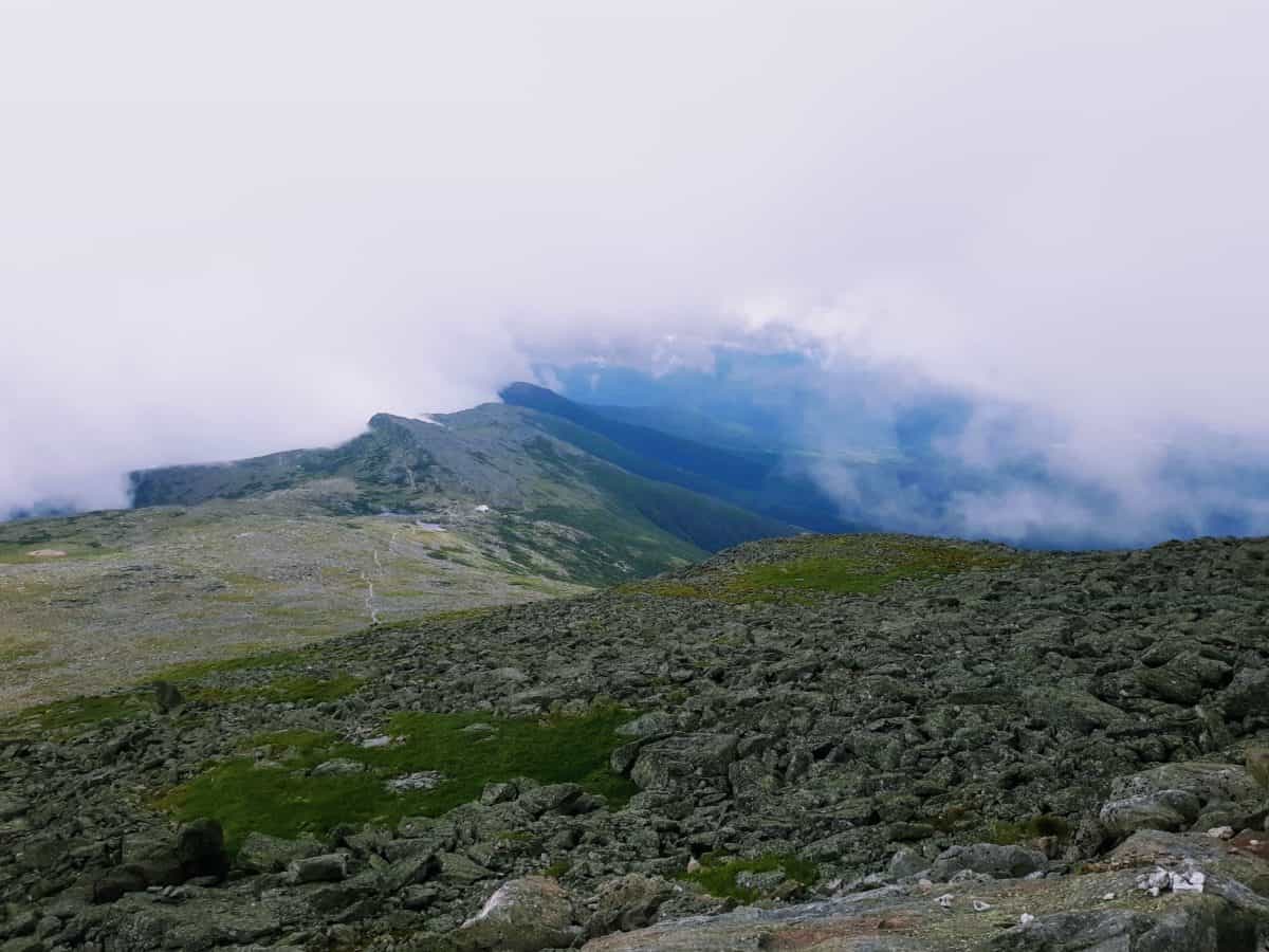
Hiking Mount Washington is a completely different animal than driving it. It is simultaneously some of the most beautiful hikes in the U.S., as well as some of the most dangerous hikes in the U.S.! A large part of what makes these hikes dangerous is Mt. Washington’s treacherous weather. There is a reason it is often referred to as the home of the worst weather in the world!
So just how dangerous is the weather on Mt. Washington, and how does that effect one’s decision to hike it? Record wind speeds and temperatures are just part of the norm here. Mt. Washington has recorded temperatures from its summit in the 20’s in July. In winter, temperatures can dip far below zero, with a record of negative 47 degrees set in January 1934!
And the temperatures aren’t all! Mt. Washington’s summit has seen wind gusts up to 231 miles per hour. Blustery conditions are a regular thing here, and in winter, gusts of 100 miles per hour or more occur at least weekly. Now imagine combining these volatile factors of wind and extreme temperatures together!

If you planning some Mount Washington hiking, preparation is key! Unfortunately, this mountain has earned its reputation partially from unaware hikers dressed inappropriately for the plunging temperatures they encounter and thus suffering hypothermia, or hikers who have literally been blown to their deaths by unimaginable wind gusts. The Mt. Washington summit has literally never been warmer than 72 degrees in recorded history. Now factor in a hike that is lengthy, steep, rocky, and rugged.
To emphasize just how potentially deadly this hike can be, over 150 people have perished on this peak. There are ways to enjoy this hike, but do not assume you will catch Mt. Washington on an “off day”. You absolutely have to be ready for the elements!
Before attempting any Mount Washington hiking, check the live updates from the Mt. Washington Observatory for current conditions including temperatures, wind speeds, wind chill, and visibility, as well as their projected forecast. Weather conditions are known to change rapidly on Mt. Washington, with 30 degree temperature changes a norm between the base and the summit. You can also check mountain-forecast.com, for weather conditions that are specific to mountains, because weather at higher altitude can often be drastically different than at the base of a mountain.
Extreme wind gusts and fog are common visitors to the Mt. Washington summit. It is completely feasible that even on a summer hike, you may experience freezing temperatures, wind gusts in excess of 70 miles per hour, and limited visibility at the summit. This is why it is so important to bring enough and proper layers, all required gear, as well as other gear needed for emergency situations.
Trail Options to the Highest Point in New Hampshire
You can choose from many different trails on Mt. Washington, but here are some of the most popular and utilized ones, including trails on the east and west sides of Mt. Washington.

Hiking Mt. Washington from the East
Accessing Mt. Washington from the East means access to plentiful free parking at the Pinkham Notch Visitor Center, lodging and dining options, and the availability of the Mt. Washington Auto Road hiker shuttle.
So when is the best time of year to hike Mount Washington? While Mount Washington hiking can be potentially dangerous year round, the best time of year is late April – early September.
Below are your trail options for hiking Mt. Washington from the east:
#1: The Tuckerman Ravine Trail
The Tuckerman Ravine Trail is heralded as the easiest and most popular way to hike to the Mt. Washington summit. The trailhead is located at the Pinkham Notch Visitor Center on Route 16.
Length: 7.6 miles roundtrip
Elevation Gain: 4,255 feet
 Mt Washington Tuckerman Ravine Trail Elevation Chart
Rating: Difficult
Tuckerman Ravine is 7.6 miles roundtrip, with just over 4,200 feet of elevation gain. This route can be heavily trafficked in prime conditions, and passes beautiful landmarks such as Hermit Lake. When climbing the ravine, expect narrow switchbacks, steep climbing, and often slippery conditions.
The last mile or so of the Tuckerman Ravine Trail to the Mt. Washington summit is arguably the hardest, because it morphs from less hiking to more rock hopping, topped off with one treacherously steep final climb to the top! Many hikers opt to descend the Lion Head Trail.
#2: The Lion Head Trail
Length: 7.7 miles roundtrip out and back
Elevation Gain: 4,209 feet

Rating: Difficult
The Lion Head trailhead is also located at the Pinkham Notch Visitor Center. Almost equal in length to the Tuckerman Ravine Trail at 7.7 miles roundtrip, but with steeper sections and more rugged terrain during its 4,209 feet of elevation gain.
One advantage that the Lion Head Trail has is it generally is less crowded than the Tuckerman Ravine Trail, and it offers stunning views of Tuckerman Ravine from above treeline, as this trail winds its way along the ravine’s northern border.
#3: The Boott Spur Trail
Length: 5.7 miles roundtrip out and back
Elevation Gain: 3, 451 feet

Rating: Difficult
The Boott Spur Trail is 5.7 miles roundtrip, but considered difficult at about 3,500 feet in elevation gain. This trail is considered by some to hold better views, as it breaks through treeline quicker.
Like the Lion Head Trail, Boott Spur climbs a ridge of Tuckerman Ravine, but on this trail it is the southern border. Also like the Lion Head Trail, the Boott Spur Trail is considered less trafficked than the Tuckerman Ravine Trail. A loop hike can be made with Boott Spur Trail and the Tuckerman Ravine Trail or the Lion’s Head Trail. Parking for the trailhead is also at the Pinkham Notch Visitor Center.
*Parking for these trails fills up quick on weekends, so get there early!
*There is a registry at the Pinkham Notch Visitor Center – if you are hiking from here, be sure to fill it out in case of an emergency! Also, fill out this wilderness hiking safety contact form before heading out on the trail!
Hiking Mt. Washington from the West
These are two of the most popular trails to Mt. Washington approaching from the west:
#1: The Jewell Trail/Gulfside Trail
Length: 9.3 miles roundtrip out and back
Elevation Gain: 4,235 feet
Rating: Difficult
The Jewell Trail is possibly the easiest way to ascend Mt. Washington. The start of the Jewell Trail can be found at the trailhead located in the parking lot for the Cog Railway Station on Base Road, on the western side of Mt. Washington.
At 9.3 miles roundtrip in length, the main advantage with this trail is the less steep elevation gain of only 4,235 feet, considered more moderate compared to some of the steeper options. Plus you get the added bonus of witnessing the Cog Railway on its ascent, though that may have the opposite affect of making you jealous!
#2: The Ammonoosuc Ravine Trail
Length: 8.2 miles roundtrip out and back
Elevation Gain: 3,795 feet

Rating: Difficult
This trail also starts at the parking lot of the Cog Railway, and is a little shorter than the Jewell Trail at 8.2 miles roundtrip. You can do a loop hike with the Ammonoosuc Ravine Trail and the Jewell Trail.
Look for the stream that runs parallel to the trail, which eventually passes several waterfalls. One big draw to hiking the Ammonoosuc Ravine Trail is encountering the Lake of the Clouds Hut, which is about 3 miles in.
*Thinking you’d like to hike up, but not sure if you want to hike down? Or maybe the other way around? You’re in luck, because Mt. Washington also offers reserved “hiker shuttles” which can be reserved to take hikers that have hiked up back down to the base of Mt. Washington, or vice versa. They serve as one way up or down shuttles, and bookings can be reserved online here. Do be aware that the 2 hour guided tour is not the same as a hiker shuttle, they are two separate operations.
*A note on Mount Washington hiking in winter – I wouldn’t recommend it, with the exception of those with extensive experience in winter conditions hiking, as well as extensive experience using the specialized gear such as crampons and ice axes a winter hike would require. For any other type of hiker it’s a no.
The Summit of Mount Washington New Hampshire
The Mt. Washington summit is unlike any of the other 49 U.S. state high points, and a large part of that is traced in its history and weather related pursuits. Whether you drive or hike it, at the summit you will find the Mt. Washington Observatory, dedicated to tracking and learning more about the unique weather patterns in this region.
Early scientists erected one of the world’s first summit mountain stations on the top of Mt. Washington in the late 1800’s, which has now become the Mt. Washington Observatory. Researchers continue to actively learn more about Mt. Washington’s weather patterns today from the summit.
In addition to the Mt. Washington Observatory, there is also the Sherman Adams Visitor’s Center and observation deck at the summit, a museum at the Tip Top House, a cafeteria and gift shops, and ample area to walk around outside and sightsee! You can even send a post card from the post office at the summit!
Don’t miss the Mt. Washington summit sign either! Expect the weather to be different, sometimes drastically different, than it was at the base of the mountain!
Gear Recs for Mount Washington Hiking
These are not just recommendations, in an environment like Mt. Washington they are necessities. Do not underestimate the unpredictability of Mt. Washington New Hampshire!
- footwear! Every hiking route to the top of Mt. Washington involves significant elevation gain over challenging terrain, some of which is very rugged, rocky, and cantankerous! So a waterproof hiking boot with stability, support, and grip is a must!
- water and a water transportation system! Things can happen when hiking Mt. Washington, so you need to bring enough water to be prepared for the unexpected. No matter which trail option to the Mt. Washington summit you choose to take, they are all long, arduous, hikes, and I would recommend bringing at least 3 liters of water in an reliable water transportation system. My favorite system is this 3 liter wide mouthed Platypus water hydration bladder, and it is my favorite because the wide opening makes it easy to clean, and the portability and easy access of this system makes it great for hydrating on the go!
- a day pack! A mid sized day pack, like the Camelback Helena model that I use on all my day hikes, is best for hiking day hikes like Mt. Washington. This model day pack comes with a 2.5 liter water bladder included, but a 3 liter water hydration bladder easily fits inside as well, which is what I personally use. A day pack of this size will also give you adequate room to pack the rest of the 10 hiking essentials, plenty of snacks, and extras like a spare pair of wool socks if you encounter wet conditions.
- food! Again, this is a long, challenging undertaking to reach the highest point in New Hampshire, so fuel properly. Opt for food that is easily digestible, easy to pack, and energy packed! Here’s the food inside my day pack:
- tuna packets – super lightweight, compact, and a good source of protein and energy
- almonds – great source of easy to snack on energy
- beef jerky – a good salty food option for replacing sodium
- RX bars – for a healthy, simplified, boost
- applesauce squeezable packets – this is a personal favorite of mine, because I mostly just love applesauce, but they are nice for a little moisture content, and they are something that has always been easily digestible for me, and compact and easy to eat on the go!
- peanut butter pouches– always a great option for a quick, on the go, energy boost
- NUUN tablets – I don’t always end up using these, but I always bring them if I feel the need for an electrolyte level replacement and boost
- proper layers! Please AVOID moisture clinging COTTON at all costs! When moisture builds up and clings to skin in cold conditions, it can literally lead to hypothermia. Opt instead for moisture wicking, breathable, and quick drying materials like merino wool! As the temperatures at Mt. Washington are unpredictable, you will want to layer appropriately. Here are my favorite merino wool clothing item recommendations:
-
- a breathable, wool mid layer for really cold hiking, like this Icebreaker Merino Women’s Quantum jacket to layer over your base layer and under your outer layer
-
- hiking pants and warm leggings. My typical base layer leggings that I hike and run in are my Icebreaker BodyFitZone 260 Merino wool leggings. In dryer, warmer conditions, my outer layer hiking pants are these durable Columbia pants. For colder, windier conditions where I need an extra protective outer shell, my go to are these Pantagonia Torrentshell Pants that are windproof and waterproof.
-
- reversible Buff head and neck covering for wind and cold. These little accessories are awesome! Not only are they available in fun prints and reversible, but they are incredibly functional as well. Use them as a headband to cover ears from wind and cold, and keep hair in place. Pull it down over your neck to cover exposed skin, or pull it up to cover your nose and mouse in frigid temperatures. There really are so many good reasons to add a Buff to your hiking inventory.
-
- more head coverings! The Mt. Washington weather can be brutal, so it isn’t a bad idea to bring along other head covering options to protect from cold and wind, like this Smartwool cuffed beanie, or this Gore brand headband that is famous among cyclists for its wind blocking abilities!
-
- gloves! North Face is my top recommendation for gloves, specifically, their fleece infused Etip glove line. Invest in the traditional Etip glove, or the heavyweight Denali Etip glove for additional thermal protection. This line is touch screen capable and compatible.
-
- a breathable outer layer to protect from the elements. This jacket is one of my hiking inventory favorites, because it repels the weather, is lightweight, and is lined with Merino wool!
- For really testy weather, you need a heavier duty jacket like this fully waterproof option, the IceBreaker Stratus Transcend jacket.
- a map, compass, and personal emergency communication device! There are hard copy, tangible trail maps of the White Mountains which I would recommend hiking with. Given the potential for life threateningly dangerous weather conditions, I would also strongly recommend hiking with a backup in order to have a way to signal for help with an emergency communication device like this one!
- emergency shelter! An emergency shelter should be a part of the 10 hiking essentials, and my favorite lightweight, compact, effective, and affordable emergency shelter is this handy little SOL Bivy!
- headlamp – even the most experienced hikers may take longer than they think to summit and descend Mt. Washington. It is best to have a backup plan ready by bringing a reliable headlamp like this one!
- first aid kit! Another important part of the 10 hiking essentials, and very crucial for a Mt. Washington undertaking.
- fire starting supplies! In the event of an emergency on this mountain, you will be thankful for the ability to create a fire for warmth. Fire starting supplies are another item in the 10 hiking essentials.
- trekking poles! There are “easier” ways and harder ways to summit Mt. Washington, but realistically, none of them are even close to easy! All of the trails involve steep, rugged ascents, and you’ll appreciate a extra helping hand of support. These hiking poles are the best out there and have unwaveringly supported me on many steep uphill climbs and summits, like the highest point in Colorado at Mount Elbert, or the long and rocky state high point hike of New York at Mount Marcy!

Mount Washington Via the Cog Railway
There is actually yet a third way to access the highest point in New Hampshire! The Cog Railway, which travels up the west side of Mt. Washington from the Marshfield Station! The Cog Railway has operated for over 150 years on Mt. Washington, and continues to provide visitors another unique option for experiencing this summit. A trip up Mt. Washington on the Cog is a graceful ascent through scenic panoramas, unique formations, and steep climbs! It is recommended to reserve ahead of time, and bookings can be completed online here.
*The Cog Railway does not operate its summit trips in the winter. The Cog still operates to lower elevation locations in winter. In winter, Mt. Washington does operate a SnowCoach tour which takes guests on trips to treeline.
Curious about the rest of the 50 U.S. State High Points?
You can read all about the ones I have summitted so far HERE, plus grab a free high points graphic!
PIN for LATER!